Country:
 Australia
Region:
City:
Latitude and Longitude:
Time Zone:
Postal Code:
IP information under different IP Channel
ip-api
Country
Region
City
ASN
Time Zone
ISP
Blacklist
Proxy
Latitude
Longitude
Postal
Route
IPinfo
Country
Region
City
ASN
Time Zone
ISP
Blacklist
Proxy
Latitude
Longitude
Postal
Route
MaxMind
Country
Region
City
ASN
Time Zone
ISP
Blacklist
Proxy
Latitude
Longitude
Postal
Route
Luminati
Country
AURegion
vic
City
melbourne
ASN
Time Zone
Australia/Melbourne
ISP
TPG Telecom Limited
Latitude
Longitude
Postal
db-ip
Country
Region
City
ASN
Time Zone
ISP
Blacklist
Proxy
Latitude
Longitude
Postal
Route
ipdata
Country
Region
City
ASN
Time Zone
ISP
Blacklist
Proxy
Latitude
Longitude
Postal
Route
Popular places and events near this IP address

City of Maroondah
Local government area in Victoria, Australia
Distance: Approx. 2132 meters
Latitude and longitude: -37.8067925,145.2632003
The City of Maroondah is a local government area in Victoria, Australia in the eastern suburbs of Melbourne. Maroondah had a population of 115,043 in August 2021. The City of Maroondah was created through the amalgamation the former Cities of Ringwood and Croydon on 15 December 1994.

Croydon railway station, Melbourne
Railway station in Melbourne, Australia
Distance: Approx. 324 meters
Latitude and longitude: -37.7954,145.2805
Croydon railway station is a commuter railway station on the Lilydale line, part of the Melbourne railway network. It serves the eastern Melbourne suburb of Croydon in Victoria, Australia. Croydon is an elevated premium station, featuring two side platforms.

Mooroolbark railway station
Railway station in Melbourne, Australia
Distance: Approx. 2856 meters
Latitude and longitude: -37.7847,145.3125
Mooroolbark railway station is a commuter railway station on the Lilydale line, serving the eastern Melbourne suburb of Mooroolbark in Victoria, Australia. Mooroolbark is an elevated premium station, featuring an island platform with two faces. It opened on 10 October 1887 with the current station provided in 2021.

Croydon South, Victoria
Suburb of Melbourne, Victoria, Australia
Distance: Approx. 2208 meters
Latitude and longitude: -37.816,145.278
Croydon South is a suburb of Melbourne, Victoria, Australia, 29 kilometres (18 mi) east of Melbourne's Central Business District, located within the City of Maroondah local government area. Croydon South recorded a population of 4,759 at the 2021 census. Croydon South has two main retail areas, Eastfield Shopping Centre on the corner of Eastfield and Bayswater Roads, and Merrindale Shopping Centre on Dorset Road.

Kilsyth, Victoria
Suburb of Melbourne, Victoria, Australia
Distance: Approx. 2893 meters
Latitude and longitude: -37.802,145.316
Kilsyth ( ) is a suburb of Melbourne, Victoria, Australia, 32 kilometres (20 mi) east from Melbourne's central business district (CBD), located within the City of Maroondah and the Shire of Yarra Ranges local government areas. Kilsyth recorded a population of 11,699 at the 2021 census. Most of Kilsyth is located within the Shire of Yarra Ranges, the rest is within the City of Maroondah.
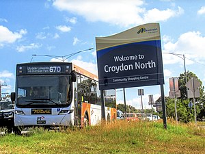
Croydon North, Victoria
Suburb of Melbourne, Victoria, Australia
Distance: Approx. 2534 meters
Latitude and longitude: -37.774,145.286
Croydon North is a suburb of Melbourne, Victoria, Australia, 31 kilometres (19 mi) east of Melbourne's Central Business District, located within the City of Maroondah local government area. Croydon North recorded a population of 8,092 at the 2021 census. Croydon has 3 major shopping strips, two on either side of Maroondah Highway (continuing shortly down Dorset and Exeter roads) and the other on Exeter Road just next to Kinta Ct.

Luther College (Victoria)
Independent school in Croydon Hills, Victoria, Australia
Distance: Approx. 1816 meters
Latitude and longitude: -37.783,145.2726
Luther College is a co-educational independent secondary school of the Lutheran Church of Australia located in the outer-eastern suburb of Croydon Hills in Melbourne, Victoria, Australia. It maintains a close relationship with the Outer Eastern Lutheran Church parish of the Lutheran Church of Australia, which congregates in the school's chapel facilities. It provides education for years 7–12.

Croydon, Victoria
Suburb of Melbourne, Victoria, Australia
Distance: Approx. 654 meters
Latitude and longitude: -37.791,145.282
Croydon is a suburb of Melbourne, Victoria, Australia, 30 kilometres (19 mi) east of Melbourne's Central Business District, located within the City of Maroondah local government area. Croydon recorded a population of 28,608 at the 2021 census.

Yarra Valley Grammar
Independent, co-educational school in Ringwood, Victoria, Australia
Distance: Approx. 2551 meters
Latitude and longitude: -37.78361111,145.26
Yarra Valley Grammar School (YVG) is a private co-educational Anglican grammar school, located in Ringwood, a north-eastern suburb of Melbourne, Australia. Yarra Valley was founded as an Anglican day school for boys in 1966, before transitioning to a co-educational model in 1978. The school is a member of AGSV (Associated Grammar Schools of Victoria), and has been periodically ranked amongst the top 50 schools in the state according to VCE and ATAR results, being placed 25th in Victoria in 2023.

City of Croydon
Local government area in Victoria, Australia
Distance: Approx. 258 meters
Latitude and longitude: -37.796,145.281
The City of Croydon was a local government area about 30 kilometres (19 mi) east of Melbourne, the state capital of Victoria, Australia. The city covered an area of 34.32 square kilometres (13.25 sq mi), and existed from 1961 until 1994.

Electoral district of Croydon (Victoria)
State electoral district of Victoria, Australia
Distance: Approx. 817 meters
Latitude and longitude: -37.79,145.28
The electoral district of Croydon is an electoral district of the Victorian Legislative Assembly, located in the east of Melbourne. It was created in the redistribution of electoral boundaries in 2013, and came into effect at the 2014 state election. It largely covers the area of the abolished district of Kilsyth, covering outer eastern suburbs in Melbourne.

Maroondah Hospital
Hospital in Ringwood East, Victoria, Australia
Distance: Approx. 2760 meters
Latitude and longitude: -37.8067925,145.2551448
Maroondah Hospital is a public hospital located in the Melbourne suburb of Ringwood East, Victoria, Australia. Affiliated with Deakin University the hospital provides clinical rotations for students enrolled in years 3 and 4 of the medical student programs, focusing on children's health. The hospital provides secondary acute care, and acute adult mental health services along with an emergency department which is open 24 hours, 7 days a week.
Weather in this IP's area
clear sky
11 Celsius
10 Celsius
9 Celsius
13 Celsius
1019 hPa
80 %
1019 hPa
1005 hPa
10000 meters
1.64 m/s
2.81 m/s
33 degree
06:40:43
19:30:44