Country:
 Australia
Region:
City:
Latitude and Longitude:
Time Zone:
Postal Code:
IP information under different IP Channel
ip-api
Country
Region
City
ASN
Time Zone
ISP
Blacklist
Proxy
Latitude
Longitude
Postal
Route
IPinfo
Country
Region
City
ASN
Time Zone
ISP
Blacklist
Proxy
Latitude
Longitude
Postal
Route
MaxMind
Country
Region
City
ASN
Time Zone
ISP
Blacklist
Proxy
Latitude
Longitude
Postal
Route
Luminati
Country
AURegion
nsw
City
sydney
ASN
Time Zone
Australia/Sydney
ISP
Origin Net
Latitude
Longitude
Postal
db-ip
Country
Region
City
ASN
Time Zone
ISP
Blacklist
Proxy
Latitude
Longitude
Postal
Route
ipdata
Country
Region
City
ASN
Time Zone
ISP
Blacklist
Proxy
Latitude
Longitude
Postal
Route
Popular places and events near this IP address

Sydney Hilton Hotel bombing
Terror attack in 1978 in Sydney, Australia
Distance: Approx. 155 meters
Latitude and longitude: -33.87194444,151.20722222
The Sydney Hilton Hotel bombing occurred on 13 February 1978, when a bomb exploded outside the Hilton Hotel in George Street, Sydney, Australia. The hotel was hosting the first Commonwealth Heads of Government Regional Meeting (CHOGRM), a regional offshoot of the biennial meetings of the heads of government from across the Commonwealth of Nations. The bomb was planted in a rubbish bin and exploded when the bin was emptied into a garbage truck outside the hotel at 12:40 a.m.

Queen Victoria Building
Building in the central business district of Sydney, Australia
Distance: Approx. 105 meters
Latitude and longitude: -33.871758,151.206666
The Queen Victoria Building (abbreviated as the QVB) is a heritage-listed late-nineteenth-century building located at 429–481 George Street in the Sydney central business district, in the state of New South Wales, Australia. Designed by the architect George McRae, the Romanesque Revival building was constructed between 1893 and 1898 and is 30 metres (98 ft) wide by 190 metres (620 ft) long. The domes were built by Ritchie Brothers, a steel and metal company that also built trains, trams and farm equipment.

Market Street, Sydney
Street in Sydney, Australia
Distance: Approx. 58 meters
Latitude and longitude: -33.87083333,151.20658333
Market Street is a street in the city centre of Sydney in New South Wales, Australia. It runs from Sussex Street near Darling Harbour in the west, to Elizabeth Street at St James railway station in the east. Market Street is located in the heart of the Sydney central business district shopping precinct.

Hong Kong House
Heritage-listed building in Sydney, Australia
Distance: Approx. 184 meters
Latitude and longitude: -33.87263,151.20629
Hong Kong House, also known since 1995 as the Hong Kong Economic and Trade Office, Sydney, is a landmark heritage building and former hotel in the Sydney central business district, City of Sydney, New South Wales, Australia. Built in 1891 to a design by Ambrose Thornley, it is located on 80 Druitt Street, at the corner with York Street, and is adjacent to other prominent heritage landmarks, the Sydney Town Hall and the Queen Victoria Building. Formerly known as Gresham Hotel, the property was added to the New South Wales State Heritage Register on 2 April 1999.
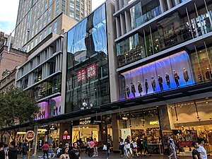
MidCity
Shopping mall in New South Wales, Australia
Distance: Approx. 210 meters
Latitude and longitude: -33.869622,151.207546
MidCity is a shopping centre in the Sydney central business district. It is located on Pitt Street Mall, adjacent to Westfield Sydney, The Strand Arcade and is diagonally opposite Glasshouse. MidCity has over 24 stores across Fashion, Beauty, Fitness and Lifestyle.

State Theatre (Sydney)
Heritage-listed theatre in Sydney, Australia
Distance: Approx. 132 meters
Latitude and longitude: -33.8712,151.2074
The State Theatre is a 2034 seat heritage listed theatre located at 47–51 Market Street, in the Sydney central business district in the City of Sydney local government area of New South Wales, Australia. The theatre was designed by Henry Eli White with assistance from John Eberson and built between 1926 and 1929. It hosts film screenings, live theatre and musical performances, and since 1974 it has been the home of the annual Sydney Film Festival.

Genesian Theatre
Australian amateur theatre company
Distance: Approx. 166 meters
Latitude and longitude: -33.8720248,151.2046834
The Genesian Theatre is an amateur theatre company based in Sydney, Australia, named in honour of Saint Genesius, patron saint of actors. Formed in 1944 by members of the Sydney Catholic Youth Organisation, it has since evolved into a community theatre in the heart of the Sydney central business district.

Royal Clock
Clock in Sydney, Australia
Distance: Approx. 134 meters
Latitude and longitude: -33.872041,151.206713
The "Royal Clock" is located on the upper level of the southern half of the Queen Victoria Building in Sydney, Australia. It was designed by Neil Glasser and made by Thwaites & Reed of Hastings in England, and when activated, displays scenes of English royalty. The plaque on the side of the clock reads "By appointment to Her Majesty Queen Elizabeth II. Turret Clockmakers Thwaites & Reed Ltd Hastings England".

Statue of Queen Victoria, Sydney
Distance: Approx. 207 meters
Latitude and longitude: -33.872718,151.206851
The seated Statue of Queen Victoria, currently in Sydney, New South Wales, Australia, was made by John Hughes in 1908 and was originally located in Dublin. Made of bronze, it is situated on the corner of Druitt and George Street in front of the Queen Victoria Building. It was the last royal statue to have been erected in Ireland.

Palace Theatre, Sydney
Australian theatre
Distance: Approx. 206 meters
Latitude and longitude: -33.8718,151.208
The Palace Theatre was a theatre located at 259–261 Pitt Street in the Sydney central business district. It was built in 1896 by businessman George Adams as a supplement to his Tattersall's Hotel next door. The theatre hosted live performances until the 1930s, when it was converted to a cinema.

Clarence Street Police Station
Historic site in New South Wales, Australia
Distance: Approx. 162 meters
Latitude and longitude: -33.8724,151.2055
The Clarence Street Police Station is a heritage-listed former police station and now community service office located at 281 Clarence Street, Sydney, Australia. It was designed by James Barnet as the NSW Government Architect and was built from 1890 to 1928. It was added to the New South Wales State Heritage Register on 2 April 1999.
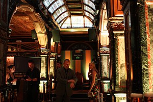
Marble Bar, Sydney
Bar in Sydney, Australia
Distance: Approx. 189 meters
Latitude and longitude: -33.8716299,151.207888
Marble Bar is an historic bar in Sydney, Australia. Originally constructed in the George Adams-owned O'Brien Hotel in 1893, it was dismantled in 1969, then moved and rebuilt in the subterranean level of the Hilton Sydney, on George Street, in 1973. It is now a heritage-listed building.
Weather in this IP's area
light rain
13 Celsius
13 Celsius
12 Celsius
14 Celsius
1023 hPa
83 %
1023 hPa
1015 hPa
10000 meters
4.63 m/s
330 degree
75 %
06:20:03
19:04:01