Country:
 Australia
Region:
City:
Latitude and Longitude:
Time Zone:
Postal Code:
IP information under different IP Channel
ip-api
Country
Region
City
ASN
Time Zone
ISP
Blacklist
Proxy
Latitude
Longitude
Postal
Route
IPinfo
Country
Region
City
ASN
Time Zone
ISP
Blacklist
Proxy
Latitude
Longitude
Postal
Route
MaxMind
Country
Region
City
ASN
Time Zone
ISP
Blacklist
Proxy
Latitude
Longitude
Postal
Route
Luminati
Country
AURegion
nsw
City
sydney
ASN
Time Zone
Australia/Sydney
ISP
Origin Net
Latitude
Longitude
Postal
db-ip
Country
Region
City
ASN
Time Zone
ISP
Blacklist
Proxy
Latitude
Longitude
Postal
Route
ipdata
Country
Region
City
ASN
Time Zone
ISP
Blacklist
Proxy
Latitude
Longitude
Postal
Route
Popular places and events near this IP address

HMAS Advance (P 83)
Distance: Approx. 220 meters
Latitude and longitude: -33.86916667,151.19991667
HMAS Advance (P 83) was an Attack-class patrol boat of the Royal Australian Navy (RAN). Constructed during 1967 and commissioned into the RAN in 1968, Advance operated from Darwin and patrolled northern Australian waters. During her career, the patrol boat shadowed a Soviet trawler, survived Cyclone Tracy, was used for filming of the television series Patrol Boat, and participated in the RAN's first anti-terrorism patrol of the North West Shelf.

USS Canberra (CA-70)
US Navy guided missile cruiser
Distance: Approx. 267 meters
Latitude and longitude: -33.8694298,151.1986428
USS Canberra (CA-70/CAG-2) was a Baltimore-class cruiser and later a Boston-class guided missile cruiser of the United States Navy (USN). Originally to be named USS Pittsburgh, the ship was renamed before launch to honor the Australian cruiser HMAS Canberra sunk during the Battle of Savo Island. Canberra was the first USN warship named after a foreign capital city, and one of the few named after a foreign warship not captured in battle with a USN ship.
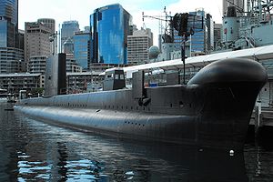
HMAS Onslow
Royal Australian Navy submarine (1969–1999)
Distance: Approx. 229 meters
Latitude and longitude: -33.86925,151.19995
HMAS Onslow (SS 60/SSG 60) is one of six Oberon-class submarines, previously operated by the Royal Australian Navy (RAN). The submarine was named after the town of Onslow, Western Australia, and Sir Alexander Onslow, with the boat's motto and badge derived from Onslow's family heritage. Ordered in 1963, Onslow was laid down at the end of 1967 by Scotts Shipbuilding and Engineering Company in Scotland, launched almost a year later, and commissioned into the RAN at the end of 1969.

King Street Wharf
Wharf in Sydney, Australia
Distance: Approx. 187 meters
Latitude and longitude: -33.86737,151.20172
King Street Wharf is a mixed-use tourism, commercial, residential, retail and maritime development on the eastern shore of Darling Harbour, an inlet of Sydney Harbour, Australia. Located on the western side of the city's central business district, the complex served as a maritime industrial area in the early and mid 20th century. It was redeveloped as part of extensive urban renewal projects around Sydney Harbour in the 1980s and 90s.

City of Sydney
Local government area in Australia
Distance: Approx. 65 meters
Latitude and longitude: -33.86666667,151.2
The City of Sydney is the local government area covering the Sydney central business district and surrounding inner city suburbs of the greater metropolitan area of Sydney, New South Wales, Australia. Established by Act of Parliament in 1842, the City of Sydney is the oldest, and the oldest-surviving, local government authority in New South Wales, and the second-oldest in Australia, with only the City of Adelaide being older by two years. Given its prominent position, historically, geographically, economically and socially, the City of Sydney has long been a source of political interest and intrigue.

HMAS Vampire (D11)
1959-1986 Daring-class destroyer of the Royal Australian Navy
Distance: Approx. 220 meters
Latitude and longitude: -33.86916667,151.19991667
HMAS Vampire was the third of three Australian-built Daring-class destroyers serving in the Royal Australian Navy (RAN). One of the first all-welded ships built in Australia, she was constructed at Cockatoo Island Dockyard between 1952 and 1959, and was commissioned into the RAN a day after completion. Vampire was regularly deployed to South East Asia during her career: she was attached to the Far East Strategic Reserve on five occasions, including during the Indonesia-Malaysia Confrontation, and escorted the troop transport HMAS Sydney on six of the latter's twenty-five transport voyages to South Vietnam.

Sydney Heritage Fleet
Maritime museum in New South Wales, Australia
Distance: Approx. 117 meters
Latitude and longitude: -33.8675,151.1985
Sydney Heritage Fleet, is the trading name of Sydney Maritime Museum Ltd., a public company in Sydney, New South Wales, Australia. The Fleet restores and operates a number of historic vessels including the barque James Craig. In 2003 the World Ship Trust awarded James Craig its prestigious Maritime Heritage Award.

Australian National Maritime Museum
Maritime museum in New South Wales, Australia
Distance: Approx. 241 meters
Latitude and longitude: -33.869167,151.198611
The Australian National Maritime Museum (ANMM) is a federally operated maritime museum in Darling Harbour, Sydney. After considering the idea of establishing a maritime museum, the federal government announced that a national maritime museum would be constructed at Darling Harbour, tied into the New South Wales state government's redevelopment of the area for the Australian bicentenary in 1988. The museum building was designed by Philip Cox, and although an opening date of 1988 was initially set, construction delays, cost overruns, and disagreements between the state and federal governments over funding responsibility pushed the opening to 1991.

MV Krait
Australian historic vessel
Distance: Approx. 126 meters
Latitude and longitude: -33.86833333,151.19972222
The MV Krait is a wooden-hulled vessel famous for its use during World War II by the Z Special Unit (Z Force) of Australia during the raid against Japanese ships anchored in Singapore Harbour. The raid was known as Operation Jaywick. The MV Krait is on display at the Australian National Maritime Museum (ANMM) in Sydney.

King Street, Sydney
Street in Sydney, Australia
Distance: Approx. 277 meters
Latitude and longitude: -33.868734,151.202076
King Street is a street in the Sydney central business district in New South Wales, Australia. It stretches from King Street Wharf and Lime Street near Darling Harbour in the west, to Queens Square at St James railway station in the east.

Pyrmont Bay ferry wharf
Sydney Ferries ferry wharf
Distance: Approx. 139 meters
Latitude and longitude: -33.8682,151.19881
Pyrmont Bay ferry wharf is located on the western side of Darling Harbour serving the inner-city Sydney suburb of Pyrmont. It is located adjacent to the Australian National Maritime Museum and close to The Star Casino.

CLS4 Carpentaria
Distance: Approx. 170 meters
Latitude and longitude: -33.868139,151.198259
Commonwealth Lightship 4 (CLS4) Carpentaria is a lightship that was in service from 1917 to 1985 with the Commonwealth Lighthouse Service, built at the Cockatoo Island Dockyard and commissioned in 1917. The vessel is named after the Gulf of Carpentaria, where it spent most of its service life together with its sister ship CLS2 (also named Carpentaria).
Weather in this IP's area
light rain
13 Celsius
13 Celsius
12 Celsius
14 Celsius
1023 hPa
84 %
1023 hPa
1022 hPa
10000 meters
4.63 m/s
330 degree
75 %
06:20:05
19:04:03