Country:
 Chinese mainland
Region:
City:
Latitude and Longitude:
Time Zone:
Postal Code:
IP information under different IP Channel
ip-api
Country
Region
City
ASN
Time Zone
ISP
Blacklist
Proxy
Latitude
Longitude
Postal
Route
IPinfo
Country
Region
City
ASN
Time Zone
ISP
Blacklist
Proxy
Latitude
Longitude
Postal
Route
MaxMind
Country
Region
City
ASN
Time Zone
ISP
Blacklist
Proxy
Latitude
Longitude
Postal
Route
Luminati
Country
CNASN
Time Zone
Asia/Shanghai
ISP
CHINA UNICOM China169 Backbone
Latitude
Longitude
Postal
db-ip
Country
Region
City
ASN
Time Zone
ISP
Blacklist
Proxy
Latitude
Longitude
Postal
Route
ipdata
Country
Region
City
ASN
Time Zone
ISP
Blacklist
Proxy
Latitude
Longitude
Postal
Route
Popular places and events near this IP address
Midong, Ürümqi
District in Xinjiang, China
Distance: Approx. 1347 meters
Latitude and longitude: 43.8,87.58333333
Midong District (Chinese: 米东区; pinyin: Mǐdōng Qū; Uyghur: مىچۈەن-كۆكتاغ رايونى, romanized: Michüen-Köktagh Rayoni, Miqüen-Kɵktaƣ Rayoni, Мичүән-Көктағ Райони) is one of 7 urban districts of the prefecture-level city of Ürümqi, the capital of Xinjiang Uygur Autonomous Region, Northwest China. Its land area is 3,408 km2 (1,316 sq mi); it has a population of 296,000.
Saybag, Ürümqi
District in Xinjiang, China
Distance: Approx. 1347 meters
Latitude and longitude: 43.8,87.58333333
Saybag District (Uyghur: سايباغ رايونى, romanized: Saybagh Rayoni, Saybaƣ Rayoni, Saybag Rayoni, Сайбағ Райони; Chinese: 沙依巴克区; pinyin: Shāyībākè Qū) is one of 7 urban districts of the prefecture-level city of Ürümqi, the capital of Xinjiang Uygur Autonomous Region, Northwest China. It contains an area of 422 km2 (163 sq mi). According to the 2002 census, it has a population of 440,000.

Tianshan, Ürümqi
District in Xinjiang, China
Distance: Approx. 1347 meters
Latitude and longitude: 43.8,87.58333333
Tianshan District (Chinese: 天山区; pinyin: Tiānshān Qū; Uyghur: تەڭرىتاغ رايونى, romanized: Tengritagh Rayoni, Təngritaƣ Rayoni, Tengritag Rayoni, Тәңритағ Райони) is one of 7 urban districts of the prefecture-level city of Ürümqi, the capital of Xinjiang Uygur Autonomous Region, Northwest China. It is a core urban district of Ürümqi. It contains an area of 171 km2 (66 sq mi).

Shuimogou, Ürümqi
District in Xinjiang, China
Distance: Approx. 1347 meters
Latitude and longitude: 43.8,87.58333333
Shuimogou District or Bulaqtagh District (Chinese: 水磨沟区; pinyin: Shuǐmógōu Qū; Uyghur: بۇلاقتاغ رايونى, romanized: Bulaqtagh Rayoni) is one of 7 urban districts of the prefecture-level city of Ürümqi, the capital of Xinjiang Uygur Autonomous Region, Northwest China. It contains an area of 91 km2 (35 sq mi). According to the 2002 census, it has a population of 150,000.

Dabancheng, Ürümqi
District in Xinjiang, China
Distance: Approx. 1347 meters
Latitude and longitude: 43.8,87.58333333
Dabancheng District (Chinese: 达坂城区; pinyin: Dábǎnchéng Qū) or Dawan Cheng (Uyghur: داۋانچىڭ رايونى, romanized: Dawanching Rayoni, Даванчиң Райони), is one of 7 urban districts of the prefecture-level city of Ürümqi, the capital of Xinjiang Uygur Autonomous Region, Northwest China. Located southeast of the Ürümqi urban area, it contains an area of 5,042 km2 (1,947 sq mi). According to the 2002 census, it has a population of 40,000.
Xinjiang Agricultural University
University in Ürümqi, Xinjiang Uyghur Autonomous Region, China
Distance: Approx. 1406 meters
Latitude and longitude: 43.814043,87.566311
Xinjiang Agricultural University (XAU) (Chinese: 新疆农业大学; pinyin: Xīnjiāng Nóngyè Dàxué; Uyghur: شىنجاڭ يېزائېگىلىك ئۇنىۋېرسىتېتى) is a higher education institution in Ürümqi, the capital of the Xinjiang Uyghur Autonomous Region, China. It specializes in courses and research relating to construction in agricultural contexts.
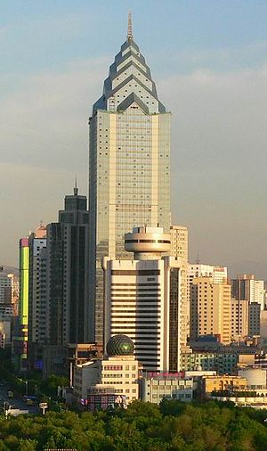
Zhong Tian Plaza
Building in Xinjiang, China
Distance: Approx. 2314 meters
Latitude and longitude: 43.7986,87.6055
China CITIC Bank Mansion (Chinese: 中信银行大厦), formerly Zhong Tian Plaza (Chinese: 中天广场) is a 59-floor/229-meter tall skyscraper in Ürümqi, Xinjiang, People's Republic of China.

Hongshan Arena
Sports venue in Ürümqi, China
Distance: Approx. 2040 meters
Latitude and longitude: 43.80865,87.60854
Hongshan Arena is an indoor sporting arena located in Ürümqi, Xinjiang, China. The capacity of the arena is 3,800 spectators and opened in 2002. It hosts indoor sporting events such as basketball and volleyball.
People's Park (Ürümqi)
Urban public park in Ürümqi, Xinjiang, China
Distance: Approx. 2211 meters
Latitude and longitude: 43.79704,87.60154
People's Park (Chinese: 人民公园; pinyin: Rénmín Gōngyuán) is an urban public park in the center of Ürümqi, the capital of Xinjiang Uyghur Autonomous Region in northwestern China. People's Park and the nearby Hong Shan are very popular recreation areas for local residents. The Xinjiang Uyghur Museum was formerly located in the park.

May 2014 Ürümqi attack
Terrorist bombing in Xinjiang, China
Distance: Approx. 2321 meters
Latitude and longitude: 43.79361111,87.59694444
On the morning of 22 May 2014, two sport utility vehicles (SUVs) carrying five assailants were driven into a busy street market in Ürümqi, the capital of China's Xinjiang Uyghur Autonomous Region. Up to a dozen explosives were thrown at shoppers from the windows of the SUVs. The SUVs crashed into shoppers, then collided with each other and exploded.
Xinjiang Normal University
University in Ürümqi, Xinjiang Uyghur Autonomous Region, China
Distance: Approx. 2237 meters
Latitude and longitude: 43.83165,87.59007
Xinjiang Normal University (XJNU) (Uyghur: شىنجاڭ پىداگوگېكا ئۇنىۋېرسىتېتى; Chinese: 新疆师范大学; pinyin: Xīnjiāng Shīfàn Dàxué) is a public university in the Xinjiang Uyghur Autonomous Region of the People's Republic of China, which was established in December 1978 with the approval of the Ministry of Education, and its predecessors were Ürümqi First Normal School and Xinjiang Teacher Training Department.

Xinjiang Museum
National Museum in Ürümqi, Xinjiang Uyghur Autonomous Region, China
Distance: Approx. 828 meters
Latitude and longitude: 43.81953333,87.58396944
The Xinjiang Uyghur Autonomous Region Museum, or Xinjiang Museum, is located in Urumqi, Xinjiang, China. Its address is 581 Xibei Road, Urumqi. The museum holds over 40,000 items of various cultural relics and specimens, including 381 national first-grade cultural relics (国家一级文物).
Weather in this IP's area
clear sky
10 Celsius
10 Celsius
10 Celsius
10 Celsius
1025 hPa
46 %
1025 hPa
928 hPa
10000 meters
1 m/s
05:53:29
18:13:31