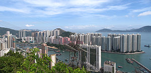
Country:
 Hong Kong (China)
Region:
City:
Latitude and Longitude:
Time Zone:
Postal Code:
IP information under different IP Channel
ip-api
Country
Region
City
ASN
Time Zone
ISP
Blacklist
Proxy
Latitude
Longitude
Postal
Route
IPinfo
Country
Region
City
ASN
Time Zone
ISP
Blacklist
Proxy
Latitude
Longitude
Postal
Route
MaxMind
Country
Region
City
ASN
Time Zone
ISP
Blacklist
Proxy
Latitude
Longitude
Postal
Route
Luminati
Country
HKASN
Time Zone
Asia/Hong_Kong
ISP
CNSERVERS
Latitude
Longitude
Postal
db-ip
Country
Region
City
ASN
Time Zone
ISP
Blacklist
Proxy
Latitude
Longitude
Postal
Route
ipdata
Country
Region
City
ASN
Time Zone
ISP
Blacklist
Proxy
Latitude
Longitude
Postal
Route
Popular places and events near this IP address

Southern District, Hong Kong
District in Hong Kong
Distance: Approx. 389 meters
Latitude and longitude: 22.24725,114.15884
The Southern District is one of the 18 districts of Hong Kong. It is located in the southern part of Hong Kong Island and the largest part of the island. It had a population of 274,994 in 2016.

Ap Lei Chau
Island in Hong Kong
Distance: Approx. 319 meters
Latitude and longitude: 22.24166667,114.15555556
Ap Lei Chau or Aberdeen Island is an island of Hong Kong, located off Hong Kong Island next to Aberdeen Harbour and Aberdeen Channel. It has an area of 1.30 square kilometres (0.50 sq mi) after land reclamation. Administratively it is part of the Southern District.

Ap Lei Chau Bridge
Bridge in Aberdeen, Hong Kong
Distance: Approx. 359 meters
Latitude and longitude: 22.24583333,114.16
Ap Lei Chau Bridge is a highway bridge in Hong Kong connecting the island of Ap Lei Chau (Aberdeen Island) to the community of Aberdeen on Hong Kong Island.

Aberdeen Promenade
Waterfront park in Aberdeen, Hong Kong
Distance: Approx. 445 meters
Latitude and longitude: 22.2473,114.15428
Aberdeen Promenade (Chinese: 香港仔海濱公園) is a small urban waterfront park in Aberdeen, Hong Kong. It is located on the north shore of Aberdeen Bay across from Aberdeen Island.

Lei Tung station
MTR station on Ap Lei Chau, Hong Kong
Distance: Approx. 248 meters
Latitude and longitude: 22.2421,114.1562
Lei Tung (Chinese: 利東; Cantonese Yale: Leihdūng) is an underground MTR rapid transit station in Hong Kong on the eastern section of the South Island line, located beside Mount Johnston on Ap Lei Chau in Southern District. The station is named after the adjacent public housing estate of the same name, which it serves in addition to Ap Lei Chau Main Street. The station is located below Yue On Court and Lei Tung Estate.

Sham Wan Towers
Housing estate in Ap Lei Chau, Hong Kong
Distance: Approx. 169 meters
Latitude and longitude: 22.243688,114.158543
The Sham Wan Towers (Chinese: 深灣軒) is a residential high-rise development located in the Ap Lei Chau area of Hong Kong. The complex consists of three towers, each of which rank among the tallest buildings in the city. The towers, numbered 1, 2, and 3, each rise 180 metres (591 ft), but differ in floor counts; Towers 1 and 2 contain 52 floors, while Tower 3 has 53.
Aberdeen Typhoon Shelters
Typhoon shelters in Hong Kong
Distance: Approx. 397 meters
Latitude and longitude: 22.246025,114.153693
The Aberdeen Typhoon Shelters of Hong Kong are Aberdeen West Typhoon Shelter (Chinese: 香港仔西避風塘) and Aberdeen South Typhoon Shelter (香港仔南避風塘). Both typhoon shelters are located in Southern District, between the southern part of Hong Kong Island and the island Ap Lei Chau. They are roughly separated by the Ap Lei Chau Bridge and Aberdeen Channel Bridge.
Hong Kong True Light College
Primary and secondary school for girls in Hong Kong
Distance: Approx. 209 meters
Latitude and longitude: 22.24286722,114.15843045
Hong Kong True Light College (HKTLC; Chinese: 香港真光書院) is a Christian girls secondary school in Ap Lei Chau, Hong Kong Island, Hong Kong.

Southern District Council
District council in Hong Kong
Distance: Approx. 412 meters
Latitude and longitude: 22.2474,114.159
Southern District Council is the district council for the Southern District in Hong Kong. It is one of 18 such councils. The Southern District Council currently consists of 20 members, of which the district is divided into two constituencies, electing a total of 4 members, 8 district committee members, and 8 appointed members.

Aberdeen Baptist Lui Ming Choi College
Distance: Approx. 265 meters
Latitude and longitude: 22.2422,114.1556
Aberdeen Baptist Lui Ming Choi College (abbreviated as ABLMCC, Chinese: 香港仔浸信會呂明才書院 or abbreviated as 浸中) is a Baptist co-educational government aided secondary school in Ap Lei Chau, Southern District, Hong Kong near Lei Tung station.

Aberdeen Channel Bridge
Bridge in Lei Tung station and Wong Chuk Hang station
Distance: Approx. 330 meters
Latitude and longitude: 22.245456,114.159902
The Aberdeen Channel Bridge (Chinese: 香港仔海峽大橋) is a double-track railway bridge in Hong Kong. It carries the MTR's South Island line over the Aberdeen Channel, linking Lei Tung station and Wong Chuk Hang station. Its name reflects the channel the bridge crosses.

Staunton Creek Nullah
Distance: Approx. 396 meters
Latitude and longitude: 22.2463,114.1601
Staunton Creek Nullah (Chinese: 黃竹坑明渠) is a nullah in Hong Kong, located in Wong Chuk Hang, in the Southern District of Hong Kong Island. The stream is in the east of the valley near Mount Cameron starting from Aberdeen Sports Ground as an artificial open channel, flowing along Heung Yip Road at Aberdeen Typhoon Shelter (Aberdeen Channel).
Weather in this IP's area
clear sky
29 Celsius
35 Celsius
28 Celsius
29 Celsius
1016 hPa
80 %
1016 hPa
1016 hPa
10000 meters
0.45 m/s
1.34 m/s
327 degree
5 %
06:21:05
17:55:15