Country:
Region:
City:
Latitude and Longitude:
Time Zone:
Postal Code:
IP information under different IP Channel
ip-api
Country
Region
City
ASN
Time Zone
ISP
Blacklist
Proxy
Latitude
Longitude
Postal
Route
Luminati
Country
ASN
Time Zone
Asia/Jakarta
ISP
PT Surabaya Industrial Estate Rungkut
Latitude
Longitude
Postal
IPinfo
Country
Region
City
ASN
Time Zone
ISP
Blacklist
Proxy
Latitude
Longitude
Postal
Route
db-ip
Country
Region
City
ASN
Time Zone
ISP
Blacklist
Proxy
Latitude
Longitude
Postal
Route
ipdata
Country
Region
City
ASN
Time Zone
ISP
Blacklist
Proxy
Latitude
Longitude
Postal
Route
Popular places and events near this IP address
University of Surabaya
Distance: Approx. 1737 meters
Latitude and longitude: -7.3198009,112.7681119
University of Surabaya (UBAYA) is a university in Rungkut, Surabaya, East Java, Indonesia. UBAYA is the successor to Trisakti University of Surabaya which was founded in 1966. Its name was changed to the University of Surabaya in 1968.
Petra Christian University
Private university located in Surabaya, Indonesia.
Distance: Approx. 2418 meters
Latitude and longitude: -7.33947222,112.73752778
Petra Christian University, commonly abbreviated as PCU (Indonesian: Universitas Kristen Petra) is a major private Christian university the oldest and largest in Indonesia, located in Wonocolo District in Surabaya, East Java - Indonesia. It was established in 1961, founded by PPPK Petra, an educational Christian based in Surabaya which established in 1951. The Petra name itself is taken from the Greek language that translates as coral reef or rock.
Graha Pena
Office in Surabaya , Indonesia
Distance: Approx. 3217 meters
Latitude and longitude: -7.32,112.731388
Graha Pena is a skyscraper building in Surabaya. It is one of the tallest buildings and is located at the south part of Surabaya. It has a height of 175 m.
National Development University "Veteran" of East Java
Distance: Approx. 3386 meters
Latitude and longitude: -7.33361111,112.78861111
The National Development University "Veteran" of East Java (Indonesian: Universitas Pembangunan Nasional "Veteran" Jawa Timur) is a public university located in Surabaya, East Java, Indonesia which was established on July 5, 1959. UPN "Veteran" in East Java is a very large institution with 20,000 students from various provinces in Indonesia as well as foreign students. UPN “Veteran” in East Java was founded by veterans of freedom fighters as a living monument to the development of education in Indonesia.

DBL Arena
Indoor sporting arena
Distance: Approx. 3112 meters
Latitude and longitude: -7.3205,112.7322
The DBL Arena is an indoor sporting arena located in Surabaya, East Java, Indonesia. Located in the suburb of Surabaya, adjacent to the Graha Pena Building, it is renowned as one of the Indonesia's main venue for basketball matches. It is also home for the Development Basketball League, a basketball competition between junior and senior high schools formerly named DetEksi Basketball League (DBL).
Waru, Sidoarjo
District in East Java, Indonesia
Distance: Approx. 2468 meters
Latitude and longitude: -7.3511436,112.7688416
Waru is an administrative district (kecamatan) in Sidoarjo Regency, in the East Java Province of Indonesia. It is situated immediately south of the city of Surabaya, of which it is a suburb. The Purabaya bus station is located in this district.
Sunan Ampel State Islamic University Surabaya
State Islamic university in Surabaya, East Java, Indonesia
Distance: Approx. 2824 meters
Latitude and longitude: -7.32233,112.734251
Sunan Ampel State Islamic University Surabaya, also abbreviated as UIN Sunan Ampel (formerly IAIN Sunan Ampel), is one of the state Islamic universities in Indonesia based in Surabaya which organizes multidisciplinary Islamic education as well as secular education including science and technology. The university has history of cultivating the intellectual background for Islamic movements and organizations, especially for Nahdlatul Ulama. UIN Surabaya is named after Sunan Ampel, one of Wali Sanga, the legendary Sufi figures who greatly contributed to the spread of Islam in Indonesia.
Siantar Top
Indonesian snacks company
Distance: Approx. 3388 meters
Latitude and longitude: -7.358366,112.772894
Siantar Top is an Indonesian snacks and consumer goods company based in Sidoarjo, East Java.

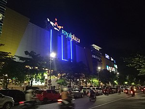
Royal Plaza (Surabaya)
Shopping mall in Surabaya, Indonesia
Distance: Approx. 3614 meters
Latitude and longitude: -7.3091953,112.7344606
Royal Plaza is a shopping center located in Surabaya, East Java. The shopping mall was founded on October 7, 2006. The mall consists of 4 floors with notable tenants namely Matahari Dept.
Avian Tower
Skyscraper in Surabaya, Indonesia
Distance: Approx. 3290 meters
Latitude and longitude: -7.34299019,112.73043844
Avian Tower is a high-rise building located in Surabaya, Indonesia. It serves as the headquarters of Avian Brands The Tower is 84 meters tall, with 20 stories. The tower is a twisted tower, the floor rotates an average 3°, and the tower itself rotate 60°.

Kertomenanggal railway station
Railway station in Indonesia
Distance: Approx. 3295 meters
Latitude and longitude: -7.340578,112.729508
Kertomenanggal Station (KTL) is an inactive railway station located in Menanggal, Gayungan, Surabaya. This station is included in the Operation Area VIII Surabaya and is a railway station that is located in the southernmost city of Surabaya. This station is 1.2 km (0.75 mi) from Waru Station to the north, to be precise near the Surabaya Golkar Building.

Jemursari railway station
Railway station in Indonesia
Distance: Approx. 2993 meters
Latitude and longitude: -7.32937,112.731
Jemursari Station (JMS) is an inactive railway station located on the border of Jemur Wonosari and Gayungan. This station was included in the Operation Area VIII Surabaya, to be precise 3 kilometres (1.9 mi) from Wonokromo Station to the south and 2.5 kilometres (1.6 mi) from Waru Station to the north. Jemursari Station was one of the first railway stations in the city of Surabaya which was built in 2003–2004 during the launch of the Delta Ekspres service for the Surabaya–Sidoarjo connection.
Weather in this IP's area
few clouds
33 Celsius
40 Celsius
33 Celsius
36 Celsius
1009 hPa
62 %
1009 hPa
1009 hPa
8000 meters
4.12 m/s
40 degree
20 %
05:00:16
17:27:05