103.218.168.196 - IP Lookup: Free IP Address Lookup, Postal Code Lookup, IP Location Lookup, IP ASN, Public IP
Country:
Region:
City:
Location:
Time Zone:
Postal Code:
IP information under different IP Channel
ip-api
Country
Region
City
ASN
Time Zone
ISP
Blacklist
Proxy
Latitude
Longitude
Postal
Route
Luminati
Country
Region
wb
City
kolkata
ASN
Time Zone
Asia/Kolkata
ISP
Alliance Broadband Services Pvt. Ltd.
Latitude
Longitude
Postal
IPinfo
Country
Region
City
ASN
Time Zone
ISP
Blacklist
Proxy
Latitude
Longitude
Postal
Route
IP2Location
103.218.168.196Country
Region
uttar pradesh
City
varanasi
Time Zone
Asia/Kolkata
ISP
Language
User-Agent
Latitude
Longitude
Postal
db-ip
Country
Region
City
ASN
Time Zone
ISP
Blacklist
Proxy
Latitude
Longitude
Postal
Route
ipdata
Country
Region
City
ASN
Time Zone
ISP
Blacklist
Proxy
Latitude
Longitude
Postal
Route
Popular places and events near this IP address

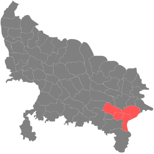
Varanasi division
Administrative division of Uttar Pradesh, India
Distance: Approx. 1790 meters
Latitude and longitude: 25.32,83.01
Varanasi division is one of the 18 administrative geographical units (i.e. division) of the northern Indian state of Uttar Pradesh. Varanasi city is the administrative headquarters of the division.

Varanasi district
District in Uttar Pradesh, India
Distance: Approx. 4 meters
Latitude and longitude: 25.33333333,83
Varanasi district is a district in the Indian state of Uttar Pradesh, with the holy city of Varanasi as the district headquarters. It is also the headquarters of the Varanasi division which contains 4 districts (including Varanasi). It is surrounded by Mirzapur district, Jaunpur district, Ghazipur district, Chandauli district, and Bhadohi district.
Sampurnanand Sanskrit Vishwavidyalaya
Indian university in Varanasi, Uttar Pradesh
Distance: Approx. 339 meters
Latitude and longitude: 25.3327,82.9967
Sampurnanand Sanskrit Vishwavidyalaya (IAST: Sampūrṇānand Saṃskṛta Viśvavidyālaya, Vāraṇāsī; formerly Varanaseya Sanskrit Vishwavidyalaya and Government Sanskrit College, Varanasi) is an Indian university and institution of higher learning located in Varanasi, Uttar Pradesh. It is one of the largest Sanskrit universities in the world. Currently university offers a range of undergraduate and postgraduate programs in various disciplines.

Varanasi Lok Sabha constituency
Constituency of the Indian parliament in Uttar Pradesh
Distance: Approx. 1790 meters
Latitude and longitude: 25.32,82.99
Varanasi Lok Sabha constituency is one of the 80 Lok Sabha constituencies in the Uttar Pradesh state in India. Narendra Modi has been elected thrice from this constituency to become the Prime Minister of India. His party, the Bharatiya Janata Party (BJP), is the most successful in Varanasi, having won a total of 8 terms since the constituency was established in 1952.

Roman Catholic Diocese of Varanasi
Roman Catholic diocese in Uttar Pradesh, India
Distance: Approx. 1607 meters
Latitude and longitude: 25.3312,82.9842
The Roman Catholic Diocese of Varanasi (Latin: Varanasien[sis]) is a Latin suffragan diocese in the ecclesiastical province of Agra in northern India's vast state Uttar Pradesh. Its cathedral episcopal see is St. Mary's Cathedral in the city of Varanasi.

Varanasi Junction railway station
Railway junction station in Varanasi, Uttar Pradesh, India.
Distance: Approx. 1541 meters
Latitude and longitude: 25.32694444,82.98638889
Varanasi Junction railway station (station code: BSB), also known as Varanasi Cantt railway station, is the main railway station serving the city of Varanasi. The other key railway stations in Varanasi Metro area are Banaras, Varanasi City, Kashi and Pandit Deen Dayal Upadhyaya Junction. The junction station is sandwiched between the cantonment region and Chetganj region of the city.

Kabir Chaura
Distance: Approx. 1685 meters
Latitude and longitude: 25.32,83.008
Kabir Chaura is a locality in Varanasi, India. It is known as the place where the great mystic poet and saint Kabir grew up. The word 'Chaura' is a distortion of 'Chauraha', literally meaning a four-way crossing (chau meaning "four"; raha meaning "way").
DAV Post Graduate College
College in Uttar Pradesh, India
Distance: Approx. 1485 meters
Latitude and longitude: 25.3228,83.0091
DAV Post Graduate College, also known as DAV Degree College is a college in Ausanganj, Varanasi, Uttar Pradesh, India, admitted to the privileges of Banaras Hindu University and recognised by University Grants Commission. The college was awarded the A+ Grade by NAAC in 2023. It is one of the top colleges in India with A+ rating by NAAC. It was established in 1938 by Pandit Ram Narayan Mishra and Shri Gauri Shankar Prasad.
Harish Chandra Postgraduate College
College in Varanasi, India
Distance: Approx. 1949 meters
Latitude and longitude: 25.319826,83.012362
Harish Chandra Postgraduate College is a government college and one of the oldest colleges in Maidagin, Varanasi, India. A government college that offers undergraduate and postgraduate. The Ph.D. degree programs are running in most of the departments.
Varanasi Graduates constituency
Distance: Approx. 1574 meters
Latitude and longitude: 25.327,82.986
Varanasi Graduates constituency is one of a hundred Legislative Council seats in Uttar Pradesh. This constituency covers Varanasi, Mirzapur, Ghazipur, Ballia, Chandauli, Sant Ravidas Nagar and Sonebhadra districts.
Prince of Wales Hospital (Benares)
Hospital in British, India
Distance: Approx. 1725 meters
Latitude and longitude: 25.32003504,83.00886562
The Prince of Wales Hospital was a hospital in Benares, British India, built to celebrate the visit to Benares in 1876–77, of the Prince of Wales, who later became his Majesty King Edward VII. The hospital was opened by Lord Ripon in 1877. Initially it consisted of one operating theatre and eight wards. Private residents could stay in accompanying accommodation.
National School of Drama, Varanasi
Distance: Approx. 1423 meters
Latitude and longitude: 25.321712,83.005976
National School of Drama, Varanasi is a new extension center of National School of Drama, New Delhi, established in 2018 to provide one-year training on Indian Classical Theatre and Natyashashtra. It is an autonomous institution under the Ministry of Culture, Government of India.
Weather in this IP's area
haze
12 Celsius
11 Celsius
12 Celsius
12 Celsius
1016 hPa
71 %
1016 hPa
1007 hPa
1500 meters
4.12 m/s
260 degree