103.218.121.64 - IP Lookup: Free IP Address Lookup, Postal Code Lookup, IP Location Lookup, IP ASN, Public IP
Country:
Region:
City:
Location:
Time Zone:
Postal Code:
IP information under different IP Channel
ip-api
Country
Region
City
ASN
Time Zone
ISP
Blacklist
Proxy
Latitude
Longitude
Postal
Route
Luminati
Country
Region
c
City
dhaka
ASN
Time Zone
Asia/Dhaka
ISP
RAJOR ONLINE COMMUNICATION
Latitude
Longitude
Postal
IPinfo
Country
Region
City
ASN
Time Zone
ISP
Blacklist
Proxy
Latitude
Longitude
Postal
Route
IP2Location
103.218.121.64Country
Region
dhaka
City
kishorganj
Time Zone
Asia/Dhaka
ISP
Language
User-Agent
Latitude
Longitude
Postal
db-ip
Country
Region
City
ASN
Time Zone
ISP
Blacklist
Proxy
Latitude
Longitude
Postal
Route
ipdata
Country
Region
City
ASN
Time Zone
ISP
Blacklist
Proxy
Latitude
Longitude
Postal
Route
Popular places and events near this IP address

Kishoreganj District
District in Dhaka Division, Bangladesh
Distance: Approx. 1686 meters
Latitude and longitude: 24.43333333,90.78333333
Kishoreganj District (Bengali: কিশোরগঞ্জ জেলা) is a district in Dhaka Division, Bangladesh. Earlier it was a mahakuma (sub-division) under Mymensingh district. 2495.07 km2 of land was taken from Mymensingh district to form Kishoreganj District.

Kishoreganj
City in Kishoreganj District, Dhaka Division, Bangladesh
Distance: Approx. 1141 meters
Latitude and longitude: 24.4385,90.7764
Kishoreganj is a city and the headquarters of Kishoreganj District in the division of Dhaka, Bangladesh. The city is divided two sides by the Narasundha River. The city is notable for its preserved cultural heritage sites.

Kishoreganj Sadar Upazila
Upazila in Dhaka Division, Bangladesh
Distance: Approx. 1686 meters
Latitude and longitude: 24.43333333,90.78333333
Kishoreganj Sadar (Bengali: কিশোরগঞ্জ সদর) is an upazila of Kishoreganj District in Dhaka Division, Bangladesh. It is best known as the home upazila of Syed Nazrul Islam, once an acting President of Bangladesh.
Kishorganj Govt. Boys' High School
Government school in Kishoreganj, Bangladesh
Distance: Approx. 1431 meters
Latitude and longitude: 24.4391,90.7793
Kishorganj Govt. Boys' High School or KGBHS (Bengali: কিশোরগঞ্জ সরকারি বালক উচ্চ বিদ্যালয়) is a higher secondary school in Kishoreganj Sadar Upazila, Kishoreganj, Bangladesh. Established in 1881, the school has a 3.5 acres (1.4 ha) campus.
Kishoreganj Cricket Stadium
Cricket stadium located at Kishoreganj, Bangladesh
Distance: Approx. 1992 meters
Latitude and longitude: 24.44416944,90.78230833
Kishoreganj Cricket Stadium (also known as Kishoreganj New Stadium ) is located by the District Election Commission Office, Kishoreganj, Bangladesh. Mukul niketon is a popular house near the stadium.
Kishoreganj Football Stadium
Football stadium located at Kishoreganj, Bangladesh
Distance: Approx. 1452 meters
Latitude and longitude: 24.44102778,90.77823889
Kishoreganj Football Stadium (also known as Kishoreganj Old Stadium) is located by the Kishoreganj-Mymensingh Rd, Kishoreganj, Bangladesh.

Gurudayal Government College
College in Kishoreganj, Bangladesh
Distance: Approx. 1151 meters
Latitude and longitude: 24.4409,90.7744
Gurudayal Government College or Gurudayal College (Bengali: গুরুদয়াল সরকারি মহাবিদ্যালয়) is a public tertiary higher education institution. It is affiliated with the National University in Bangladesh. The college is located in Kishoreganj, Bangladesh.
Ishakha International University, Bangladesh
Private university in Kishorganj, Bangladesh
Distance: Approx. 2294 meters
Latitude and longitude: 24.44666944,90.78391944
Ishakha International University Bangladesh is a private university located in Kishorganj, Bangladesh. The government of Bangladesh approved its establishment in 2012 under the Private University Act (PUA) 1992 (now replaced by PUA 2010). Financial support came from the United Group, a Bangladeshi business conglomerate.

Kishoreganj-1
Constituency of Bangladesh's Jatiya Sangsad
Distance: Approx. 2296 meters
Latitude and longitude: 24.45,90.78
Kishoreganj-1 is a constituency represented in the Jatiya Sangsad (National Parliament) of Bangladesh from 2008 to 2018 by Sayed Ashraful Islam of the Awami League. His death in January 2019, days after his re-election, will trigger a by-election.
Bangabandhu Sheikh Mujibur Rahman University, Kishoreganj
Bangladeshi public university
Distance: Approx. 1276 meters
Latitude and longitude: 24.4415,90.7755
Bangabandhu Sheikh Mujibur Rahman University, Kishoreganj (Bengali: বঙ্গবন্ধু শেখ মুজিবুর রহমান বিশ্ববিদ্যালয়) is a government financed public university located in the town of Kishoreganj in Bangladesh. Established in 2020, BSMRU is named after Bangabandhu Sheikh Mujibur Rahman, the country's founding father. On 24 January 2020 in regular cabinet meeting, chaired by prime minister, agreed in principle to the Acts for the Bangabandhu Sheikh Mujibur Rahman University in Kishoreganj District.

Shahidi Mosque
Mosque in Kishoregonj, Bangladesh
Distance: Approx. 1837 meters
Latitude and longitude: 24.4342,90.7848
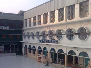
Shahidi Masjid (Bengali: শহীদী মসজিদ, Arabic: المسجد الشهيدي) is a three-storey mosque of Kishoreganj District, Bangladesh. It has a 5-storey minaret attached to it.
Kishoreganj railway station
Distance: Approx. 2351 meters
Latitude and longitude: 24.426419,90.7886273
Kishoreganj railway station is a railway station in Kishoreganj. The station is located on Mymensingh–Gouripur–Bhairab line.
Weather in this IP's area
overcast clouds
21 Celsius
20 Celsius
21 Celsius
21 Celsius
1016 hPa
35 %
1016 hPa
1014 hPa
10000 meters
1.41 m/s
1.49 m/s
288 degree
100 %