103.217.242.178 - IP Lookup: Free IP Address Lookup, Postal Code Lookup, IP Location Lookup, IP ASN, Public IP
Country:
Region:
City:
Location:
Time Zone:
Postal Code:
ISP:
ASN:
language:
User-Agent:
Proxy IP:
Blacklist:
IP information under different IP Channel
ip-api
Country
Region
City
ASN
Time Zone
ISP
Blacklist
Proxy
Latitude
Longitude
Postal
Route
db-ip
Country
Region
City
ASN
Time Zone
ISP
Blacklist
Proxy
Latitude
Longitude
Postal
Route
IPinfo
Country
Region
City
ASN
Time Zone
ISP
Blacklist
Proxy
Latitude
Longitude
Postal
Route
IP2Location
103.217.242.178Country
Region
west bengal
City
mankur
Time Zone
Asia/Kolkata
ISP
Language
User-Agent
Latitude
Longitude
Postal
ipdata
Country
Region
City
ASN
Time Zone
ISP
Blacklist
Proxy
Latitude
Longitude
Postal
Route
Popular places and events near this IP address

Panagarh
Village in West Bengal, India
Distance: Approx. 9294 meters
Latitude and longitude: 23.4484,87.4694
Panagarh is an industrial town and an Indian Air Force base in the Durgapur subdivision of the Paschim Bardhaman district in the Indian state of West Bengal.
Sukdal
Census Town in West Bengal, India
Distance: Approx. 3103 meters
Latitude and longitude: 23.397922,87.557149
Sukdal is a census town in Galsi I CD Block in Bardhaman Sadar North subdivision of Purba Bardhaman district in the Indian state of West Bengal.
Bud Bud
Census Town in West Bengal, India
Distance: Approx. 2431 meters
Latitude and longitude: 23.408319,87.54273
Bud Bud is a census town in Galsi I CD Block of Bardhaman Sadar North subdivision of Purba Bardhaman district in the Indian state of West Bengal.
Bardhaman–Durgapur Lok Sabha constituency
Lok Sabha constituency in West Bengal
Distance: Approx. 5248 meters
Latitude and longitude: 23.4,87.6
Bardhaman–Durgapur Lok Sabha constituency is one of the 543 parliamentary constituencies in India. The constituency is spread across Paschim Bardhaman district and Purba Bardhaman district in West Bengal. While five of the assembly seats of Bardhaman–Durgapur Lok Sabha constituency are in Purba Bardhaman district, two assembly segment is in Paschim Bardhaman district.
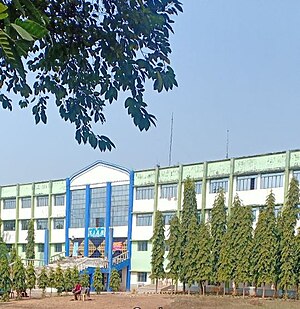
Mankar College
Distance: Approx. 1062 meters
Latitude and longitude: 23.4348893,87.5538469
Mankar College, established in 1987, is a general degree college in Mankar, Purba Bardhaman district, West Bengal. It offers undergraduate courses in arts, commerce and science, and graduate course in Bengali. There are five languages taught: English, Bengali, Sanskrit, Hindi & Santali.
Kasba, Bardhaman
Village in West Bengal, India
Distance: Approx. 9259 meters
Latitude and longitude: 23.3513,87.5167
Kasba is a village in Galsi I CD block in Bardhaman Sadar North subdivision of Purba Bardhaman district in the Indian state of West Bengal. It is situated 12.7 km away from sub-district headquarters in Galsi. Bardhaman is the district headquarter of Kasba village.
Jamtara, Bardhaman
Village in West Bengal, India
Distance: Approx. 4790 meters
Latitude and longitude: 23.435319,87.60273
Jamtara is a village located in the Ausgram II CD Block in Bardhaman Sadar North subdivision of the Purba Bardhaman district, in West Bengal, India.
Amrargar
Village in West Bengal, India
Distance: Approx. 2789 meters
Latitude and longitude: 23.43072222,87.58377778
Amarargar (more appropriately Amragarh, as per the Bengali spelling) is a village in Ausgram II CD block in Bardhaman Sadar North subdivision of Purba Bardhaman district in the state of West Bengal, India.

Mankar
Village in West Bengal, India
Distance: Approx. 1146 meters
Latitude and longitude: 23.435319,87.55273
Mankar is a village in Galsi I CD Block in Bardhaman Sadar North subdivision of Purba Bardhaman district in the state of West Bengal, India.
Camellia Institute of Engineering & Technology
College in West Bengal, India
Distance: Approx. 2089 meters
Latitude and longitude: 23.407275,87.55373889
Camellia Institute of Engineering & Technology, commonly known as CIET, is a technical degree college located in Bud Bud, Purba Bardhaman in the Indian state of West Bengal.

Kanad Institute of Engineering and Management
College in West Bengal, India
Distance: Approx. 1409 meters
Latitude and longitude: 23.43388889,87.54638889
Kanad Institute of Engineering and Management abbreviated as KIEM is a private engineering institution in West Bengal, India which offers undergraduate (B.Tech) four-year engineering degree courses in five disciplines. The college is affiliated to Maulana Abul Kalam Azad University of Technology (MAKAUT).
Raipur, Purba Bardhaman
Census Town in West Bengal, India
Distance: Approx. 1682 meters
Latitude and longitude: 23.4183,87.5427
Raipur is a census town in Galsi I CD Block in Bardhaman Sadar North subdivision of Purba Bardhaman district in the Indian state of West Bengal.
Weather in this IP's area
clear sky
15 Celsius
14 Celsius
15 Celsius
15 Celsius
1013 hPa
57 %
1013 hPa
1007 hPa
10000 meters
0.87 m/s
0.94 m/s
303 degree