Country:
 India
IndiaRegion:
City:
Latitude and Longitude:
Time Zone:
Postal Code:
IP information under different IP Channel
ip-api
Country
Region
City
ASN
Time Zone
ISP
Blacklist
Proxy
Latitude
Longitude
Postal
Route
IPinfo
Country
Region
City
ASN
Time Zone
ISP
Blacklist
Proxy
Latitude
Longitude
Postal
Route
MaxMind
Country
Region
City
ASN
Time Zone
ISP
Blacklist
Proxy
Latitude
Longitude
Postal
Route
Luminati
Country
INRegion
hr
City
panipat
ASN
Time Zone
Asia/Kolkata
ISP
Gigantic Infotel Pvt Ltd
Latitude
Longitude
Postal
db-ip
Country
Region
City
ASN
Time Zone
ISP
Blacklist
Proxy
Latitude
Longitude
Postal
Route
ipdata
Country
Region
City
ASN
Time Zone
ISP
Blacklist
Proxy
Latitude
Longitude
Postal
Route
Popular places and events near this IP address

First Battle of Panipat
1526 battle during the Mughal conquest of the Delhi Sultanate
Distance: Approx. 1736 meters
Latitude and longitude: 29.40305556,76.97333333
The First Battle of Panipat, on 21 April 1526 was fought between the invading forces of Babur and Ibrahim Lodi of the Lodi dynasty. It took place in North India and marked the beginning of the Mughal Empire and the end of the Delhi Sultanate. This was one of the earliest battles involving gunpowder firearms and field artillery in the Indian subcontinent which were introduced by the Mughals in this battle.

Panipat
City in Haryana, India
Distance: Approx. 321 meters
Latitude and longitude: 29.3875,76.97
Panipat (Hindi pronunciation: [päː.niː.pɐt̪] ) is an industrial planned city, located in Haryana, India. It is 95 km north of Delhi and 169 km south of Chandigarh on NH-1. The three major battles fought in 1526, 1556 and 1761 took place near the city.

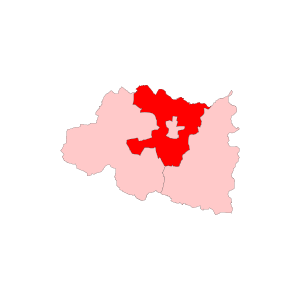
Panipat district
District of Haryana in India
Distance: Approx. 344 meters
Latitude and longitude: 29.39,76.97
Panipat district () is one of the 22 districts of Haryana in north India. The historical city of Panipat is the administrative headquarters of the district. The district occupies an area of 1,268 km2 (490 sq mi), making it the nineteenth largest in the state with Gurugram and Panchkula following it.
Navdeep Hospital and Emergency Care
Distance: Approx. 1352 meters
Latitude and longitude: 29.3992485,76.9733937
Navdeep Hospital, Hair transplant & Laser Clinic is a private, multispeciality hospital in Panipat, India. It is located in 112, Sukhdev Nagar, Panipat. The hospital, which is named after Dr Navdeep Goyal, was established in 2009 to provide medical care to natives of Panipat and nearby districts.

Panipat Junction railway station
Railway station in Haryana, India
Distance: Approx. 287 meters
Latitude and longitude: 29.389,76.964
Panipat Junction Railway Station (station code: PNP) is located in Panipat district in the Indian state of Haryana and serves the historic and industrial town of Panipat.
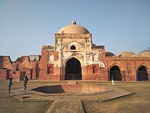
Kabuli Bagh Mosque
Mosque in Haryana, India
Distance: Approx. 2305 meters
Latitude and longitude: 29.395804,76.989137
The Kabuli Bagh Mosque is a mosque in Panipat, Haryana, India which was built in 1527 by the emperor Babur to mark his victory over Sultan Ibrahim Lodhi at the first Battle of Panipat in 1526. The mosque is named after Kabuli Begum, Babur's wife.
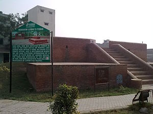
Tomb of Ibrahim Lodi
Distance: Approx. 344 meters
Latitude and longitude: 29.39,76.97
The Tomb of Ibrahim Lodi in Panipat (Haryana, India) is the tomb of Ibrahim Lodi, Sultan of the Lodi dynasty.

Hemu's Samadhi Sthal
Distance: Approx. 344 meters
Latitude and longitude: 29.39,76.97
Hemu's Smadhi Sthal, is a memorial to the Hindu king Hemu at Shodapur village on Jind road near Panipat city in Panipat district of Haryana state in India. It stands at the location where he was executed.

Shodapur
Distance: Approx. 344 meters
Latitude and longitude: 29.39,76.97
Shodapur is a village in Panipat district of the Haryana state in India. The Second Battle of Panipat was fought on 5 November 1556 between the forces of Akbar and Hemu, a Hindu king of Delhi. In the battle, a wounded Hemu was captured by Shah Quli Khan and carried to the Mughal camp at Shodapur on Jind Road at Panipat where he was beheaded.
Panipat Rural Assembly constituency
Constituency of the Haryana legislative assembly in India
Distance: Approx. 1445 meters
Latitude and longitude: 29.4,76.96
Panipat Rural Assembly constituency is one of the 90 constituencies in the Haryana Legislative Assembly of Haryana a northern state of India. It is also part of Karnal (Lok Sabha constituency).

Panipat City Assembly constituency
Constituency of the Haryana legislative assembly in India
Distance: Approx. 1445 meters
Latitude and longitude: 29.4,76.96
Panipat City Assembly constituency is one of the 90 constituencies in the Haryana Legislative Assembly of Haryana a north state of India. Panipat City is also part of Karnal Lok Sabha constituency.
Panipat Assembly constituency
Constituency of the Haryana legislative assembly in India
Distance: Approx. 1315 meters
Latitude and longitude: 29.4,76.97
Panipat Assembly constituency was an assembly constituency in the Indian state of Haryana.
Weather in this IP's area
overcast clouds
23 Celsius
24 Celsius
23 Celsius
23 Celsius
1007 hPa
80 %
1007 hPa
980 hPa
10000 meters
2.58 m/s
5.67 m/s
10 degree
95 %
06:09:00
18:22:55