103.215.52.76 - IP Lookup: Free IP Address Lookup, Postal Code Lookup, IP Location Lookup, IP ASN, Public IP
Country:
Region:
City:
Location:
Time Zone:
Postal Code:
IP information under different IP Channel
ip-api
Country
Region
City
ASN
Time Zone
ISP
Blacklist
Proxy
Latitude
Longitude
Postal
Route
Luminati
Country
ASN
Time Zone
Asia/Kolkata
ISP
Alliance Broadband Services Pvt. Ltd.
Latitude
Longitude
Postal
IPinfo
Country
Region
City
ASN
Time Zone
ISP
Blacklist
Proxy
Latitude
Longitude
Postal
Route
IP2Location
103.215.52.76Country
Region
kerala
City
malappuram
Time Zone
Asia/Kolkata
ISP
Language
User-Agent
Latitude
Longitude
Postal
db-ip
Country
Region
City
ASN
Time Zone
ISP
Blacklist
Proxy
Latitude
Longitude
Postal
Route
ipdata
Country
Region
City
ASN
Time Zone
ISP
Blacklist
Proxy
Latitude
Longitude
Postal
Route
Popular places and events near this IP address

Malappuram district
District in Kerala, India
Distance: Approx. 4474 meters
Latitude and longitude: 11.03,76.05
Malappuram (Malayalam: [mɐlɐpːurɐm] ), is one of the 14 districts in the Indian state of Kerala, with a coastline of 70 km (43 mi). The most populous district of Kerala, Malappuram is home to around 13% of the total population of the state. The district was formed on 16 June 1969, spanning an area of about 3,554 km2 (1,372 sq mi).
Myladi, Kerala
Village in Kerala, India
Distance: Approx. 4274 meters
Latitude and longitude: 11.1,76.04722222
Myladi is a village in Kerala, India.

Malappuram
Metropolis in Kerala, India
Distance: Approx. 1813 meters
Latitude and longitude: 11.051,76.07111111
Malappuram (also Malapuram) (Malayalam: [mɐlɐpːurɐm] ) is a town in Kerala and the headquarters of the Malappuram district in Kerala, India. It is the 4th largest urban agglomeration in Kerala and the 20th largest in India, spread over an area of 158.20 km2 (61.08 sq mi) including the surrounding suburban areas. The first municipality in the district formed in 1970, Malappuram serves as the administrative headquarters of Malappuram district.

Pookkottur
Village in Kerala, India
Distance: Approx. 3412 meters
Latitude and longitude: 11.09722222,76.06388889
Pookkottoor is a village in Eranad taluk, and a suburb of Malappuram, Kerala, India. It is on National Highway 966, and there is a state road from the town to Manjeri. It was the centre of the Malabar Rebellion of 1921 that shook the British administration in the erstwhile Malabar district of Madras Province.

Kottakkunnu
Hill station in Kerala, India
Distance: Approx. 2739 meters
Latitude and longitude: 11.048,76.083
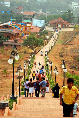
Kottakkunnu is a hill station in Malappuram district of Kerala state, India. Widely known as Kotta Kunnu, it is situated at a height of 915 metres and is a popular tourist destination in the state of Kerala located at Malappuram.
Kendriya Vidyalaya, Malappuram
Central government school in Malappuram, Kerala, India
Distance: Approx. 2866 meters
Latitude and longitude: 11.0427,76.0762
Kendriya Vidyalaya Malappuram is a school run by Kendriya Vidyalaya Sangathan located in Malappuram, Kerala. It was established in 1986.
Vadakkemanna
Distance: Approx. 3714 meters
Latitude and longitude: 11.03333333,76.06666667
Vadakkemanna is a place situated in Malappuram district of Kerala, India. It is a suburb of Malappuram.

Panakkad
Village in Kerala, India
Distance: Approx. 3503 meters
Latitude and longitude: 11.047,76.0417
Panakkad is a small town and Village in Malappuram municipality in the state of Kerala, India. It is located on the banks of Kadalundippuzha river. Panakkad Thangal family resides in this village.
College of Applied Science Malappuram
Educational institute in Kerala
Distance: Approx. 3385 meters
Latitude and longitude: 11.0568,76.096
College of Applied Science Malappuram, is established in 1993, affiliated to University of Calicut and is managed by Institute of Human Resources Development (IHRD) established by Govt. of Kerala.
Government College, Malappuram
Distance: Approx. 3251 meters
Latitude and longitude: 11.0570575,76.0947873
Government College, Malappuram, is a general degree college located in Malappuram, Kerala. It was established in 1972. The college is affiliated with Calicut University.

Battle of Pookkottur
A battle during the Malabar rebellion
Distance: Approx. 3412 meters
Latitude and longitude: 11.09722222,76.06388889
The Battle of Pookkottur was a battle that the Mappilas of Malabar fought against the British army during anti-colonial struggles in the Malabar province of Northern Kerala, India. The battle took place on 26 August 1921 at Pookkottur in Malappuram district. The Indian forces were led by Vadakkuveettil Mohammed, the Secretary of the Khilafat Committee in the Malabar region.

Alathurpadi Dars
Higher education school in Malappuram, Kerala, India
Distance: Approx. 976 meters
Latitude and longitude: 11.07153923,76.07414547
Alathurpadi Dars is an Islamic educational institution in Kerala, India, known for its preservation of traditional values while integrating modern advancements. Alathurpadi Dars boasts a century-long tradition of knowledge and excellence in academic ranks. The institution is distinguished by the numerous students who have completed their studies there and the teachers who have achieved high ranks in their respective fields.
Weather in this IP's area
mist
23 Celsius
24 Celsius
23 Celsius
23 Celsius
1010 hPa
94 %
1010 hPa
1007 hPa
3000 meters
1.54 m/s
90 degree
20 %