Country:
 Indonesia
Region:
City:
Latitude and Longitude:
Time Zone:
Postal Code:
IP information under different IP Channel
ip-api
Country
Region
City
ASN
Time Zone
ISP
Blacklist
Proxy
Latitude
Longitude
Postal
Route
IPinfo
Country
Region
City
ASN
Time Zone
ISP
Blacklist
Proxy
Latitude
Longitude
Postal
Route
MaxMind
Country
Region
City
ASN
Time Zone
ISP
Blacklist
Proxy
Latitude
Longitude
Postal
Route
Luminati
Country
IDASN
Time Zone
Asia/Jakarta
ISP
PT Bintang Komunikasi Utama
Latitude
Longitude
Postal
db-ip
Country
Region
City
ASN
Time Zone
ISP
Blacklist
Proxy
Latitude
Longitude
Postal
Route
ipdata
Country
Region
City
ASN
Time Zone
ISP
Blacklist
Proxy
Latitude
Longitude
Postal
Route
Popular places and events near this IP address
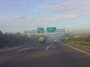
Jagorawi Toll Road
Toll road in Indonesia
Distance: Approx. 1234 meters
Latitude and longitude: -6.25305556,106.87277778
The Jakarta–Bogor–Ciawi Toll Road (shortened to Jagorawi Toll Road) is the first toll road in Indonesia. Construction of the highway began in 1973, and it was officially opened on 9 March 1978. The Jagorawi Toll Road links the capital city of Jakarta to the West Javanese cities of Bogor and Ciawi.
Makasar, Jakarta
District in East Jakarta, Indonesia
Distance: Approx. 877 meters
Latitude and longitude: -6.26666667,106.88333333
Makasar is a district (kecamatan) of East Jakarta, Indonesia. It had an area of 21.85 km2 and population of 185,830 at the 2010 Census; the latest official estimate (for mid 2019) is 204,595. The boundaries of Makasar District are Kali Malang channel to the north, Sunter River to the east, Jagorawi Toll Road to the west, and Taman Mini 2 – Pondok Gede Raya Road to the south.
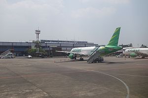
Halim Perdanakusuma International Airport
Airport in Jakarta, Java, Indonesia
Distance: Approx. 1699 meters
Latitude and longitude: -6.26638889,106.89111111
Halim Perdanakusuma International Airport (IATA: HLP, ICAO: WIHH) is an international airport in Jakarta, Indonesia. The airport is located in East Jakarta and the airfield is conjoined with the Halim Perdanakusuma air force base of the Indonesian Air Force. Aside from commercial scheduled flights, this airport is also used for military, private and presidential purposes.

Jakarta–Cikampek Toll Road
Toll Road in Indonesia
Distance: Approx. 1984 meters
Latitude and longitude: -6.24749722,106.883525
The Jakarta–Cikampek Toll Road (or Japek toll road) is a tolled expressway in Indonesia that was inaugurated in 1988. A part of the Trans-Java Toll Road network, the highway links Jakarta with cities to its east in the province of West Java. Its 36.84 kilometer-long Cikunir–West Karawang section overlaps with the Sheikh Mohammed bin Zayed Skyway.
Indonesian Masters
Golf tournament
Distance: Approx. 2957 meters
Latitude and longitude: -6.2713,106.9016
The Indonesian Masters is a golf tournament on the Asian Tour. It was first played in 2011. In 2017, the Indonesian Masters became the Asian Tour's flagship event, replacing the Thailand Golf Championship which had been the flagship event up to 2015.

2012 Indonesian Air Force Fokker F27 crash
Distance: Approx. 1838 meters
Latitude and longitude: -6.25361111,106.88916667
On 21 June 2012, a Fokker F27 military transport aircraft of the Indonesian Air Force crashed into a housing complex near Halim Airport in Jakarta, Indonesia, while conducting a training flight. All seven people on board, four people on the ground were killed and 11 more injured.

Rumah Cililitan Besar
Dutch colonial country house in Jakarta, Indonesia
Distance: Approx. 823 meters
Latitude and longitude: -6.268904,106.870743
Rumah Cililitan Besar ("Cililitan Besar House"), also known as simply Cililitan Besar or Lebak Sirih, is a former Dutch colonial country house located in Kramat Jati, Jakarta. It was known in Dutch as Landhuis Tjililitan Besar. It is located next to the complex of Soekanto Indonesian National Police Hospital.

2016 Halim Airport collision
2016 aviation incident
Distance: Approx. 1817 meters
Latitude and longitude: -6.26611667,106.89223056
The 2016 Halim Airport collision occurred when Batik Air Flight 7703, a scheduled domestic flight operated by Lion Air's subsidiary Batik Air, collided during its take-off roll with a TransNusa Air Services aircraft, which was being towed across the runway. Batik Air Flight 7703 was operating from Halim Perdanakusuma Airport in Jakarta to Sultan Hasanuddin International Airport in Makassar. On 4 April 2016, while taking off from Halim Perdanakusuma Airport, the Boeing 737-800 operating the flight (registration PK-LBS) collided with a ATR 42-600 (registration PK-TNJ).

Pasar Minggu Baru railway station
Railway station in Indonesia
Distance: Approx. 2680 meters
Latitude and longitude: -6.2628,106.8518
Pasar Minggu Baru Station (PSMB) (Indonesian: Stasiun Pasar Minggu Baru) is a railway station in East Pejaten, Pasar Minggu, South Jakarta, Indonesia. The station, which is located at an altitude of + 29 metres, is included in the Jakarta Operational Area I and only serves the KRL Commuterline route. Since 8 September 2021, this station and Universitas Pancasila Station already have a pedestrian tunnel, which facilitates access for passenger crossing, as well as being equipped with an elevator located in the middle of both sides of the platform.

Halim railway station
High-speed rail and LRT station in Indonesia
Distance: Approx. 2171 meters
Latitude and longitude: -6.2464709,106.885241
Halim Station is a railway station complex located on Makasar, East Jakarta, Jakarta, Indonesia. The complex serves the Jakarta-Bandung high-speed railway of Kereta Cepat Indonesia China (KCIC) and the Jabodebek LRT Bekasi Line of Kereta Api Indonesia (KAI). The complex consists of two separate elevated stations connected via pedestrian bridge.

Ciliwung LRT Station
Railway station in Indonesia
Distance: Approx. 2603 meters
Latitude and longitude: -6.243477,106.864131
Ciliwung LRT Station is a light rail station located in Jalan Letjen M.T. Haryono, Cawang, Kramat Jati, East Jakarta. The station, which is located at an altitude of +36.34 meters, serves the Cibubur and Bekasi lines of the Jabodebek LRT system.

Cawang LRT Station
Light rail station in Jakarta, Indonesia
Distance: Approx. 1983 meters
Latitude and longitude: -6.246225,106.872386
Cawang LRT Station is a light rail station located in Jalan Letjen M.T. Haryono, Cawang, Kramat Jati, East Jakarta. The station, which is located at an altitude of +39 meters, serves the Cibubur and Bekasi lines of the Jabodebek LRT system. It is the main interchange station between the two lines of the system where the two lines meet and split.
Weather in this IP's area
few clouds
34 Celsius
36 Celsius
33 Celsius
36 Celsius
1009 hPa
42 %
1009 hPa
1007 hPa
7000 meters
3.09 m/s
240 degree
20 %
05:29:07
17:45:07