103.210.92.170 - IP Lookup: Free IP Address Lookup, Postal Code Lookup, IP Location Lookup, IP ASN, Public IP
Country:
 India
IndiaRegion:
City:
Location:
Time Zone:
Postal Code:
ISP:
ASN:
language:
User-Agent:
Proxy IP:
Blacklist:
IP information under different IP Channel
ip-api
Country
Region
City
ASN
Time Zone
ISP
Blacklist
Proxy
Latitude
Longitude
Postal
Route
db-ip
Country
Region
City
ASN
Time Zone
ISP
Blacklist
Proxy
Latitude
Longitude
Postal
Route
IPinfo
Country
Region
City
ASN
Time Zone
ISP
Blacklist
Proxy
Latitude
Longitude
Postal
Route
IP2Location
103.210.92.170Country
inRegion
punjab
City
rajpura
Time Zone
Asia/Kolkata
ISP
Language
User-Agent
Latitude
Longitude
Postal
ipdata
Country
Region
City
ASN
Time Zone
ISP
Blacklist
Proxy
Latitude
Longitude
Postal
Route
Popular places and events near this IP address

Rajpura
City in Punjab, India
Distance: Approx. 139 meters
Latitude and longitude: 30.484,76.594
Rajpura (Punjabi pronunciation: [ɾədʒpʊɾɑː]) is a city in Patiala district in the Indian state of Punjab, India, situated along the border of the Indian state of Haryana. It is located 26 KM Patiala city, towards East from district headquarter. It is Tehsil headquarter, here the Mini-Secretariat is an administrative building that houses various government offices, including those related to the judiciary.

Chitkara University, Punjab
University in Punjab, India
Distance: Approx. 7139 meters
Latitude and longitude: 30.51638889,76.65861111
Chitkara University is a private university located in Rajpura, Punjab, India. It offers undergraduate programs, post-graduate program and doctoral programs in fields of engineering, management, pharmacy, health sciences, nursing, hospitality, art & design and education. It was established and is managed by the Chitkara Educational Trust.

Jhansla
Distance: Approx. 8187 meters
Latitude and longitude: 30.5275,76.66305556
Jhansla is a village in Punjab, India, near Banur. The Chitkara University, Punjab, the Swami Vivekanand Institute of Engineering and Technology, and the Gian Sagar Institute for Medical Studies are all in Jhansla.

Jaswan
Precolonial Indian state
Distance: Approx. 139 meters
Latitude and longitude: 30.484,76.594
Jaswan was a precolonial Indian state in modern-day Himachal Pradesh, commanded by the Jaswal Rajput clan. It was founded in 1170 AD by Raja Purab Chand, a cadet of the Katoch lineage, ancient royal family of Kangra. Its capital was Rajpura.

Rajpura Thermal Power Plant
Distance: Approx. 8302 meters
Latitude and longitude: 30.555,76.572
Rajpura Thermal Power Plant is a coal-based thermal power plant located in Nalash village near Rajpura in Patiala district in the Indian state of Punjab. The power plant is operated by the Larsen & Toubro company.
Rajpura Junction railway station
Train station in Punjab, India
Distance: Approx. 369 meters
Latitude and longitude: 30.4862,76.59365
Rajpura Junction railway station(station code: RPJ) is a railway station serving Rajpura city in Patiala district, Punjab, India. Rajpura is the administrative headquarter of Rajpura subdivision of Patiala district. This station is under the Ambala railway division of the Northern Railway Zone of Indian Railways.
Rajpura Assembly constituency
Legislative Assembly constituency in Punjab State, India
Distance: Approx. 591 meters
Latitude and longitude: 30.48,76.59
Rajpura Assembly constituency is one of the 111 Legislative Assembly constituencies of Punjab state in India. It is part of Patiala district and is unreserved.
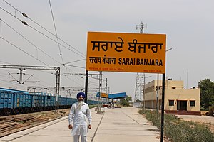
Sarai Banjara railway station
Railway station in Punjab, India
Distance: Approx. 9785 meters
Latitude and longitude: 30.538386,76.515682
Sarai Banjara railway station a railway station on Ambala–Attari line under Ambala railway division of Northern Railway zone. This is situated at Basantpura, Sarai Banjara in Patiala district in the Indian state of Punjab.
Weather in this IP's area
clear sky
12 Celsius
11 Celsius
12 Celsius
12 Celsius
1016 hPa
45 %
1016 hPa
984 hPa
10000 meters
2.56 m/s
2.56 m/s
327 degree
1 %