103.210.33.189 - IP Lookup: Free IP Address Lookup, Postal Code Lookup, IP Location Lookup, IP ASN, Public IP
Country:
 India
IndiaRegion:
City:
Location:
Time Zone:
Postal Code:
ISP:
ASN:
language:
User-Agent:
Proxy IP:
Blacklist:
IP information under different IP Channel
ip-api
Country
Region
City
ASN
Time Zone
ISP
Blacklist
Proxy
Latitude
Longitude
Postal
Route
db-ip
Country
Region
City
ASN
Time Zone
ISP
Blacklist
Proxy
Latitude
Longitude
Postal
Route
IPinfo
Country
Region
City
ASN
Time Zone
ISP
Blacklist
Proxy
Latitude
Longitude
Postal
Route
IP2Location
103.210.33.189Country
inRegion
himachal pradesh
City
dharmsala
Time Zone
Asia/Kolkata
ISP
Language
User-Agent
Latitude
Longitude
Postal
ipdata
Country
Region
City
ASN
Time Zone
ISP
Blacklist
Proxy
Latitude
Longitude
Postal
Route
Popular places and events near this IP address

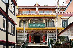
Namgyal Monastery
Tibetan Buddhist monastery in Dharamsala, Himachal Pradesh, India
Distance: Approx. 1084 meters
Latitude and longitude: 32.232521,76.324395
Namgyal Monastery (Tibetan: རྣམ་རྒྱལ།, Wylie: rnam rgyal) (also often referred to as "Dalai Lama's Temple") is in Mcleod Ganj, Dharamsala, India. It is the personal monastery of the 14th Dalai Lama. Another name for this temple-complex is Namgyal Tantric College.

Dal Lake (Himachal Pradesh)
Lake in Himachal Pradesh, India
Distance: Approx. 1155 meters
Latitude and longitude: 32.247148,76.310719
Dal Lake is a small mid-altitude lake (1,775 m above sea level) near the village of Tota Rani in Kangra district of Himachal Pradesh state in northern India. The word Dal means 'lake' in several languages of the western Himalayas. The lake is surrounded by deodar trees and is considered to be a sacred spot as there is small Shiva mandir (shrine) on its bank.

McLeod Ganj
Suburb in Kangra, Himachal Pradesh, India
Distance: Approx. 426 meters
Latitude and longitude: 32.23861111,76.32361111
McLeod Ganj or McLeodganj (pronounced ) is a suburb of Dharamshala in Kangra district, Himachal Pradesh, India. It is known as "Little Lhasa" or "Dhasa" as the Tibetan government-in-exile is headquartered here and there is a significant population of Tibetans in the region.

St. John in the Wilderness Church (Dharamshala)
Anglican church in Dharamshala, Himachal Pradesh, India
Distance: Approx. 1155 meters
Latitude and longitude: 32.247148,76.310719
St. John in the Wilderness is a Protestant church dedicated to John the Baptist. It was built in 1852 and is located near Dharamshala, India, on the way to McLeod Ganj, at Forsyth Gunj.

Gaden Choeling Nunnery
Tibetan Buddhist vihara
Distance: Approx. 792 meters
Latitude and longitude: 32.236,76.326
Ganden Choeling Nunnery or Geden Chöling (Wylie: dga' ldan chos gling dgon pa) is a Tibetan Buddhist vihara for Buddhist nuns in Dharamshala, India. It is near the monastery in which the 14th Dalai Lama resides. The Gaden Choeling Nunnery was started by nuns who fled from Nechung Ri vihara (Wylie: ne phyung ri) in Tibet, which was destroyed during the Cultural Revolution.
Library of Tibetan Works and Archives
Library
Distance: Approx. 1779 meters
Latitude and longitude: 32.2263,76.3254
The Library of Tibetan Works and Archives (LTWA) is a Tibetan library in Dharamshala, India. The library was founded by Tenzin Gyatso, the 14th Dalai Lama on 11 June 1970, and is considered one of the most important libraries and institutions of Tibetan works in the world. The library contains sources which were relocated from Tibet during the 1959 escape, including important Tibetan Buddhist manuscripts and archives related to Tibet's history, politics, culture and even art.

Dharamkot, Himachal Pradesh
Place in Himachal Pradesh, India
Distance: Approx. 440 meters
Latitude and longitude: 32.238602,76.323878
Dharamkot (aka Dharmkot) is a small hill station in Kangra district in the state of Himachal Pradesh, India. On the crest of a hill above McLeodGanj, Dharamkot is a spot with wide views of the Kangra Valley and the Dhauladhar ranges. Dharamkot also has the Vipassana meditation center, Dhamma Shikara, as well as the Tushita Meditation Centre which is a center for the study and practice of Buddhism in the Tibetan Mahayana tradition.
Kotwali Bazar
Suburb in Kangra, Himachal Pradesh, India
Distance: Approx. 2252 meters
Latitude and longitude: 32.222,76.317
Kotwali Bazar is a suburb of Dharamshala, situated at the foothills of Dhauladhar mountains, a southern branch of the main Outer Himalayan chain of mountains, in Kangra district in the Indian state of Himachal Pradesh.

Tibet Museum (Dharamshala)
Museum in Himachal Pradesh, India
Distance: Approx. 1090 meters
Latitude and longitude: 32.232587,76.324883
The Tibet Museum is the official museum of the Central Tibetan Administration's Department of Information and International Relations and is located IN CTA complex in T building , in the Dharamshala suburb of McLeod Ganj. The Tibet Museum aims to disseminate knowledge of Tibetan history and culture while raising awareness of the occupation of Tibet and the ongoing human rights abuses and environmental destruction committed by CCP China. Established in 1998, the Tibet Museum now has a collection comprising over 30,000 photographs, day to day life objects , a traveling exhibition, and a permanent exhibition that tell about Tibet idintity by telling story through culture , history and struggle.

Tibetan Delek Hospital
Hospital in Himachal Pradesh, India
Distance: Approx. 2249 meters
Latitude and longitude: 32.222,76.3172
The Tibetan Delek Hospital is a hospital founded in 1971 by members of the Tibetan diaspora and their supporters and located in Dharamshala in Northern India. It serves the Tibetan residents and local community in the region, as well as tourists from around the world. It practices social assistance, mainly using modern medicine.

Triund
Place in Himachal Pradesh, India
Distance: Approx. 1464 meters
Latitude and longitude: 32.2496,76.3339
Triund is a small hill station in the Kangra district in the state of Himachal Pradesh, India. Triund is a part of Dharamkot. Triund is at the foot of the Dhauladhar ranges and is at a height of 2,828 metres (9,278 ft).

Dharamshala Assembly constituency
Legislative Assembly constituency in Himachal Pradesh State, India
Distance: Approx. 2441 meters
Latitude and longitude: 32.22,76.32
Dharamshala Assembly constituency is one of the 68 constituencies in the Himachal Pradesh Legislative Assembly of Himachal Pradesh a northern state of India. Dharamshala is also part of Kangra Lok Sabha constituency.
Weather in this IP's area
broken clouds
8 Celsius
6 Celsius
8 Celsius
8 Celsius
1018 hPa
36 %
1018 hPa
805 hPa
10000 meters
3.66 m/s
3.09 m/s
43 degree
67 %