Country:
 New Zealand
Region:
City:
Latitude and Longitude:
Time Zone:
Postal Code:
IP information under different IP Channel
ip-api
Country
Region
City
ASN
Time Zone
ISP
Blacklist
Proxy
Latitude
Longitude
Postal
Route
IPinfo
Country
Region
City
ASN
Time Zone
ISP
Blacklist
Proxy
Latitude
Longitude
Postal
Route
MaxMind
Country
Region
City
ASN
Time Zone
ISP
Blacklist
Proxy
Latitude
Longitude
Postal
Route
Luminati
Country
NZASN
Time Zone
Pacific/Auckland
ISP
Enigma Solutions Limited
Latitude
Longitude
Postal
db-ip
Country
Region
City
ASN
Time Zone
ISP
Blacklist
Proxy
Latitude
Longitude
Postal
Route
ipdata
Country
Region
City
ASN
Time Zone
ISP
Blacklist
Proxy
Latitude
Longitude
Postal
Route
Popular places and events near this IP address

Albany, New Zealand
Suburb in Auckland, New Zealand
Distance: Approx. 1361 meters
Latitude and longitude: -36.727,174.698
Albany ( AL-bəh-nee) (Māori: Ōkahukura) is one of the northernmost suburbs of the contiguous Auckland metropolitan area in New Zealand. It is located on the North Shore, 15 kilometres (9 mi) northwest of the Auckland city centre. Albany is found at the headlands of Lucas Creek, and was the location of a portage used by Tāmaki Māori, where waka could be taken between the Upper Waitematā Harbour and the Okura River/Hauraki Gulf.

Albany Senior High School, Auckland
State coed secondary, years 11–13 school
Distance: Approx. 1391 meters
Latitude and longitude: -36.73,174.696
Albany Senior High School is a state coeducational senior secondary school situated in Albany, Auckland, New Zealand. Opened in February 2009, it was New Zealand's first state senior secondary school, catering for students in Years 11 to 13 (ages 14 to 18) only; most New Zealand secondary schools traditionally cater for Years 9 to 13. As of August 2024, the school has a roll of 825 students.
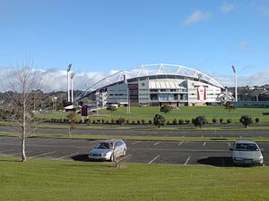
North Harbour Stadium
Sports stadium in Auckland, New Zealand
Distance: Approx. 1100 meters
Latitude and longitude: -36.72694444,174.70166667
North Harbour Stadium is a stadium situated in Albany, in North Shore City, New Zealand. It was opened in 1997, after nearly a decade of discussion, planning and construction. Rugby union, association football, rugby league, and baseball are all played on the main ground.

Pinehurst School
Private co-ed composite, years 1–13 school
Distance: Approx. 938 meters
Latitude and longitude: -36.7402,174.7048
Pinehurst School is a private education institute located in Auckland, New Zealand with a roll of 1136 students in August 2024. The institute was established on 3 March 1991, The school offers the International General Certificate of Secondary Education, IGCSE examination.

Pinehill, New Zealand
Suburb in Auckland, New Zealand
Distance: Approx. 1132 meters
Latitude and longitude: -36.730903,174.723299
Pinehill is a small suburb in the East Coast Bays area of Auckland, New Zealand. The suburb has only recently grown because of the housing estates being built in the area for the rapidly growing Albany area. Pinehill is regularly serviced by buses which go to Takapuna and the Auckland city centre.

Westfield Albany
Shopping mall in Auckland, New Zealand
Distance: Approx. 615 meters
Latitude and longitude: -36.728145,174.708871
Westfield Albany is a shopping centre in the Auckland suburb of Albany, New Zealand, opposite the Albany Lakes Civic Park. It is majority owned (51%) by Scentre Group with the remainder owned by the Singapore Government's GIC. Until 2014 it was wholly owned by Scentre Group, which was formerly part of Westfield Group. Once the last sections opened in April 2008, at 7 ha (70,000 m2) of indoor space (4.9 ha retail [49,000 m2] and 2.1 ha [21,000 m2] offices), and costing around NZ$210 million to construct.

City Impact Church New Zealand
Pentecostal church based in New Zealand
Distance: Approx. 1586 meters
Latitude and longitude: -36.7224,174.7223
City Impact Church (CIC) is a pentecostal church based in Auckland, New Zealand. It operates a network of satellite churches across New Zealand, and in Canada, India, Mexico, the Philippines, and Tonga. It operates several community outreach programmes in New Zealand, including a school, a "Community Impact" support programme, and three childcare centres.

Albany Lakes Civic Park
Public park in Auckland, New Zealand
Distance: Approx. 804 meters
Latitude and longitude: -36.7264,174.7088
Albany Lakes Reserve is a public park located in Albany, New Zealand, a suburb of Auckland. It is adjacent to the Westfield Albany shopping mall, in the centre of the commercial area. The park comprises two artificial lakes that serve both as landscape features and stormwater ponds.

Rosedale, Auckland
Suburb in Auckland, New Zealand
Distance: Approx. 1514 meters
Latitude and longitude: -36.747,174.711
Rosedale is a suburb on the North Shore of Auckland, New Zealand. It is located 12 kilometres north of the city centre, to the south of the suburbs of Pinehill and Albany. It is under the local governance of the Auckland Council.

Upper Harbour Local Board
Local board of Auckland Council in New Zealand
Distance: Approx. 1231 meters
Latitude and longitude: -36.72255,174.70834
The Upper Harbour Local Board is one of the 21 local boards of the Auckland Council, and is one of the two boards overseen by the council's Albany Ward councillors. The board is named for the upper reaches of Auckland's Waitematā Harbour. Its administrative area consists of the suburbs clustered around the upper reaches, and covers much of the north of Auckland's North Shore and part of West Auckland.
Oteha
Suburb in Auckland, New Zealand
Distance: Approx. 1796 meters
Latitude and longitude: -36.718,174.717
Oteha is an Auckland suburb, which is under local governance of Auckland Council. The area is defined by Oteha Valley Road on the north, East Coast Road on the east, Spencer Road on the south, and the Auckland Northern Motorway on the west.
Rosedale Park, New Zealand
Softball stadium in New Zealand
Distance: Approx. 1458 meters
Latitude and longitude: -36.74647222,174.71002778
Rosedale Park, is a reserve and sports ground in the suburb of Rosedale in Auckland, New Zealand. It is the home ground of NRFL Northern Conference side Albany United, North Harbour Softball and North Harbour Hockey. Rosedale park also has a playground, fitness equipment, picnic tables, and a 9-hole frisbee golf course.
Weather in this IP's area
overcast clouds
14 Celsius
14 Celsius
14 Celsius
15 Celsius
1026 hPa
79 %
1026 hPa
1018 hPa
10000 meters
1.79 m/s
4.02 m/s
94 degree
100 %
06:32:56
19:39:24