Country:
 Singapore
Region:
City:
Latitude and Longitude:
Time Zone:
Postal Code:
IP information under different IP Channel
ip-api
Country
Region
City
ASN
Time Zone
ISP
Blacklist
Proxy
Latitude
Longitude
Postal
Route
IPinfo
Country
Region
City
ASN
Time Zone
ISP
Blacklist
Proxy
Latitude
Longitude
Postal
Route
MaxMind
Country
Region
City
ASN
Time Zone
ISP
Blacklist
Proxy
Latitude
Longitude
Postal
Route
Luminati
Country
SGASN
Time Zone
Asia/Singapore
ISP
ICASTCENTER
Latitude
Longitude
Postal
db-ip
Country
Region
City
ASN
Time Zone
ISP
Blacklist
Proxy
Latitude
Longitude
Postal
Route
ipdata
Country
Region
City
ASN
Time Zone
ISP
Blacklist
Proxy
Latitude
Longitude
Postal
Route
Popular places and events near this IP address

Kong Meng San Phor Kark See Monastery
Largest Buddhist temple in Singapore
Distance: Approx. 1163 meters
Latitude and longitude: 1.3614,103.836
The Kong Meng San Phor Kark See Monastery (also the Bright Hill Pujue Chan Monastery) (simplified Chinese: 光明山普觉禅寺; traditional Chinese: 光明山普覺禪寺; pinyin: Guāngmíng Shān Pǔjué Chán Sì; Pe̍h-ōe-jī: Kong-bîng-san-phóo-kak-sī), is a Buddhist temple and monastery in Bishan, Singapore. Built by Zhuan Dao in the early 20th century, to propagate Buddhism and to provide lodging for monks. This monastery is the largest Buddhist temple in Singapore.
Ai Tong School
Government-aided, mixed, sap school
Distance: Approx. 1132 meters
Latitude and longitude: 1.36055556,103.83277778
Ai Tong School (simplified Chinese: 爱同学校; traditional Chinese: 愛同學校; pinyin: Àitóng xuéxiào) is a primary school located in Bishan, Singapore. It is one of the five affiliated primary schools under the Singapore Hokkien Huay Kuan. As a Chinese-medium school, Ai Tong emphasises strongly on the learning of Chinese culture, language and values.

Ang Mo Kio Secondary School
Government school
Distance: Approx. 1370 meters
Latitude and longitude: 1.36780556,103.843
Ang Mo Kio Secondary School (AMKSS) is a co-educational government secondary school in Ang Mo Kio, Singapore, offering education for Secondary 1 to Secondary 5. Students at AMKSS are known as AMKsians.

Mayflower Secondary School
Government school in Ang Mo Kio
Distance: Approx. 516 meters
Latitude and longitude: 1.3686,103.8352
Mayflower Secondary School is a co-educational government secondary school in Ang Mo Kio, Singapore founded in 1981.
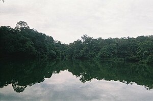
Lower Peirce Reservoir
Reservoir in Singapore
Distance: Approx. 862 meters
Latitude and longitude: 1.36944444,103.82333333
The Lower Peirce Reservoir (Chinese: 贝雅士蓄水池下段 Malay: Takungan Air Lower Peirce) is one of the oldest reservoirs in Singapore. It is located near MacRitchie Reservoir and Upper Peirce Reservoir. Previously known as Kallang River Reservoir or Peirce Reservoir, it was renamed Lower Peirce Reservoir after the creation of Upper Peirce Reservoir.

CHIJ Saint Nicholas Girls' School
Government-aided school in Ang Mo Kio, Singapore
Distance: Approx. 506 meters
Latitude and longitude: 1.3737,103.8343
CHIJ St. Nicholas Girls' School (SNGS) is a government-aided autonomous Catholic girls' school in Ang Mo Kio, Singapore. The school is one of 11 Convent of the Holy Infant Jesus (CHIJ) schools in Singapore and one of the designated Special Assistance Plan (SAP) schools.

Ang Mo Kio Town Garden West
Park in Ang Moh Kio
Distance: Approx. 1447 meters
Latitude and longitude: 1.3743688,103.8434332
Ang Mo Kio Town Garden West is a community park that is situated opposite Ang Mo Kio Public Library, along Ang Mo Kio Avenue 6. The park is popular for recreational activities including jogging and a children's playground, and there is a McDonald's restaurant located at the western side of the park and features a drive-thru facility. The park has been designated with the code 9V-0003 by the international Parks On The Air award program, and so is regularly 'activated' by Amateur Radio operators using portable equipment.
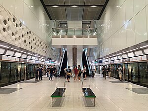
Mayflower MRT station
Mass Rapid Transit station in Singapore
Distance: Approx. 719 meters
Latitude and longitude: 1.3724,103.8372
Mayflower MRT station is an underground Mass Rapid Transit (MRT) station on the Thomson–East Coast Line (TEL) in Ang Mo Kio, Singapore. Situated underneath Ang Mo Kio Avenue 4, the station serves various landmarks including the Kebun Baru Heights Estate, Kebun Baru Community Centre, and CHIJ Saint Nicholas Girls' School. First announced in August 2012 as part of the Thomson Line (TSL), the station was constructed as part of TEL Phase 2 (TEL2) with the merger of the TSL and the Eastern Region Line (ERL).

Bright Hill MRT station
Mass Rapid Transit station in Singapore
Distance: Approx. 857 meters
Latitude and longitude: 1.36384,103.834748
Bright Hill MRT station is an underground Mass Rapid Transit station on the Thomson–East Coast line (TEL). Situated along Sin Ming Avenue in western Bishan, Singapore, it serves various residential estates around the station. It also serves landmarks such as Peirce Secondary School, Ai Tong School, Bishan-Ang Mo Kio Park and the Kong Meng San Phor Kark See Monastery.

Eunoia Junior College
Government school
Distance: Approx. 1262 meters
Latitude and longitude: 1.36304422,103.83948052
Eunoia Junior College (EJC) is a junior college in Singapore which offers Integrated Programme (IP) with Catholic High School, Singapore Chinese Girls' School and CHIJ Saint Nicholas Girls' School. It is located in Bishan, close to Bright Hill MRT station and Bishan MRT station.
Lower Peirce Reservoir Park
Park in Singapore
Distance: Approx. 738 meters
Latitude and longitude: 1.3712,103.8244
Lower Peirce Reservoir Park is a park located along Old Upper Thomson Road in Singapore and overlooks Lower Peirce Reservoir, Singapore's second oldest reservoir. A mature secondary rainforest lines the bank with numerous rubber trees and oil palms. A 900-metre boardwalk constructed in Nov 1998 provides an outdoor classroom for nature study and recreation in a natural forest environment.
259 Ang Mo Kio Avenue 2
Distance: Approx. 224 meters
Latitude and longitude: 1.36863,103.83154
259 Ang Mo Kio Avenue 2 is a building on Ang Mo Kio Avenue 2 in Ang Mo Kio, Singapore. It is the only circular block to have been built by the Housing and Development Board.
Weather in this IP's area
scattered clouds
30 Celsius
35 Celsius
29 Celsius
30 Celsius
1008 hPa
70 %
1008 hPa
1005 hPa
10000 meters
2.57 m/s
150 degree
40 %
06:47:04
18:51:52