103.21.45.219 - IP Lookup: Free IP Address Lookup, Postal Code Lookup, IP Location Lookup, IP ASN, Public IP
Country:
Region:
City:
Location:
Time Zone:
Postal Code:
IP information under different IP Channel
ip-api
Country
Region
City
ASN
Time Zone
ISP
Blacklist
Proxy
Latitude
Longitude
Postal
Route
Luminati
Country
Region
10
City
petalingjaya
ASN
Time Zone
Asia/Kuala_Lumpur
ISP
Symphonet Sdn Bhd
Latitude
Longitude
Postal
IPinfo
Country
Region
City
ASN
Time Zone
ISP
Blacklist
Proxy
Latitude
Longitude
Postal
Route
IP2Location
103.21.45.219Country
Region
negeri sembilan
City
seremban
Time Zone
Asia/Kuala_Lumpur
ISP
Language
User-Agent
Latitude
Longitude
Postal
db-ip
Country
Region
City
ASN
Time Zone
ISP
Blacklist
Proxy
Latitude
Longitude
Postal
Route
ipdata
Country
Region
City
ASN
Time Zone
ISP
Blacklist
Proxy
Latitude
Longitude
Postal
Route
Popular places and events near this IP address
Negeri Sembilan State Mosque
Mosque in Seremban, Negeri Sembilan, Malaysia
Distance: Approx. 958 meters
Latitude and longitude: 2.7222,101.9425
The Negeri Sembilan State Mosque is Negeri Sembilan's state mosque. It is located at Jalan Datuk Hamzah near the lake gardens in Seremban, Malaysia.

Seremban Jamek Mosque
Mosque in Seremban, Negeri Sembilan, Malaysia
Distance: Approx. 136 meters
Latitude and longitude: 2.73080556,101.93830556
The Seremban Jamek Mosque (Malay: Masjid Jamek Seremban) is an old mosque in Seremban, Negeri Sembilan, Malaysia. It is located on the corners of Jalan Yam Tuan and Jalan Dato' Bandar Tunggal. Its architectural style is old Malaccan mosque style.
St. Paul's Institution
All-boys primary and secondary school in Seremban, Negeri Sembilan, Malaysia
Distance: Approx. 617 meters
Latitude and longitude: 2.7289,101.9326
Saint Paul's Institution (Malay: Institusi Saint Paul; abbreviated SPI) is an all-boys (and girls for form 6) and one of the oldest schools in Seremban and also in the country. The school is widely known as SPI and the students of St Paul's Institution are called Paulians. The school is named after Saint Paul.

Seremban railway station
Railway station in Negeri Sembilan, Malaysia
Distance: Approx. 1235 meters
Latitude and longitude: 2.71889,101.941
The Seremban railway station is a Malaysian railway station located in the heart of Seremban, the capital of the state of Negeri Sembilan. The station is named after the city. The station is served by the KTM ETS train services, as well as the KTM Komuter service introduced in 1995.

Seremban District
District in Negeri Sembilan, Malaysia
Distance: Approx. 3292 meters
Latitude and longitude: 2.75,101.91666667
The Seremban District is one of 7 districts in Negeri Sembilan, Malaysia. This is where the capital of Negeri Sembilan, Seremban is located. Seremban District shares a border with Sepang and Hulu Langat Districts, Selangor to the north, Jelebu District to the northeast, Kuala Pilah District to the east, Port Dickson District to the west, and Rembau District to the south.
12th Malaysian Parliament
Distance: Approx. 612 meters
Latitude and longitude: 2.725759,101.942032
The 12th Malaysian Parliament is the last meeting of the legislative branch of the government of Malaysia, the Parliament, comprising the directly elected lower house, the Dewan Rakyat, and the appointed upper house, the Dewan Negara. It met for the first time at the Malaysian Houses of Parliament on 28 April 2008 and met for the last time on 29 November 2012. The King then dissolved the Parliament on 3 April 2013.

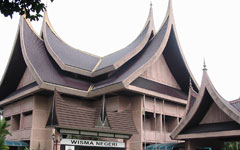
Wisma Negeri, Negeri Sembilan
Government building in Seremban, Negeri Sembilan, Malaysia
Distance: Approx. 602 meters
Latitude and longitude: 2.72614623,101.94226737
Wisma Negeri is Negeri Sembilan's state secretariat building. It was built in 1987 and located at Seremban, Negeri Sembilan, Malaysia. It houses the machineries of the state government, including Menteri Besar's (Chief Minister's) office, Housing and local government unit office and Hall and protocol unit.

Seremban
State capital city and district capital in Negeri Sembilan, Malaysia
Distance: Approx. 912 meters
Latitude and longitude: 2.72222222,101.94166667
Seremban (Negeri Sembilan Malay: Soghomban, Somban; Jawi: سرمبن) is a city in the Seremban District and the capital of the state of Negeri Sembilan in Peninsular Malaysia. The city's administration is run by the Seremban City Council. Seremban gained its city status on 20 January 2020.
Tuanku Ja'afar Royal Gallery
Gallery in Seremban, Negeri Sembilan, Malaysia
Distance: Approx. 1020 meters
Latitude and longitude: 2.72513889,101.94611111
The Tuanku Ja'afar Royal Gallery (Malay: Galeri Diraja Tuanku Ja'afar) is a gallery in Seremban, Negeri Sembilan, Malaysia. The gallery is about the former Negeri Sembilan Yang di-Pertuan Besar Tuanku Ja'afar.

Tuanku Ja'afar Hospital
Hospital in Seremban, Negeri Sembilan, Malaysia
Distance: Approx. 2330 meters
Latitude and longitude: 2.70980556,101.94491667
The Tuanku Ja'afar Hospital (HTJS; Malay: Hospital Tuanku Ja'afar) is a government funded district general hospital in Seremban, Negeri Sembilan, Malaysia. It is the largest hospital in Negeri Sembilan.

Seremban War Memorial
War memorial in Seremban, Malaysia
Distance: Approx. 730 meters
Latitude and longitude: 2.72575,101.94342
The Seremban War Memorial is a cenotaph situated at Jalan Dato Hamzah, Seremban, Negeri Sembilan, Malaysia.

Church of the Visitation (Seremban)
Catholic church in Seremban
Distance: Approx. 562 meters
Latitude and longitude: 2.72545,101.94098
Church of the Visitation, Seremban, is a Roman Catholic Church located in Seremban, Negeri Sembilan, Malaysia.
Weather in this IP's area
light rain
28 Celsius
33 Celsius
28 Celsius
30 Celsius
1013 hPa
91 %
1013 hPa
1006 hPa
10000 meters
1.4 m/s
2.65 m/s
41 degree
100 %

