103.205.245.26 - IP Lookup: Free IP Address Lookup, Postal Code Lookup, IP Location Lookup, IP ASN, Public IP
Country:
Region:
City:
Location:
Time Zone:
Postal Code:
ISP:
ASN:
language:
User-Agent:
Proxy IP:
Blacklist:
IP information under different IP Channel
ip-api
Country
Region
City
ASN
Time Zone
ISP
Blacklist
Proxy
Latitude
Longitude
Postal
Route
db-ip
Country
Region
City
ASN
Time Zone
ISP
Blacklist
Proxy
Latitude
Longitude
Postal
Route
IPinfo
Country
Region
City
ASN
Time Zone
ISP
Blacklist
Proxy
Latitude
Longitude
Postal
Route
IP2Location
103.205.245.26Country
Region
uttarakhand
City
vikasnagar
Time Zone
Asia/Kolkata
ISP
Language
User-Agent
Latitude
Longitude
Postal
ipdata
Country
Region
City
ASN
Time Zone
ISP
Blacklist
Proxy
Latitude
Longitude
Postal
Route
Popular places and events near this IP address

Tons River
River in India
Distance: Approx. 4088 meters
Latitude and longitude: 30.49694444,77.80166667
The Tons (टौंस नदी) is the largest tributary of the Yamuna. It flows through Garhwal region in Uttarakhand, touching Himachal Pradesh. The Tons thrust is named after this river.
Herbertpur
Town in Uttarakhand, India
Distance: Approx. 4774 meters
Latitude and longitude: 30.45,77.73
Herbertpur is a town and a nagar panchayat in Dehradun district Pachhhwadoon in the Indian state of Uttarakhand.
Vikasnagar
City in Uttarakhand, India
Distance: Approx. 102 meters
Latitude and longitude: 30.468,77.774
Vikasnagar is a city and a municipality in Dehradun district in the Indian state of Uttarakhand. Vikas Nagar is also a tehsil in Dehradun district It is also known as Pachawadoon (Western Doon) and is the second financial and economic hub of Dehradun district, after the city of Dehradun. Vikasnagar was earlier known for its tea gardens, exporting tea to other countries.

Dakpathar Barrage
Dam in Dakpathar
Distance: Approx. 4390 meters
Latitude and longitude: 30.50388889,77.79472222
The Dakpathar Barrage is a concrete barrage across the Yamuna River adjacent to Dakpathar in Uttarakhand, India. In a run-of-the-river scheme, the barrage serves to divert water into the East Yamuna Canal for hydroelectric power production at the Dhakrani and Dhalipur Power Plants. The foundation stone for the dam was laid on 23 May 1949 by India's Prime Minister Jawaharlal Nehru.

Dakpathar
Town in Uttarakhand, India
Distance: Approx. 3917 meters
Latitude and longitude: 30.496855,77.798865
Dakpathar, also spelled Dakpatthar and Dak Pather is a small hill town situated in Dehradun district of Uttarakhand, India. It is on the left bank of the Yamuna River and 45 km (28 mi) northwest of the city of Dehradun. Dakpathar lies about 790 meters (2,590 ft) above sea level at the foothills of Shivalik range.
Barotiwala
Distance: Approx. 3267 meters
Latitude and longitude: 30.44055556,77.78611111
Barotiwala is a village in Dharampur Mandal in Solan District in Himachal Pradesh state, India. Barotiwala is located 18.31 km distance from its Mandal Main Town Dharampur. Barotiwala is 25.36 km far from its District Main City, Solan.
Rajpur Daghali
Village in Himachal Pradesh, India
Distance: Approx. 9389 meters
Latitude and longitude: 30.5428,77.7291
Rajpura is a small village in Sirmaur District, Himachal Pradesh, India. It is situated in the hills near Bhagani, at a distance of around 20 km from Paonta Sahib.

Sahaspur Assembly constituency
Constituency of the Uttarakhand legislative assembly in India
Distance: Approx. 9341 meters
Latitude and longitude: 30.39,77.81
Sahaspur Legislative Assembly constituency is one of the seventy electoral Uttarakhand Legislative Assembly constituencies of Uttarakhand state in India. It includes Dehradun Cantonment area. This seat is a part of Tehri Garhwal (Lok Sabha constituency).

Vikasnagar Assembly constituency
Constituency of the Uttarakhand legislative assembly in India
Distance: Approx. 1388 meters
Latitude and longitude: 30.48,77.77
Vikasnagar Legislative Assembly constituency is one of the seventy electoral Uttarakhand Legislative Assembly constituencies of the Indian state of Uttarakhand. It includes the Vikasnagar area of Dehradun District. Vikasnagar is adjacent to Himachal Pradesh district Sirmour and Paonta.

Kanakerha inscription
Distance: Approx. 8939 meters
Latitude and longitude: 30.518,77.8482
The Kanakerha inscription, also spelled Kanakherha inscription, is an inscription found on the side of the hill of Sanchi, dating to the 3rd or 4th century CE. The region of Sanchi-Vidisha was captured from the Satavahanas by the Western Satraps during the rule of Rudrasena II (255-278 CE), as shown by finds of his coinage in the area. The Western Satraps are then known to have remained in the area well into the 4th century, as shown by the Kanakherha inscription, on the hill of Sanchi. The inscription mentions the construction of a well by the Saka (Gupta script: , Śaka) chief and "righteous conqueror" (dharmaviyagi mahadandanayaka) Sridharavarman (Gupta script: , Sridharavarmmana).

Rock edicts of Khalsi
Distance: Approx. 8939 meters
Latitude and longitude: 30.518,77.8482
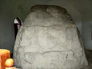
The Rock edicts of Khalsi, also spelled Kalsi, are a group of an Indian rock inscriptions written by the Indian Emperor Ashoka around 250 BCE. They contain some of the most important of the Edicts of Ashoka. The inscription in Khalsi contains all the Major Rock Edicts, from 1 to 14. They were discovered in Khalsi, a village in Uttarakhand, northern India, by Alexander Cunningham about 1850.
Sahaspur, Uttarakhand
Distance: Approx. 9053 meters
Latitude and longitude: 30.3925,77.80916667
Sahaspur is a town situated in the Sahaspur Assembly constituency of Dehradun District in Uttarakhand, India. It is situated 12km away from sub-district headquarter Vikasnagar (tehsildar office) and 23km away from district headquarter Dehradun. As per 2009 stats, Sahaspur is the gram panchayat of Sahaspur village.
Weather in this IP's area
clear sky
14 Celsius
12 Celsius
14 Celsius
14 Celsius
1014 hPa
28 %
1014 hPa
934 hPa
10000 meters
2.7 m/s
2.26 m/s
30 degree
