Country:
 Hong Kong (China)
Region:
City:
Latitude and Longitude:
Time Zone:
Postal Code:
IP information under different IP Channel
ip-api
Country
Region
City
ASN
Time Zone
ISP
Blacklist
Proxy
Latitude
Longitude
Postal
Route
IPinfo
Country
Region
City
ASN
Time Zone
ISP
Blacklist
Proxy
Latitude
Longitude
Postal
Route
MaxMind
Country
Region
City
ASN
Time Zone
ISP
Blacklist
Proxy
Latitude
Longitude
Postal
Route
Luminati
Country
HKASN
Time Zone
Asia/Hong_Kong
ISP
Netsec Limited
Latitude
Longitude
Postal
db-ip
Country
Region
City
ASN
Time Zone
ISP
Blacklist
Proxy
Latitude
Longitude
Postal
Route
ipdata
Country
Region
City
ASN
Time Zone
ISP
Blacklist
Proxy
Latitude
Longitude
Postal
Route
Popular places and events near this IP address

Wong Tai Sin District
District in Hong Kong, China
Distance: Approx. 342 meters
Latitude and longitude: 22.33353,114.19686
Wong Tai Sin District is one of the 18 districts of Hong Kong. It is the only landlocked district in Hong Kong. It is located in Kowloon, and is the northernmost district in Kowloon.
San Po Kong
Industrial and residential area of Hong Kong
Distance: Approx. 189 meters
Latitude and longitude: 22.33547,114.19837
San Po Kong (Chinese: 新蒲崗; Cantonese Yale: sān pòuh gōng) is an area in New Kowloon in Hong Kong. It is largely industrial and partly residential. Administratively, it belongs to Wong Tai Sin District.
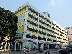
Ho Lap College
Public school in Kowloon, Hong Kong
Distance: Approx. 149 meters
Latitude and longitude: 22.33666667,114.19555556
Ho Lap College (Chinese: 可立中學), HLC, is a band 1 grant-aided co-educational EMI school in San Po Kong, Kowloon, Hong Kong.
Ngau Chi Wan
Distance: Approx. 477 meters
Latitude and longitude: 22.33333333,114.2
Ngau Chi Wan (Chinese: 牛池灣) was a bay beneath Hammer Hill in New Kowloon, Hong Kong. It now refers to an area where Choi Hung Estate is situated.

Nga Tsin Wai Tsuen
Village in Hong Kong
Distance: Approx. 417 meters
Latitude and longitude: 22.335,114.19333333
Nga Tsin Wai Tsuen, also known as Hing Yau Yu Tsuen was a walled village in Wong Tai Sin, Kowloon, Hong Kong with a history spanning more than 600 years. It was the last walled village in the urban core of Hong Kong before its resumption for redevelopment by the Urban Renewal Authority (URA), a government agency, in 2016.

Stone House (Diamond Hill)
Distance: Approx. 466 meters
Latitude and longitude: 22.339577,114.200188
The Stone House is the last structure remaining from the former Tai Hom squatter village. The building is located at No. 4 Tai Koon Yuen (大觀園), Tai Hom, in the Wong Tai Sin District of Kowloon, Hong Kong, China.

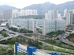
Lower Wong Tai Sin Estate
Public housing estate in Wong Tai Sin, Hong Kong
Distance: Approx. 258 meters
Latitude and longitude: 22.3383,114.1953
Lower Wong Tai Sin Estate (Chinese: 黃大仙下邨) is a public housing estate and Tenants Purchase Scheme estate in Wong Tai Sin, Kowloon, Hong Kong, along the south of Lung Cheung Road, near Wong Tai Sin Temple and MTR Wong Tai Sin station. It is divided into Lower Wong Tai Sin (I) Estate (黃大仙下(一)邨) and Lower Wong Tai Sin (II) Estate (黃大仙下(二)邨). After redevelopment, the estate consists of a total of 24 blocks built between the 1980s and 1990s.

Po Leung Kuk Stanley Ho Sau Nan Primary School
Primary school in Hong Kong
Distance: Approx. 170 meters
Latitude and longitude: 22.3351,114.1967
Po Leung Kuk Stanley Ho Sau Nan Primary School (Chinese: 保良局何壽南小學) is a primary school located in Kai Tak, Kowloon City, in Hong Kong. It is a co-ed primary school using Chinese as the medium of instruction established by the Po Leung Kuk in 1971. There are 24 classes in total, four for each year, and with approximately 40 students in a class, giving approximately 960 students in total.

Ng Wah Catholic Secondary School
Subsidized school
Distance: Approx. 423 meters
Latitude and longitude: 22.333,114.1957
Ng Wah Catholic Secondary School (also referred to as NWC; Chinese: 天主教伍華中學) is a boys' secondary school in San Po Kong, Wong Tai Sin District, Hong Kong. Founded in 1965 by Catholic Diocese of Hong Kong.

Choi Hung Road Playground
Park in Kowloon, Hong Kong
Distance: Approx. 167 meters
Latitude and longitude: 22.338104,114.196975
Choi Hung Road Playground (Chinese: 彩虹道遊樂場) is located in Choi Hung Road, San Po Kong, Wong Tai Sin District, Kowloon, Hong Kong. The playground is managed by the Leisure and Cultural Services Department of Hong Kong.

Mikiki
Shopping mall in San Po Kong, Kowloon
Distance: Approx. 323 meters
Latitude and longitude: 22.3337,114.1968
Mikiki is a shopping centre in San Po Kong, Kowloon, Hong Kong. It is owned by Sun Hung Kai Properties. Mikiki is directly connected to The Latitude, a private housing estate that was also developed by Sun Hung Kai Properties.
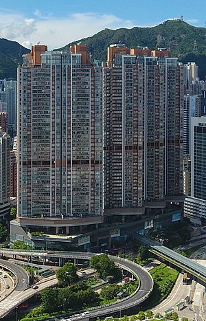
The Latitude
Distance: Approx. 441 meters
Latitude and longitude: 22.3333959,114.1944804
The Latitude (Chinese: 譽.港灣) is a private housing estate in San Po Kong, Hong Kong. It was developed by Sun Hung Kai Properties and was completed in 2010.
Weather in this IP's area
broken clouds
29 Celsius
35 Celsius
27 Celsius
30 Celsius
1002 hPa
83 %
1002 hPa
1000 hPa
10000 meters
2.68 m/s
4.47 m/s
135 degree
52 %
06:11:23
18:22:01