103.201.146.168 - IP Lookup: Free IP Address Lookup, Postal Code Lookup, IP Location Lookup, IP ASN, Public IP
Country:
Region:
City:
Location:
Time Zone:
Postal Code:
IP information under different IP Channel
ip-api
Country
Region
City
ASN
Time Zone
ISP
Blacklist
Proxy
Latitude
Longitude
Postal
Route
Luminati
Country
Region
gj
City
valsad
ASN
Time Zone
Asia/Kolkata
ISP
Quest Consultancy Pvt Ltd
Latitude
Longitude
Postal
IPinfo
Country
Region
City
ASN
Time Zone
ISP
Blacklist
Proxy
Latitude
Longitude
Postal
Route
IP2Location
103.201.146.168Country
Region
gujarat
City
pardi
Time Zone
Asia/Kolkata
ISP
Language
User-Agent
Latitude
Longitude
Postal
db-ip
Country
Region
City
ASN
Time Zone
ISP
Blacklist
Proxy
Latitude
Longitude
Postal
Route
ipdata
Country
Region
City
ASN
Time Zone
ISP
Blacklist
Proxy
Latitude
Longitude
Postal
Route
Popular places and events near this IP address
Paria, Gujarat
Village in Gujarat, India
Distance: Approx. 8268 meters
Latitude and longitude: 20.44444444,72.96833333
Paria is a village situated near Vapi in Valsad district, Gujarat, India. The town of Udwada, 5 kilometers (3.1 mi) away from Paria, has a railway station which connects Paria to the Mumbai-Delhi line of the Western Railways. Paria is under the Jyoti-Gram project of the Gujarat government.

Pardi
Town in Gujarat, India
Distance: Approx. 367 meters
Latitude and longitude: 20.52,72.95
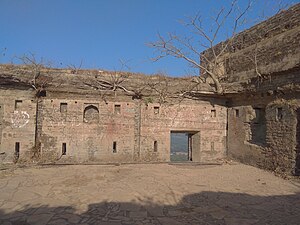
Pardi is a town and a municipality in Valsad district in the Indian state of Gujarat. Historically, there is a Hill in the middle of the town facing the lake where it is said Shivaji built the Killa (Fort). It's from this Killa (Fort) that the town is also called Killa-Pardi.
Abrama
Town in Gujarat, India
Distance: Approx. 7469 meters
Latitude and longitude: 20.58341,72.94231
Abrama is a census town in navsari district in the Indian state of Gujarat.

Atul, Gujarat
Town in Gujarat, India
Distance: Approx. 1634 meters
Latitude and longitude: 20.52882,72.94116
Atul is an industrial village developed by the chemical conglomerate Atul Ltd, located in the Valsad district of Gujarat, India. Although a small village, it has good educational, recreational facilities, banks, temples, post office, police station and a railway station.
Parnera
Town in Gujarat, India
Distance: Approx. 3707 meters
Latitude and longitude: 20.55,72.95
Parnera is a census town in Valsad district in the Indian state of Gujarat.
Udvada
Town in Gujarat, India
Distance: Approx. 8898 meters
Latitude and longitude: 20.4875,72.870556
Udvada is a town situated in Pardi taluka in the Valsad district in the state of Gujarat, India. Udvada is a coastal town located around 24 km from the Valsad city. The Zoroastrian temple, Udvada Atash Behram is situated here.
Pardi Assembly constituency
Legislative Assembly constituency in Gujarat State, India
Distance: Approx. 367 meters
Latitude and longitude: 20.52,72.95
Pardi is one of the 182 Legislative Assembly constituencies of Gujarat state in India. It is part of Valsad district.

Iranshah Atash Behram
Zoroastrian fire temple at Udvada, Gujarat, India
Distance: Approx. 8898 meters
Latitude and longitude: 20.4875,72.87055556
The Iranshah Atash Behram, also known as the Udwada Atash Behram, is a sacred fire housed in a temple in Udvada, Valsad district, Gujarat on the west coast of India. The Atash Bahram, meaning "Victorious Fire", is the oldest fire temple in India, dated to the eighth century, and represents the historical cultural and religious links with Iran. The current temple housing the sacred fire was built in 1742 by Motlibai Wadia from Bombay.
Pardi railway station
Railway station in Gujarat, India
Distance: Approx. 2676 meters
Latitude and longitude: 20.513843,72.924512
Pardi railway station is a small railway station on the Western Railway network in the state of Gujarat, India. Pardi railway station is 11 km away from Valsad railway station. Passenger, MEMU and few Express trains halt at Pardi railway station.
Udvada railway station
Railway station in Gujarat, India
Distance: Approx. 6877 meters
Latitude and longitude: 20.462085,72.919174
Udvada railway station is a railway station on the Western Railway in the state of Gujarat, India. Udvada railway station is 17 km far away from Valsad railway station. Passenger, MEMU and few Express trains halt at Udvada railway station.

Parnera Hill
Distance: Approx. 3651 meters
Latitude and longitude: 20.54944444,72.94805556
Parnera Hill is situated in Parnera town of Valsad district, Gujarat, India. It is located around 6.5 kms away from Valsad city and about 180 kms away from Mumbai. The height of the hill from ground is around 152 metres (499 ft).

Tadkeshwar Mahadev Temple
Hindfu temple in Valsad, Gujarat, India
Distance: Approx. 8277 meters
Latitude and longitude: 20.59,72.93666667
Tadkeshwar Mahadev temple is a Hindu temple. It is located near Abrama town in Valsad district of the Indian state of Gujarat. The temple is on the bank of the Wanki river.
Weather in this IP's area
clear sky
20 Celsius
20 Celsius
20 Celsius
20 Celsius
1012 hPa
59 %
1012 hPa
1010 hPa
10000 meters
2.47 m/s
2.54 m/s
63 degree
8 %