103.201.134.130 - IP Lookup: Free IP Address Lookup, Postal Code Lookup, IP Location Lookup, IP ASN, Public IP
Country:
Region:
City:
Location:
Time Zone:
Postal Code:
IP information under different IP Channel
ip-api
Country
Region
City
ASN
Time Zone
ISP
Blacklist
Proxy
Latitude
Longitude
Postal
Route
Luminati
Country
ASN
Time Zone
Asia/Kolkata
ISP
RailTel Corporation of India Ltd
Latitude
Longitude
Postal
IPinfo
Country
Region
City
ASN
Time Zone
ISP
Blacklist
Proxy
Latitude
Longitude
Postal
Route
IP2Location
103.201.134.130Country
Region
uttarakhand
City
haldwani
Time Zone
Asia/Kolkata
ISP
Language
User-Agent
Latitude
Longitude
Postal
db-ip
Country
Region
City
ASN
Time Zone
ISP
Blacklist
Proxy
Latitude
Longitude
Postal
Route
ipdata
Country
Region
City
ASN
Time Zone
ISP
Blacklist
Proxy
Latitude
Longitude
Postal
Route
Popular places and events near this IP address

Haldwani
Metropolis in Uttarakhand, India
Distance: Approx. 488 meters
Latitude and longitude: 29.22,79.52
Haldwani (Kumaoni: Haldvānī) is the largest city of Kumaon. It is also the second most populous city in the Indian state of Uttarakhand. Haldwani is said to be the financial capital of Uttarakhand, having the most commercial, economic and industrial activities of the state.

Kathgodam
Town in Uttarakhand, India
Distance: Approx. 6338 meters
Latitude and longitude: 29.268,79.545
Kathgodam is a suburb of Haldwani city in the Nainital district of Uttarakhand state of India. It used to be a part of the twin township of Haldwani-Kathgodam, and is immediately north of Haldwani. It is one of the important collection centres for forest products obtained from Kumaon Himalayas.
Kamaluaganja
Neighbourhood in Uttarakhand, India
Distance: Approx. 5018 meters
Latitude and longitude: 29.211676,79.4653716
Kamaluaganja is a residential area located within the municipal limits of Haldwani city in Uttarakhand, India, about 5 km from its city center. It existed as a separate village until December 2017, after which, its administration was handed over to the municipal corporation of Haldwani. It hosts two schools and a vocational training institute.

Nainital–Udhamsingh Nagar Lok Sabha constituency
Lok Sabha Constituency in Uttarakhand
Distance: Approx. 1886 meters
Latitude and longitude: 29.2,79.52
Nainital–Udhamsingh Nagar Lok Sabha constituency is one of the five Lok Sabha (parliamentary) constituencies in Uttarakhand. It comprises two districts namely Nainital (part) and Udham Singh Nagar. This constituency came into existence in 2009, following the delimitation of Lok Sabha constituencies.
Uttarakhand Open University
State Open University in Uttarakhand, Inda
Distance: Approx. 3415 meters
Latitude and longitude: 29.1863,79.512
Uttarakhand Open University (Hindi: उत्तराखण्ड मुक्त विश्वविद्यालय) is a public state open University located in the city of Haldwani in the Indian state of Uttarakhand. The university was established by an Act of Uttarakhand Legislative Assembly on 31 October 2005. UOU is recognized by Distance Education Bureau, University Grants Commission and listed in Association of Indian Universities.

Government Medical College, Haldwani
Medical college in Haldwani, Uttarakhand, India
Distance: Approx. 1211 meters
Latitude and longitude: 29.206622,79.521403
Government Medical College, Haldwani (formerly known as Uttarakhand Forest Hospital Trust Medical College) is a medical college in Haldwani, Uttarakhand, India. It was established in 1997. The college is affiliated with Hemwati Nandan Bahuguna Uttarakhand Medical Education University, Dehradun.

Aryaman Vikram Birla Institute of Learning
Private school in Haldwani, Nainital District, Uttarakhand, India
Distance: Approx. 3594 meters
Latitude and longitude: 29.194,79.4904
Aryaman Vikram Birla Institute of Learning is an English medium co-educational day school located in the city of Haldwani, Uttarakhand. Aryaman Vikram Birla Institute of Learning was established on 30 March 2004 by renowned industrialist Mr. B.K. Birla and Late Mrs.

Haldwani railway station
Indian railway station
Distance: Approx. 1617 meters
Latitude and longitude: 29.2156,79.5333
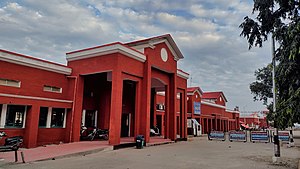
Haldwani railway station is a main railway station located in Haldwani in Nainital district of Uttarakhand State of India. The station code is HDW and is 99 km from the headquarter of the Izzatnagar railway division of North Eastern Railway Zone of Indian Railways. There are three platforms.

Haldwani Assembly constituency
Constituency of the Uttarakhand legislative assembly in India
Distance: Approx. 488 meters
Latitude and longitude: 29.22,79.52
Haldwani Legislative Assembly constituency is one of the seventy electoral Uttarakhand Legislative Assembly constituencies of Uttarakhand state in India. It includes ward no. 1 to 33 of Haldwani Nagar Nigam of Nainital District.

Shemford School Haldwani
Private school in Haldwani, Nainital District, Uttarakhand, India
Distance: Approx. 8905 meters
Latitude and longitude: 29.137605,79.502986
Shemford Senior Secondary School Haldwani is an English medium Co-educational day school located in Haldwani, Uttarakhand. Shemford School was established on 30 March 2016. It is a unit of Shemrock and Shemford Group of Schools and also a unit of Shri Krishnanand J.D. Educational Society.

Indira Gandhi International Sports Stadium
Stadium in Haldwani, Uttarakhand, India
Distance: Approx. 2676 meters
Latitude and longitude: 29.22055556,79.54388889
Indira Gandhi International Sports Stadium is located in Haldwani, Uttarakhand, India. It can seat 25,000 spectators and was inaugurated on 18 December 2016 by Harish Rawat, the then Chief Minister of Uttarakhand. It is spread over 70 acres and has cricket and football grounds, a track for 800-metre race, a hockey field, badminton courts, a lawn tennis court, a boxing ring, and a swimming pool.
Weather in this IP's area
clear sky
12 Celsius
10 Celsius
12 Celsius
12 Celsius
1013 hPa
44 %
1013 hPa
963 hPa
10000 meters
3.19 m/s
5 m/s
272 degree