Country:
Region:
City:
Latitude and Longitude:
Time Zone:
Postal Code:
IP information under different IP Channel
ip-api
Country
Region
City
ASN
Time Zone
ISP
Blacklist
Proxy
Latitude
Longitude
Postal
Route
Luminati
Country
ASN
Time Zone
Asia/Bangkok
ISP
VIETNAM POSTS AND TELECOMMUNICATIONS GROUP
Latitude
Longitude
Postal
IPinfo
Country
Region
City
ASN
Time Zone
ISP
Blacklist
Proxy
Latitude
Longitude
Postal
Route
db-ip
Country
Region
City
ASN
Time Zone
ISP
Blacklist
Proxy
Latitude
Longitude
Postal
Route
ipdata
Country
Region
City
ASN
Time Zone
ISP
Blacklist
Proxy
Latitude
Longitude
Postal
Route
Popular places and events near this IP address

State of Vietnam
1949–1954 constituent state of French Indochina
Distance: Approx. 2033 meters
Latitude and longitude: 10.8,106.65
The State of Vietnam (Vietnamese: Quốc gia Việt Nam; Chữ Hán: 國家越南; French: État du Viêt-Nam) was a governmental entity in Southeast Asia that existed from 1949 until 1955, first as a member of the French Union and later as a country (from 21 July 1954 to 26 October 1955). The state claimed authority over all of Vietnam during the First Indochina War, although large parts of its territory were controlled by the Democratic Republic of Vietnam. The state was created in 1949 by France as part of the French Union and was internationally recognised in 1950.

Tan Son Nhat International Airport
Commercial airport serving Ho Chi Minh City, Vietnam
Distance: Approx. 1871 meters
Latitude and longitude: 10.81888889,106.65194444
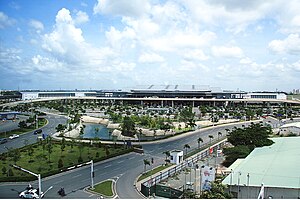
Tân Sơn Nhất International Airport (IATA: SGN, ICAO: VVTS) is an international airport serving Ho Chi Minh City, the most populous city in Vietnam. The airport is located in the Tân Bình district within the Ho Chi Minh City metropolitan area. It is the busiest airport in Vietnam, with 32.5 million passengers in 2016, 38.5 million passengers in 2018, and about 41 million passengers in 2023.

Tân Bình district
Urban district in Ho Chi Minh City, Vietnam
Distance: Approx. 2106 meters
Latitude and longitude: 10.79416667,106.65444444
Tân Bình is an urban district of Ho Chi Minh City, Vietnam. The city's international airport is situated in the district. It consists of 15 wards, from Ward 1 to Ward 15.

Văn Hiến University
University in District 3, Ho Chi Minh City, Vietnam
Distance: Approx. 2169 meters
Latitude and longitude: 10.8037,106.685
Van Hien University is a university located in District 3, Ho Chi Minh City, Vietnam. It is a private university established in 1997. Van Hien University presently has ten faculties: Tourism, Economics and Management, Information Technology, Social Studies and Telecommunication, Technologies and Engineerings, Finance and Accounting (including Department of Laws), Foreign Languages, Oriental Studies, Arts, and Medical and Pharmacy.

Phú Nhuận district
Urban district in Ho Chi Minh City, Vietnam
Distance: Approx. 1518 meters
Latitude and longitude: 10.80166667,106.6775
Phú Nhuận is one of the nineteen urban districts in Ho Chi Minh City, Vietnam. It is densely populated, with 180,100 inhabitants in an area of just 4.88 km2. Phú Nhuận district is sometimes considered the center of Ho Chi Minh City due to its central location from all of the surrounding districts.

Quân khu 7 Stadium
Sports venue in Ho Chi Minh City, Vietnam
Distance: Approx. 860 meters
Latitude and longitude: 10.80166667,106.66722222
Quân khu 7 Stadium (7th Military Region Stadium, Vietnamese: Sân vận động Quân khu 7) is a stadium in Tan Binh District, it's 10 minutes away from Tan Son Nhat International Airport, Ho Chi Minh City. It has a capacity of around 25,000 people.
Vietnam People's Air Force Museum, Ho Chi Minh City
Distance: Approx. 718 meters
Latitude and longitude: 10.805,106.66111111
The Vietnam People's Air Force Museum, Saigon or Bảo Tàng Phòng Không - Không Quân is located on Duong Thang Long (Thang Long Street) in the Phuong 4 District of Ho Chi Minh City. The museum is near to Tan Son Nhat International Airport and adjacent to the gate to Tan Son Nhut Air Base. The museum tells the history of the Vietnam People's Air Force (VPAF) in the Second Indochina War and the Cambodian-Vietnamese War.

Southeastern Armed Forces Museum Military Zone 7
Military museum in Ho Chi Minh City, Vietnam
Distance: Approx. 1035 meters
Latitude and longitude: 10.8,106.666
The Southeastern Armed Forces Museum Military Zone 7 is a military museum located at 247 Hoang Van Thu Street, Tan Binh District, Ho Chi Minh City, Vietnam. It covers all Vietnamese resistance to foreign occupation from the Chinese occupation, the First Indochina War and the Vietnam War and the Cambodian–Vietnamese War. The Museum's opening hours are from 07:30 to 11:30 and from 13:00 to 16:30 daily except Monday.

Tet offensive attack on Joint General Staff Compound
Part of the Vietnam War (1968)
Distance: Approx. 1171 meters
Latitude and longitude: 10.8,106.671
The attack on the Joint General Staff (JGS) Compound, the headquarters of the Republic of Vietnam Military Forces, occurred during the early hours of 31 January 1968. The JGS was located east of Tan Son Nhut Air Base. The attack by Vietcong (VC) forces was one of several major attacks on Saigon in the first days of the Tet offensive.
Military Hospital 175
Hospital in Ho Chi Minh City, Vietnam
Distance: Approx. 1873 meters
Latitude and longitude: 10.81883333,106.68011111
Military Hospital 175 is the central hospital for the south region of the ministry of defense, located in Ho Chi Minh City, Vietnam. It was founded in 1975 by unifying a few military medical divisions and units, most notably K116, K72, and K59, initially to serve veterans and military officers after the Vietnam War. Over the years, it has been slowly opened to the general public and now also acts as a district hospital as well as a trauma center for the civilians.
Ward 1, Phú Nhuận District
Ward in Ho Chi Minh City, Vietnam
Distance: Approx. 2153 meters
Latitude and longitude: 10.79833333,106.68222222
Ward 1 (Phường 1) is a ward of Phú Nhuận District, Ho Chi Minh City, Vietnam.

Hoàng Văn Thụ Park
Park in Ho Chi Minh City
Distance: Approx. 921 meters
Latitude and longitude: 10.8012,106.6643
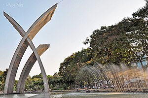
Hoàng Văn Thụ Park (Vietnamese: Công viên Hoàng Văn Thụ) is a park located in Ho Chi Minh City, Vietnam, to the south of Tan Son Nhat International Airport.
Weather in this IP's area
few clouds
32 Celsius
38 Celsius
31 Celsius
32 Celsius
1011 hPa
65 %
1011 hPa
1010 hPa
10000 meters
4.12 m/s
110 degree
20 %
05:48:45
17:27:00