103.200.100.93 - IP Lookup: Free IP Address Lookup, Postal Code Lookup, IP Location Lookup, IP ASN, Public IP
Country:
Region:
City:
Location:
Time Zone:
Postal Code:
ISP:
ASN:
language:
User-Agent:
Proxy IP:
Blacklist:
IP information under different IP Channel
ip-api
Country
Region
City
ASN
Time Zone
ISP
Blacklist
Proxy
Latitude
Longitude
Postal
Route
db-ip
Country
Region
City
ASN
Time Zone
ISP
Blacklist
Proxy
Latitude
Longitude
Postal
Route
IPinfo
Country
Region
City
ASN
Time Zone
ISP
Blacklist
Proxy
Latitude
Longitude
Postal
Route
IP2Location
103.200.100.93Country
Region
maharashtra
City
khopoli
Time Zone
Asia/Kolkata
ISP
Language
User-Agent
Latitude
Longitude
Postal
ipdata
Country
Region
City
ASN
Time Zone
ISP
Blacklist
Proxy
Latitude
Longitude
Postal
Route
Popular places and events near this IP address
Khopoli
Place in Maharashtra, India
Distance: Approx. 1203 meters
Latitude and longitude: 18.789,73.343
Khopoli (Marathi pronunciation: [kʰopoˈliː], ISO: Khōpōlī) is an industrial city in the Khalapur taluka of Raigad district, in the Indian state of Maharashtra, at the base of the Sahyadri mountains. Patalganga River, which is the tailrace channel of the Tata Hydroelectric Power Station, flows through Khopoli. It is a municipal council and is a part of the Mumbai Metropolitan Region.

Rajmachi
Village in Maharashtra
Distance: Approx. 8086 meters
Latitude and longitude: 18.825799,73.3955267
Rajmachi Fort (Killa) is one of the many historical forts in the rugged hills of Sahyadri mountains (Western Ghats). It consists of two twin fortresses Shriwardhan and Manaranjan, with a wide machi (plateau) surrounding the two Balekillas. Udhewadi is a small village of about 60 households (as per 2011 census report) situated on the machi, at the southern foot of Manaranjan Balekilla of Rajmachi Fort.

Maval Lok Sabha constituency
Lok Sabha constituency in Maharashtra
Distance: Approx. 7271 meters
Latitude and longitude: 18.8,73.4
Maval Lok Sabha constituency is one of the 48 Lok Sabha (lower house of the Indian Parliament) constituencies in Maharashtra state in western India. This constituency was created on 19 February 2008 as a part of the implementation of the presidential notification based on the recommendations of the Delimitation Commission of India constituted on 12 July 2002. It first held elections in 2009 and its first Member of Parliament (MP) was Gajanan Babar of Shiv Sena.
Kune Falls
Waterfall in Maharashtra, India
Distance: Approx. 5572 meters
Latitude and longitude: 18.7625,73.38138889
The Kune Falls is a waterfall at Lonavla in Pune district in the Indian state of Maharashtra. It is the 14th highest waterfall in India.

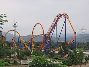
Nitro (Imagicaa)
Floorless coaster at Imagicaa in India
Distance: Approx. 5929 meters
Latitude and longitude: 18.766376,73.279961
Nitro (Hindi: नाइट्रो, romanized: Naitro) is a steel Floorless Coaster at Imagicaa amusement park in Khopoli, Maharashtra, India. Manufactured by Bolliger & Mabillard, the roller coaster reaches a maximum height of 132 feet (40 m) and a maximum speed of 65.2 miles per hour (104.9 km/h). The coaster also features five inversions.

Khandala railway station
Railway Station in Maharashtra, India
Distance: Approx. 5584 meters
Latitude and longitude: 18.7548,73.3769
Khandala station is local station for Khandala town, a twin hill stations of Lonavla – Khandala, in Pune district in state of Maharashtra in India. It is the very next station (towards Pune) to Lonavla from where Pune Suburban Service starts. Khandala Ghat starts after this station towards Mumbai.
Khalapur taluka
Taluka in Maharashtra, India
Distance: Approx. 7349 meters
Latitude and longitude: 18.83,73.284
Khalapur taluka is a subdistrict/upazila/tehsil in Raigad district of Maharashtra. The headquarters of the taluka is Khalapur village. This taluka belongs to the Karjat sub-division, and comprises 130 villages, 5 revenue circles and 25 sajas.
Kune Nane Mawal
Village in Maharashtra
Distance: Approx. 2487 meters
Latitude and longitude: 18.7656767,73.3478053
Kune Nane Mawal is a village in India, situated in Mawal taluka of Pune district in the state of Maharashtra. It encompasses an area of 944 ha (2,333 acres).
Kurvande
Village in Maharashtra
Distance: Approx. 8220 meters
Latitude and longitude: 18.7125479,73.3556052
Kurvande is a village in India, situated in Mawal taluka of Pune district in the state of Maharashtra. It encompasses an area of 2,407 ha (5,948 acres).
Imagicaa
Theme park in Khopoli, India
Distance: Approx. 5971 meters
Latitude and longitude: 18.768,73.279
Imagicaa is a 130-acre (53 ha) theme park in Khopoli, Raigad District, Maharashtra, India. It is owned by Imagicaa World Entertainment Ltd. Imagicaa is listed on the National Stock Exchange (NSE) and the Bombay Stock Exchange (BSE).
Monkey Hill railway station
Railway Station in Maharashtra, India
Distance: Approx. 3488 meters
Latitude and longitude: 18.7832,73.3664
Monkey Hill is a railway station on the Bhor Ghat in Maharashtra, India. It serves as technical halt at which trains stop to check brakes. Almost all trains traveling from Khandala to Palasdari stop at Monkey Hill.
Khalapur Assembly constituency
Constituency of the Maharashtra legislative assembly in India
Distance: Approx. 6917 meters
Latitude and longitude: 18.83,73.29
Khalapur Assembly constituency was one of the 288 assembly constituencies of Maharashtra, a western state of India. Khalapur was also part of Kolaba Lok Sabha constituency. Khalapur seat existed till 2004 elections.
Weather in this IP's area
scattered clouds
29 Celsius
28 Celsius
29 Celsius
29 Celsius
1013 hPa
29 %
1013 hPa
977 hPa
10000 meters
0.98 m/s
1.26 m/s
43 degree
34 %