Country:
 Nauru
NauruRegion:
City:
Latitude and Longitude:
Time Zone:
Postal Code:
IP information under different IP Channel
ip-api
Country
Region
City
ASN
Time Zone
ISP
Blacklist
Proxy
Latitude
Longitude
Postal
Route
IPinfo
Country
Region
City
ASN
Time Zone
ISP
Blacklist
Proxy
Latitude
Longitude
Postal
Route
MaxMind
Country
Region
City
ASN
Time Zone
ISP
Blacklist
Proxy
Latitude
Longitude
Postal
Route
Luminati
Country
NRRegion
08
City
denigomodu
ASN
Time Zone
Pacific/Nauru
ISP
Digicel Nauru Corporation
Latitude
Longitude
Postal
db-ip
Country
Region
City
ASN
Time Zone
ISP
Blacklist
Proxy
Latitude
Longitude
Postal
Route
ipdata
Country
Region
City
ASN
Time Zone
ISP
Blacklist
Proxy
Latitude
Longitude
Postal
Route
Popular places and events near this IP address

Geography of Nauru
Distance: Approx. 1359 meters
Latitude and longitude: -0.53333333,166.91666667
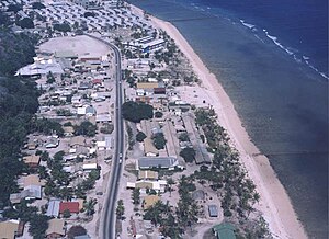
Nauru is a tiny phosphate rock island nation located in the South Pacific Ocean south of the Marshall Islands in Oceania. It is only 53 kilometres (33 mi) south of the Equator at coordinates 0°32′S 166°55′E. Nauru is one of the three great phosphate rock islands in the Pacific Ocean—the others are Banaba (Ocean Island) in Kiribati and Makatea in French Polynesia. Its land area is 21 km2 (8.1 sq mi), and it has a 30-kilometre coastline (19 mi).

Uaboe District
District in Ubenide, Nauru
Distance: Approx. 1197 meters
Latitude and longitude: -0.51666667,166.91666667
Uaboe (also known as Waboe) is a district in the island nation of Nauru, located in the northwest of the island.
Aiwo District
District in Aiwo, Nauru
Distance: Approx. 740 meters
Latitude and longitude: -0.53,166.91166667
Aiwo (rarely Aiue, in earlier times Yangor) is a district in the Pacific country of Nauru. Jarrit Morpak is the city's mayor, elected in 2008. It belongs to Aiwo Constituency.
Denigomodu District
District in Nauru
Distance: Approx. 630 meters
Latitude and longitude: -0.52361111,166.91444444
Denigomodu is a district in the western part of the island of Nauru. It is the most populous district in Nauru. It houses the expatriate housing compound "The Location".
Buada District
District in Buada, Nauru
Distance: Approx. 1359 meters
Latitude and longitude: -0.53333333,166.91666667
Buada is a district in the Pacific nation of Nauru. It is the only district in Buada Constituency. It has a population of 969 (2021).

Linkbelt Oval
Stadium in Nauru
Distance: Approx. 1214 meters
Latitude and longitude: -0.53444444,166.91194444
Linkbelt Oval is a sports stadium on the island nation of Nauru. It is located in Aiwo and was constructed by the Nauru Phosphate Corporation. It is also called the Aida Oval, because Aida, one of the athletic organizations in Nauru, holds its competitions and trainings here.

German attacks on Nauru
German attacks on Nauru in the Second World War
Distance: Approx. 1389 meters
Latitude and longitude: -0.53646667,166.90938333
The German attacks on Nauru refers to the two attacks on Nauru in December 1940. Nauru is an island country in Micronesia, a subregion of Oceania, in the Central Pacific. These attacks were conducted by auxiliary cruisers between 6 and 8 December and on 27 December.
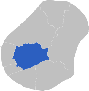
Buada Constituency
Constituency in Nauru
Distance: Approx. 1356 meters
Latitude and longitude: -0.53305556,166.91694444
Buada Constituency is one of the constituencies of Nauru. It returns two members from Buada to the Parliament of Nauru in Yaren. It is the only constituency in the country to be landlocked.
Command Ridge
Highest point in Nauru
Distance: Approx. 1180 meters
Latitude and longitude: -0.53111111,166.91666667
Command Ridge is the highest point of Nauru, with an elevation of 65 metres (213 ft). Passing close to Command Ridge is the boundary between Aiwo and Buada districts.
List of ambassadors of the Republic of China to Nauru
Distance: Approx. 1471 meters
Latitude and longitude: -0.537051,166.910882
The Taiwanese ambassador in the Aiwo District is the official representative of the Government in Taipei to the Government of Nauru. There was a representative of the Government in Beijing to the Government of Nauru between 2002 and 2005.

Nauru International Port
Port in Nauru
Distance: Approx. 594 meters
Latitude and longitude: -0.52904,166.91054
The Nauru International Port is a seaport which is currently under construction on Nauru in the Pacific Ocean. It will become the country's first international seaport and improve commerce and connectivity for the island nation. The $79.59 million USD project will be a climate change-proof port which will be vital in receiving necessary supplies such as fuel, food, and medical supplies.
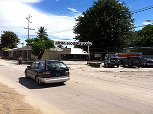
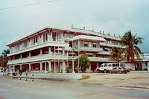
Republic of Nauru Hospital
Hospital in Denigomodu, Nauru
Distance: Approx. 666 meters
Latitude and longitude: -0.52419444,166.91477778
The Republic of Nauru Hospital (RON Hospital) is a rural general hospital in Denigomodu District, Nauru. It is only Public hospital in Denigomodu District, Nauru It was formed by the amalgamation of the government-run Nauru General Hospital and the private Nauru Phosphate Corporation Hospital in 1999. It offers basic medical and surgical care, along with radiological, laboratory, pharmacy and dental services.
Weather in this IP's area
broken clouds
29 Celsius
32 Celsius
29 Celsius
29 Celsius
1009 hPa
70 %
1009 hPa
1009 hPa
10000 meters
4.86 m/s
4.98 m/s
148 degree
54 %
06:47:10
18:53:25