Country:
 Australia
Region:
City:
Latitude and Longitude:
Time Zone:
Postal Code:
IP information under different IP Channel
ip-api
Country
Region
City
ASN
Time Zone
ISP
Blacklist
Proxy
Latitude
Longitude
Postal
Route
IPinfo
Country
Region
City
ASN
Time Zone
ISP
Blacklist
Proxy
Latitude
Longitude
Postal
Route
MaxMind
Country
Region
City
ASN
Time Zone
ISP
Blacklist
Proxy
Latitude
Longitude
Postal
Route
Luminati
Country
AURegion
nsw
City
sydney
ASN
Time Zone
Australia/Sydney
ISP
Over The Wire Pty Ltd
Latitude
Longitude
Postal
db-ip
Country
Region
City
ASN
Time Zone
ISP
Blacklist
Proxy
Latitude
Longitude
Postal
Route
ipdata
Country
Region
City
ASN
Time Zone
ISP
Blacklist
Proxy
Latitude
Longitude
Postal
Route
Popular places and events near this IP address

Parramatta River
River in Australia
Distance: Approx. 513 meters
Latitude and longitude: -33.844654,151.181859
The Parramatta River is an intermediate tide-dominated, drowned valley estuary located in Sydney, New South Wales, Australia. With an average depth of 5.1 metres (17 ft), the Parramatta River is the main tributary of Sydney Harbour, a branch of Port Jackson. Secondary tributaries include the smaller Lane Cove and Duck rivers.
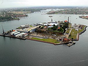
Cockatoo Island
Heritage listed island in Sydney Harbour
Distance: Approx. 800 meters
Latitude and longitude: -33.8475,151.1725
Cockatoo Island Wareamah is a UNESCO World Heritage Site at the confluence of the Parramatta River and Lane Cove River in Sydney Harbour, New South Wales, Australia. Cockatoo Island is the largest of several harbour islands that were once heavily timbered sandstone knolls. Originally the Island rose to 18 m (59 ft) above sea level and was 12.9 hectares (32 acres) but it has been extended to 17.9 ha (44 acres) and is now cleared of most vegetation.

Lane Cove River
River in Sydney, Australia
Distance: Approx. 75 meters
Latitude and longitude: -33.84233328,151.177333
The Lane Cove River, a northern tributary of the Parramatta River, is a tide-dominated, drowned valley estuary west of Sydney Harbour, located in Sydney, New South Wales, Australia. The river winds through a bushland valley and joins Parramatta River at Greenwich and Woolwich, where together they form an arm of Sydney Harbour, and serves as a border along with Middle Harbour separating Sydney's North Shore.

Woolwich, New South Wales
Suburb of Sydney, New South Wales, Australia
Distance: Approx. 639 meters
Latitude and longitude: -33.84,151.171
Woolwich is a suburb on the Lower North Shore of Sydney, in the state of New South Wales, Australia. Woolwich is located 11 kilometres north-west of the Sydney central business district, in the local government area of the Municipality of Hunter's Hill. Woolwich sits on the peninsula between the Lane Cove River and the Parramatta River, jutting out from Hunters Hill.

Woolwich Dock
Distance: Approx. 500 meters
Latitude and longitude: -33.8408,151.1723
Woolwich Dock is a former dry dock and shipyard in Woolwich, Sydney, New South Wales, Australia. The site was purchased by Morts Dock and Engineering Company in 1898. When it was officially opened on 4 December 1901 it was the biggest dry dock in Australia, at 188 metres (617 ft) long and 27 metres (89 ft) wide.
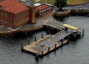
Cockatoo Island ferry wharf
Sydney Ferries ferry wharf
Distance: Approx. 358 meters
Latitude and longitude: -33.83875556,151.17604444
Cockatoo Island ferry wharf is located on Sydney Harbour serving Cockatoo Island.

Woolwich ferry wharf
Sydney Ferries ferry wharf
Distance: Approx. 358 meters
Latitude and longitude: -33.83875556,151.17604444
Woolwich ferry wharf (also known as Valentia Street ferry wharf) is located on Sydney Harbour serving the Sydney suburb of Woolwich. It served by Sydney Ferries Cockatoo Island services operating between Circular Quay and Cockatoo Island. The single wharf is served by First Fleet and Emerald class ferries.
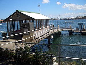
Greenwich Point ferry wharf
Sydney Ferries ferry wharf
Distance: Approx. 292 meters
Latitude and longitude: -33.84204167,151.18072778
Greenwich Point ferry wharf is located on Sydney Harbour serving the Sydney suburb of Greenwich. It served by Sydney Ferries Cockatoo Island services operating between Circular Quay and Cockatoo Island. The single wharf is served by First Fleet and Emerald class ferries.
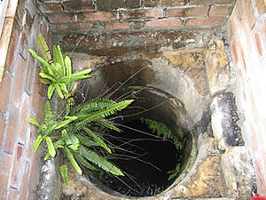
Underground Grain Silos
Historic site in New South Wales, Australia
Distance: Approx. 821 meters
Latitude and longitude: -33.8478,151.1726
The Underground Grain Silos are heritage-listed silos at Cockatoo Island, Sydney Harbour, New South Wales, Australia. It was added to the Australian Commonwealth Heritage List on 22 June 2004.

Biloela House
Historic site in New South Wales, Australia
Distance: Approx. 807 meters
Latitude and longitude: -33.8474,151.1722
Biloela House is a house at the centre of a heritage-listed historic precinct on Cockatoo Island, Sydney Harbour, New South Wales, Australia. It was added to the Australian Commonwealth Heritage List on 22 June 2004.

Cockatoo Island Industrial Conservation Area
Historic site in New South Wales, Australia
Distance: Approx. 839 meters
Latitude and longitude: -33.8477,151.1721
Cockatoo Island Industrial Conservation Area is a heritage-listed protected area relating to the former Cockatoo Island Dockyard at Cockatoo Island, Sydney Harbour, New South Wales, Australia. It was added to the Australian Commonwealth Heritage List on 22 June 2004.

Raywell, Birchgrove
Historic site in New South Wales, Australia
Distance: Approx. 882 meters
Latitude and longitude: -33.8467,151.185
Raywell is a heritage-listed residence at 144 Louisa Road, Birchgrove, Inner West Council, Sydney, New South Wales, Australia. It is also known as Carnegie House. It was added to the New South Wales State Heritage Register on 2 April 1999.
Weather in this IP's area
clear sky
21 Celsius
20 Celsius
20 Celsius
22 Celsius
1009 hPa
33 %
1009 hPa
1009 hPa
10000 meters
7.2 m/s
260 degree
05:47:45
17:49:54