Country:
 Australia
Region:
City:
Latitude and Longitude:
Time Zone:
Postal Code:
IP information under different IP Channel
ip-api
Country
Region
City
ASN
Time Zone
ISP
Blacklist
Proxy
Latitude
Longitude
Postal
Route
IPinfo
Country
Region
City
ASN
Time Zone
ISP
Blacklist
Proxy
Latitude
Longitude
Postal
Route
MaxMind
Country
Region
City
ASN
Time Zone
ISP
Blacklist
Proxy
Latitude
Longitude
Postal
Route
Luminati
Country
AURegion
nsw
City
sydney
ASN
Time Zone
Australia/Sydney
ISP
Over The Wire Pty Ltd
Latitude
Longitude
Postal
db-ip
Country
Region
City
ASN
Time Zone
ISP
Blacklist
Proxy
Latitude
Longitude
Postal
Route
ipdata
Country
Region
City
ASN
Time Zone
ISP
Blacklist
Proxy
Latitude
Longitude
Postal
Route
Popular places and events near this IP address

High Flux Australian Reactor
Australia's first nuclear reactor
Distance: Approx. 2500 meters
Latitude and longitude: -34.05166667,150.98055556
The High Flux Australian Reactor (HIFAR) was Australia's first nuclear research reactor. It was built at the Australian Atomic Energy Commission (AAEC) research establishment at Lucas Heights, Sydney, New South Wales. The reactor was in operation between 1958 and 2007, when it was decommissioned and replaced with the multi-purpose Open-pool Australian lightwater reactor (OPAL), also in Lucas Heights.
Open-pool Australian lightwater reactor
Research nuclear reactor in Australia
Distance: Approx. 2666 meters
Latitude and longitude: -34.051339,150.978799
The Open-pool Australian lightwater reactor (OPAL) is a 20 megawatt (MW) swimming pool nuclear research reactor. Officially opened in April 2007, it replaced the High Flux Australian Reactor as Australia's only nuclear reactor, and is located at the Australian Nuclear Science and Technology Organisation (ANSTO) Research Establishment in Lucas Heights, New South Wales, a suburb of Sydney. Both OPAL and its predecessor have been known simply as the Lucas Heights reactor.
Yarrawarrah
Suburb of Sydney, New South Wales, Australia
Distance: Approx. 2358 meters
Latitude and longitude: -34.0552,151.0321
Yarrawarrah is a suburb in southern Sydney, in the state of New South Wales, Australia 32 kilometres south of the Sydney central business district, in the local government area of the Sutherland Shire. The traditional inhabitants of Yarrawarrah are the Tharawal people, with Yarrawarrah being an Aboriginal word meaning mountain ash. Yarrawarrah is also the name of a ridge which was located in the vicinity between Heathcote and Waterfall.
MOATA
Nuclear reactor in Lucas Heights, Sydney, Australia
Distance: Approx. 2619 meters
Latitude and longitude: -34.05163611,150.97923056
MOATA was a 100 kW thermal Argonaut class reactor built at the Australian Atomic Energy Commission (later ANSTO) Research Establishment at Lucas Heights, Sydney. MOATA went critical at 5:50am on 10 April 1961 and ended operations on 31 May 1995. MOATA was the first reactor to be decommissioned in Australia in 2009.
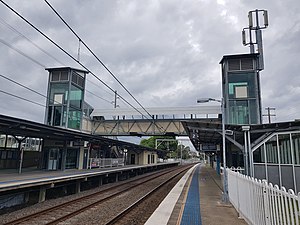
Engadine railway station
Railway station in Sydney, New South Wales, Australia
Distance: Approx. 1340 meters
Latitude and longitude: -34.06763,151.01473
Engadine railway station is located on the Illawarra line, serving the Sydney suburb of Engadine. It is served by Sydney Trains' T4 Eastern Suburbs & Illawarra Line services and limited NSW TrainLink South Coast Line services.
Dunlea Centre
School in Engadine, Sydney, New South Wales, Australia
Distance: Approx. 818 meters
Latitude and longitude: -34.06490278,151.00763889
Dunlea Centre, prior to 2010 known as Boys' Town Engadine, is an Australian residential secondary school for adolescent young people and their families; the centre is focused on working with young people where there are identified behavioural issues. Boys' Town Engadine – Dunlea Centre helps children, young people and their families to overcome the most severe disadvantages – problems such as abuse, homelessness, long term unemployment, mental health issues and the challenges of disability. The school is located in the Sydney suburb of Engadine, New South Wales and is run by the Roman Catholic Salesians, a religious order of priests, in conjunction with specialist teachers and social workers.

Barden Ridge, New South Wales
Suburb of Sydney, New South Wales, Australia
Distance: Approx. 2866 meters
Latitude and longitude: -34.032,151.01
Barden Ridge is a suburb in southern Sydney, in the state of New South Wales, Australia. Barden Ridge is located 29 kilometres south of the Sydney central business district in the local government area of the Sutherland Shire. Barden Ridge is colloquially known to locals as 'The Ridge'.

Engadine, New South Wales
Suburb of Sydney, New South Wales, Australia
Distance: Approx. 1058 meters
Latitude and longitude: -34.06572222,151.01266389
Engadine is a suburb in southern Sydney, in the state of New South Wales, Australia. Engadine is located 33 kilometres (21 mi) south of the Sydney central business district, in the local government area of the Sutherland Shire.

Shire Christian School
School in Australia
Distance: Approx. 2384 meters
Latitude and longitude: -34.036311,151.009526
Shire Christian School is an independent non-denominational Christian co-educational early learning, primary and secondary day school, located in Barden Ridge, a suburb in the Sutherland Shire area of Sydney, New South Wales, Australia. The school was founded as Sutherland Shire Christian School in 1977 by a group of local parents who felt a calling to provide their children with an environment in which to gain an education taught from a Christian perspective. They believed that these features were not to be seen in a public state school; because of this the school upholds a strong Christian ethos that influences most parts of school life.
St John Bosco College, Engadine
School in Australia
Distance: Approx. 2720 meters
Latitude and longitude: -34.08030472,151.01759078
St John Bosco College is an independent systemic Roman Catholic co-educational secondary day school, located in Engadine, a southern suburb of Sydney, New South Wales, Australia. The college was founded in 1978 under the name St John Bosco High School.
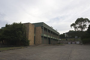
Engadine High School
High school in Engadine, New South Wales, Australia
Distance: Approx. 1224 meters
Latitude and longitude: -34.06194444,151.01888889
Engadine High School (abbreviated as EHS) is a school located in Engadine, Sydney, New South Wales, Australia, on Porter Road. It is a co-educational high school operated by the New South Wales Department of Education, with students from years 7 to 12. The school was established in 1969 as a result of the growing population in the Engadine area.

Lucas Watermills Archaeological Sites
Historic site in Sydney New South Wales, Australia
Distance: Approx. 1327 meters
Latitude and longitude: -34.0457,151.0075
The Lucas Watermills Archaeological Sites are two heritage-listed archaeological sites in Sydney, New South Wales, Australia. The sites comprise the remnants of two convict-era watermills, the Brisbane Mill on the Williams Creek at Creekwood Reserve, Voyager Point and the Woronora Mill on the Woronora River at Barden Ridge. The original watermills were designed by John Lucas and built from 1822 to 1825 by assigned convict labour.
Weather in this IP's area
clear sky
20 Celsius
19 Celsius
19 Celsius
22 Celsius
1009 hPa
33 %
1009 hPa
991 hPa
10000 meters
4.02 m/s
7.6 m/s
108 degree
05:48:27
17:50:34