Country:
 Australia
Region:
City:
Latitude and Longitude:
Time Zone:
Postal Code:
IP information under different IP Channel
ip-api
Country
Region
City
ASN
Time Zone
ISP
Blacklist
Proxy
Latitude
Longitude
Postal
Route
IPinfo
Country
Region
City
ASN
Time Zone
ISP
Blacklist
Proxy
Latitude
Longitude
Postal
Route
MaxMind
Country
Region
City
ASN
Time Zone
ISP
Blacklist
Proxy
Latitude
Longitude
Postal
Route
Luminati
Country
AURegion
nsw
City
sydney
ASN
Time Zone
Australia/Sydney
ISP
Over The Wire Pty Ltd
Latitude
Longitude
Postal
db-ip
Country
Region
City
ASN
Time Zone
ISP
Blacklist
Proxy
Latitude
Longitude
Postal
Route
ipdata
Country
Region
City
ASN
Time Zone
ISP
Blacklist
Proxy
Latitude
Longitude
Postal
Route
Popular places and events near this IP address
Radio VNG
Australian national time signal service
Distance: Approx. 1932 meters
Latitude and longitude: -33.71444444,150.7925
Radio VNG was Australia's national time signal service. It was inaugurated by the Australian Post Office at Lyndhurst, Victoria on 21 September 1964, although a predecessor service using the callsign VLX had begun in March 1946 alongside shortwave radio station VLR. From 1964 until 1987, Radio VNG transmitted on 4.5, 7.5 and 12 MHz from the Lyndhurst transmitters. After 1987 it relocated to Shanes Park, NSW, and transmitted on 2.5, 5, 8.638, 12.984, and 16 MHz.

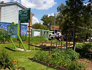
Oakhurst, New South Wales
Suburb of Sydney, New South Wales, Australia
Distance: Approx. 2624 meters
Latitude and longitude: -33.73194444,150.835
Oakhurst is a suburb of Sydney, in the state of New South Wales, Australia 46 kilometres west of the Sydney central business district, in the local government area of the City of Blacktown. It is part of the Greater Western Sydney region.
Bidwill, New South Wales
Suburb of Sydney, New South Wales, Australia
Distance: Approx. 1499 meters
Latitude and longitude: -33.73934,150.81266
Bidwill is a suburb of Sydney, in the state of New South Wales, Australia. Bidwill is located 48 kilometres west of the Sydney central business district, in the local government area of the City of Blacktown and is part of the Greater Western Sydney region.

Blackett, New South Wales
Suburb of Sydney, New South Wales, Australia
Distance: Approx. 1499 meters
Latitude and longitude: -33.73934,150.81266
Blackett is a suburb of Sydney, in the state of New South Wales, Australia. Blackett is located 48 kilometres west of the Sydney central business district, in the local government area of the City of Blacktown and is part of the Greater Western Sydney region.

Dharruk, New South Wales
Suburb of Sydney, New South Wales, Australia
Distance: Approx. 2516 meters
Latitude and longitude: -33.74807,150.8159
Dharruk () is a suburb of Sydney, in the state of New South Wales, Australia. It is located 46 kilometres west of the Sydney central business district, in the local government area of the City of Blacktown and is part of the Greater Western Sydney region. Dharruk is chiefly a residential suburb with almost no industry or commercial activity.
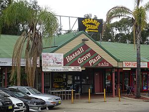
Hassall Grove, New South Wales
Suburb of Sydney, New South Wales, Australia
Distance: Approx. 2511 meters
Latitude and longitude: -33.7333,150.8333
Hassall Grove is a suburb of Sydney, in the state of New South Wales, Australia. Hassall Grove is located 46 kilometres west of the Sydney central business district, in the local government area of the City of Blacktown and is part of the Greater Western Sydney region.
Lethbridge Park, New South Wales
Suburb of Greater Western Sydney, New South Wales, Australia
Distance: Approx. 1414 meters
Latitude and longitude: -33.73333333,150.79444444
Lethbridge Park is a suburb of Greater Western Sydney, in the state of New South Wales, Australia. It is 47 kilometres west of the Sydney central business district, in the local government area of the City of Blacktown and is part of the Greater Western Sydney region.

Shalvey, New South Wales
Suburb of Sydney, New South Wales, Australia
Distance: Approx. 1054 meters
Latitude and longitude: -33.7194,150.8
Shalvey is a suburb of Blacktown, in the state of New South Wales, Australia. Shalvey is located 48 kilometres west of the Sydney central business district, in the local government area of the City of Blacktown and is part of the Greater Western Sydney region.

Willmot, New South Wales
Suburb of Sydney, New South Wales, Australia
Distance: Approx. 1387 meters
Latitude and longitude: -33.72527778,150.7925
Willmot is a suburb of Sydney, in the state of New South Wales, Australia 49 kilometres west of the Sydney central business district, in the local government area of the City of Blacktown and is part of the Greater Western Sydney region.
Cochrane railway station, Sydney
Former railway station in Sydney, Australia
Distance: Approx. 2604 meters
Latitude and longitude: -33.7319,150.78
Cochrane railway station was the second of three stations on the Ropes Creek railway line in Sydney, New South Wales, Australia.
Ropes Crossing, New South Wales
Suburb of Sydney, New South Wales, Australia
Distance: Approx. 1671 meters
Latitude and longitude: -33.73305556,150.79111111
Ropes Crossing is a suburb of Blacktown, Sydney in the state of New South Wales, Australia. Ropes Crossing is located 49 kilometres (30 mi) west of the Sydney central business district, in the local government area of the City of Blacktown and is part of the Greater Western Sydney region.

Ropes Creek railway station
Former railway station in Sydney, Australia
Distance: Approx. 2452 meters
Latitude and longitude: -33.7277,150.78095
Ropes Creek railway station was the terminus station of the Ropes Creek line, serving the then-industrial suburb of Ropes Crossing in Sydney, New South Wales. It was opened on 29 June 1942, after the line was extended past Dunheved to serve the St Marys Munitions factory, and was named after Ropes Creek, a waterway nearby. The station consisted of an island platform, a waiting room, and a footbridge for public access.
Weather in this IP's area
clear sky
21 Celsius
20 Celsius
20 Celsius
23 Celsius
1009 hPa
30 %
1009 hPa
1003 hPa
10000 meters
2.57 m/s
250 degree
05:49:13
17:51:23