Country:
Region:
City:
Latitude and Longitude:
Time Zone:
Postal Code:
IP information under different IP Channel
ip-api
Country
Region
City
ASN
Time Zone
ISP
Blacklist
Proxy
Latitude
Longitude
Postal
Route
Luminati
Country
Region
nsw
City
sydney
ASN
Time Zone
Australia/Sydney
ISP
Over The Wire Pty Ltd
Latitude
Longitude
Postal
IPinfo
Country
Region
City
ASN
Time Zone
ISP
Blacklist
Proxy
Latitude
Longitude
Postal
Route
db-ip
Country
Region
City
ASN
Time Zone
ISP
Blacklist
Proxy
Latitude
Longitude
Postal
Route
ipdata
Country
Region
City
ASN
Time Zone
ISP
Blacklist
Proxy
Latitude
Longitude
Postal
Route
Popular places and events near this IP address

Darlinghurst
Suburb of Sydney, New South Wales, Australia
Distance: Approx. 96 meters
Latitude and longitude: -33.8833,151.225
Darlinghurst is an inner-city suburb in the eastern suburbs of Sydney, New South Wales, Australia. Darlinghurst is located immediately east of the Sydney central business district (CBD) and Hyde Park, within the local government area of the City of Sydney. It is often colloquially referred to as "Darlo".
Paddington, New South Wales
Suburb of Sydney, Australia
Distance: Approx. 248 meters
Latitude and longitude: -33.88477,151.22621
Paddington is an upscale Eastern Suburb of Sydney, in the state of New South Wales, Australia. Located 3 kilometres (1.9 mi) east of the Sydney central business district, Paddington lies across two local government areas. The portion south of Oxford Street lies within the City of Sydney, while the portion north of Oxford Street lies within the Municipality of Woollahra.
Victoria Barracks, Sydney
Army base in Sydney, New South Wales, Australia
Distance: Approx. 433 meters
Latitude and longitude: -33.885905,151.223137
Victoria Barracks is an Australian Army base in Sydney, New South Wales, Australia. Victoria Barracks is located in the suburb of Paddington, between Oxford Street and Moore Park Road. It is just north of the Moore Park, the Sydney Cricket Ground and Sydney Football Stadium.

St Vincent's Hospital, Sydney
Hospital in New South Wales, Australia
Distance: Approx. 526 meters
Latitude and longitude: -33.8797,151.2211
St Vincent's Hospital, Sydney is a leading tertiary referral hospital and research facility located in Darlinghurst, Sydney. Though funded and integrated into the New South Wales state public health system, it is operated by St Vincent's Health Australia. It is affiliated with the University of Tasmania College of Health and Medicine and the University of New South Wales Medical School.
Metro Screen
Distance: Approx. 283 meters
Latitude and longitude: -33.88513889,151.22578889
Metro Screen was a Paddington, Sydney based not-for-profit film, television and digital media training organisation. It was the NSW member of Screen Development Australia (SDA) and was located in the Paddington Town Hall, Cnr Oxford St & Oatley Rd, Paddington. Other members include Open Channel (Vic), QPIX (Qld), Media Resource Centre (SA), Wide Angle Tasmania (Tas), and FTI (WA).
Paddington Reservoir
Public park in Sydney, Australia
Distance: Approx. 326 meters
Latitude and longitude: -33.8853,151.22697
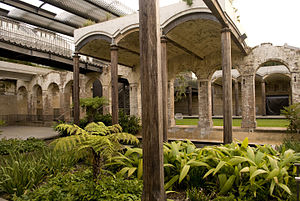
The Paddington Reservoir is a heritage-listed public park located at 255a Oxford Street in the inner eastern Sydney suburb of Paddington. It was designed by Edward Bell and built from 1864 to 1866 and operated as a water reservoir which accepted water from the Botany Swamps pumping station for supply to parts of Sydney between 1866 and 1899. In the twentieth century the site variously functioned as a service station and storage and mechanical workshop site.

Juniper Hall, Paddington
Building in Sydney, Australia
Distance: Approx. 259 meters
Latitude and longitude: -33.8847,151.2268
Juniper Hall, also known as Ormond House, is a heritage-listed former residence and children's home and now retail building and exhibition venue located at 1 Ormond Street, Paddington, Sydney, New South Wales, Australia. It was built from 1824 to 1825 by Robert Cooper. The two-storey Old Colonial Georgian house was added to the New South Wales State Heritage Register on 2 April 1999 and is listed on the (now defunct) Register of the National Estate Juniper Hall was originally the home of Robert Cooper, a gin distiller.
2nd Military District (Australia)
Distance: Approx. 434 meters
Latitude and longitude: -33.8859,151.2231
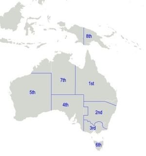
The 2nd Military District was an administrative district of the Australian Army that covered most of New South Wales, with its headquarters in Sydney. The southern border with the 3rd Military District was the Murrumbidgee River rather than the Murray River, and the western part of the state around Broken Hill was part of the 4th Military District. In March 1939 a regional command structure was adopted, with 2nd Military District becoming Eastern Command and the 5th Military District was redesignated Western Command, while the 1st Military District in Queensland became Northern Command, and the three southern districts, the 3rd, 4th and 6th Military Districts in Victoria, South Australia and Tasmania, were amalgamated into Southern Command.
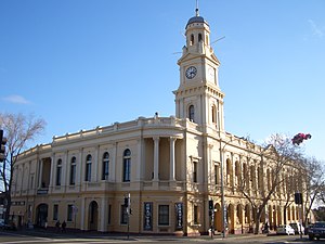
Paddington Town Hall
Town hall in New South Wales, Australia
Distance: Approx. 282 meters
Latitude and longitude: -33.885125,151.225792
The Paddington Town Hall is a heritage-listed former town hall building located at 249 Oxford Street in the inner eastern Sydney suburb of Paddington, in the City of Sydney local government area of New South Wales, Australia. Sir Henry Parkes laid its foundation stone in 1890 when Paddington was a separate municipality. It was designed by John Edward Kemp and built from 1890 to 1891, and remains a distinctive example of Victorian architecture in Sydney.
Paddington Post Office
Post office in Sydney, Australia
Distance: Approx. 251 meters
Latitude and longitude: -33.8847673,151.22636405
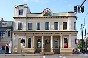
The Paddington Post Office (postcode: 2021) is a heritage-listed post office located at 246 Oxford Street in Paddington, a suburb of Sydney, Australia. The post office is owned and operated by Australia Post. The building was also a former telephone exchange.
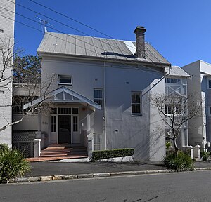
Engehurst
Historic site in New South Wales, Australia
Distance: Approx. 235 meters
Latitude and longitude: -33.8805,151.2258
Engehurst is a heritage-listed residence located in Paddington, New South Wales, Australia. It was designed by John Verge and built from 1834 to 1835. It was added to the New South Wales State Heritage Register on 2 April 1999.

Paddington Substation
Historic site in New South Wales, Australia
Distance: Approx. 190 meters
Latitude and longitude: -33.8843,151.2254
Paddington Substation is a heritage-listed electrical substation built in 1926 and located at 1 Young Street, Paddington in the Municipality of Woollahra local government area of New South Wales, Australia. It is also known as Substation #342 Paddington 33 kV Zone. The property is owned by Ausgrid, an agency of the Government of New South Wales.
Weather in this IP's area
overcast clouds
23 Celsius
24 Celsius
22 Celsius
26 Celsius
1020 hPa
69 %
1020 hPa
1013 hPa
10000 meters
2.24 m/s
10.73 m/s
149 degree
96 %
05:46:57
19:31:10
