103.199.226.170 - IP Lookup: Free IP Address Lookup, Postal Code Lookup, IP Location Lookup, IP ASN, Public IP
Country:
Region:
City:
Location:
Time Zone:
Postal Code:
ISP:
ASN:
language:
User-Agent:
Proxy IP:
Blacklist:
IP information under different IP Channel
ip-api
Country
Region
City
ASN
Time Zone
ISP
Blacklist
Proxy
Latitude
Longitude
Postal
Route
db-ip
Country
Region
City
ASN
Time Zone
ISP
Blacklist
Proxy
Latitude
Longitude
Postal
Route
IPinfo
Country
Region
City
ASN
Time Zone
ISP
Blacklist
Proxy
Latitude
Longitude
Postal
Route
IP2Location
103.199.226.170Country
Region
haryana
City
karnal
Time Zone
Asia/Kolkata
ISP
Language
User-Agent
Latitude
Longitude
Postal
ipdata
Country
Region
City
ASN
Time Zone
ISP
Blacklist
Proxy
Latitude
Longitude
Postal
Route
Popular places and events near this IP address

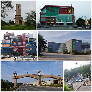
Karnal
City in Haryana, India
Distance: Approx. 628 meters
Latitude and longitude: 29.686,76.989
Karnal () is a city located in the state of Haryana, India and is the administrative headquarters of Karnal District. The city is well connected as it lies on National Highway 01, in the south of the city lies the cities of Panipat and Sonipat and in the north lies Kurukshetra and Yamunanagar city while in the east lies the river Yamuna, on the other end of which lies Saharanpur and Shamli district of Uttar Pradesh on the eastern bank. Karnal was used by the East India Company army as a refuge during the Indian Rebellion of 1857 in Delhi.
Uncha Siwana
Town in Haryana, India
Distance: Approx. 7130 meters
Latitude and longitude: 29.6208,76.9994
Uncha Siwana is a census town in Karnal district in the Indian state of Haryana.
Karnal Aerodrome
Civil Airstrip in Haryana, India used for general operations and pilot training
Distance: Approx. 6267 meters
Latitude and longitude: 29.71416667,77.0375
Karnal Aerodrome is being operated as a pilot training institute owned and operated by the Haryana Institute of Civil Aviation (HICA) under the guidance of the Civil Aviation Department, Government of Haryana. The flying school is spread over an area of 104 acres and is situated about 3 km east of Karnal in the state of Haryana, India. Karnal Flying Club was established in the year 1967 by the Civil Aviation Department of Haryana and is one of the bases of the Haryana Institute of Civil Aviation (HICA).

Karnal Lok Sabha constituency
Lok Sabha constituency in Haryana
Distance: Approx. 2463 meters
Latitude and longitude: 29.7,77
Karnal is one of the 10 Lok Sabha (parliamentary) constituencies in Haryana state in northern India.
National Dairy Research Institute
ICAR-NDRI, a research institute in Haryana, India
Distance: Approx. 2308 meters
Latitude and longitude: 29.704,76.982
National Dairy Research Institute (NDRI) is India's premier institute for dairy research, established in 1955, located in Karnal, Haryana, having been accorded with the status of Deemed University since 1989. NDRI operates under the aegis of Indian Council of Agricultural Research.
Hemda
Village in Haryana, India
Distance: Approx. 7530 meters
Latitude and longitude: 29.681514,76.905466
Hemda is a village in Karnal district of state Haryana, India. It is located on SH-8 between Karnal to Kaithal.
Immaculate Heart Church, Karnal
Church in Haryana , India
Distance: Approx. 3885 meters
Latitude and longitude: 29.709012,77.010464
The Church of Immaculate Heart of Mary usually known as Immaculate Heart Church, Karnal is located in Karnal city of Haryana, India. It stands on Kunjpura Road near National Highway 1 of India besides the well known St. Theresa's Convent School.

Cantonment Church Tower
Church in India
Distance: Approx. 2578 meters
Latitude and longitude: 29.7062,76.9873
The Cantonment Church Tower is a church tower that was formerly part of St. James' Church, a former Anglican church, located in Karnal city of Haryana, India. The 35-metre (115 ft) tower was built as an addition to the former church that was founded in 1806, and is now an historical religious shrine in Karnal.

Karnal railway station
Railway station in Haryana, India
Distance: Approx. 1842 meters
Latitude and longitude: 29.6947,76.9695
Karnal railway station (station code: KUN), at an altitude of 253 metres (830 ft) above mean sea level, is a class "A" station on Delhi–Kalka line, located in Karnal district of Haryana state of India. Built in 1892 by the British Raj, it is one of the oldest stations in India which also holds the title of country's National Heritage Site. It is under Delhi railway division (DRD) of Northern Railway zone (NR) of the Indian Railways (IR).

Karnal Assembly constituency
Constituency of the Haryana legislative assembly in India
Distance: Approx. 988 meters
Latitude and longitude: 29.69,76.99
Karnal Assembly Constituency is a part of Karnal district. It is one of the nine seats which make up Karnal (Lok Sabha constituency).
Pandit Deen Dayal Upadhayaya University of Health Sciences
University teaching hospital in Haryana, India
Distance: Approx. 7854 meters
Latitude and longitude: 29.6185,77.0154
Pandit Deen Dayal Upadhayaya University of Health Sciences, Karnal is a university specialised in health sciences in Karnal, Haryana, India. It was established by Haryana Act No. 27 of 2016 and named University of Health Sciences, Karnal which was changed into Pandit Deen Dayal Upadhayaya University of Health Sciences, Karnal by an amendment act passed in 2018.

Karnal division
Division of Haryana State in India
Distance: Approx. 811 meters
Latitude and longitude: 29.69,76.98
Karnal Division is one of the six divisions of Haryana, a state of India. It comprises the districts of Karnal, Panipat and Kaithal. It was announced in January 2017 and approved by the Haryana cabinet on 2 February 2017.
Weather in this IP's area
clear sky
20 Celsius
18 Celsius
20 Celsius
20 Celsius
1016 hPa
18 %
1016 hPa
987 hPa
10000 meters
3.58 m/s
4.97 m/s
306 degree