Country:
 New Zealand
Region:
City:
Latitude and Longitude:
Time Zone:
Postal Code:
IP information under different IP Channel
ip-api
Country
Region
City
ASN
Time Zone
ISP
Blacklist
Proxy
Latitude
Longitude
Postal
Route
IPinfo
Country
Region
City
ASN
Time Zone
ISP
Blacklist
Proxy
Latitude
Longitude
Postal
Route
MaxMind
Country
Region
City
ASN
Time Zone
ISP
Blacklist
Proxy
Latitude
Longitude
Postal
Route
Luminati
Country
NZRegion
ota
City
wanaka
ASN
Time Zone
Pacific/Auckland
ISP
Two Degrees Networks Limited
Latitude
Longitude
Postal
db-ip
Country
Region
City
ASN
Time Zone
ISP
Blacklist
Proxy
Latitude
Longitude
Postal
Route
ipdata
Country
Region
City
ASN
Time Zone
ISP
Blacklist
Proxy
Latitude
Longitude
Postal
Route
Popular places and events near this IP address

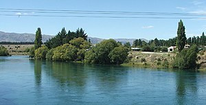
Wānaka
Resort town in Otago, New Zealand
Distance: Approx. 446 meters
Latitude and longitude: -44.7,169.15
Wānaka (Māori pronunciation: [ˈwaːnaka]) is a popular ski and summer resort town in the Otago region of the South Island of New Zealand. At the southern end of Lake Wānaka, it is at the start of the Clutha River and is the gateway to Mount Aspiring National Park. Wānaka is primarily a resort town with both summer and winter seasons.
Albert Town, New Zealand
Town in Otago, New Zealand
Distance: Approx. 3502 meters
Latitude and longitude: -44.683,169.19
Albert Town is located to the east of Wānaka in Otago, New Zealand. Until recently only a farming settlement, the population boom in this area has led to much new development. The confluence of the Clutha and Hāwea Rivers is located here.

Warbirds over Wanaka
Air show in New Zealand
Distance: Approx. 8157 meters
Latitude and longitude: -44.7225,169.24583333
Warbirds over Wanaka is a biennial air show in Wānaka, held on the Easter weekend of even-numbered years since 1988. It is held at Wānaka Airport, 10 km south-east of Wānaka, in the southern South Island of New Zealand. Initially conceived by New Zealand live deer recovery pioneer, Sir Tim Wallis, as a show for him to display his collection of World War II aircraft, the event has grown into a major institution.

Puzzling World
Optical illusion themed tourist attraction in New Zealand
Distance: Approx. 980 meters
Latitude and longitude: -44.697,169.162
Puzzling World is a tourist attraction near Wānaka, New Zealand. It began as a single storey maze in 1973, gradually expanding to become an award-winning complex of optical illusions and puzzling rooms and the world's first 3-D maze. Puzzling World is well known for its Leaning Tower of Wanaka and eccentric lavatory styled as a Roman bathroom.
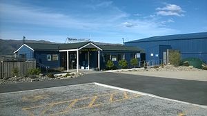
Wānaka Airport
Airport in Otago, New Zealand
Distance: Approx. 8157 meters
Latitude and longitude: -44.7225,169.24583333
Wānaka Airport (IATA: WKA, ICAO: NZWF) is an airport serving the rural town of Wānaka in Otago, New Zealand. The airport currently has scheduled commercial flights from one airline, SoundsAir, with Air New Zealand having ceased flights to the airport in 2013. It largely serves as a base for scenic and charter flights to destinations such as Milford Sound and Mount Aspiring National Park.

Mount Aspiring College
Secondary school in Wānaka, New Zealand
Distance: Approx. 1475 meters
Latitude and longitude: -44.6871,169.1359
Mount Aspiring College is a state coeducational secondary school in Wānaka, New Zealand. It was founded in 1986 after the division of Wānaka Area School into separate primary and secondary schools. The college, though normally a day school, operates a hostel beside the school grounds for 30 Year 13 students.
New Zealand Fighter Pilots Museum
Distance: Approx. 8057 meters
Latitude and longitude: -44.724082,169.243569
The New Zealand Fighter Pilots Museum was an aerospace museum located at Wānaka Airport on New Zealand's South Island. It closed in March 2011 (2011-03) and was replaced in December 2011 by the Warbirds & Wheels museum of military aircraft as well as classic and vintage automobiles and motorcycles. The museum was founded by Sir Tim Wallis and housed in a new building at the Wānaka Airport.

National Transport & Toy Museum
Museum in Wānaka, New Zealand
Distance: Approx. 7738 meters
Latitude and longitude: -44.7227,169.24
The National Transport and Toy Museum in Wānaka, New Zealand is one of the largest private collections in the Southern Hemisphere and displays a large collection of items including over 650 vehicles, 23 aircraft and 100,000 toys plus thousands of miscellaneous items. Owned and operated by one family, the museum is located adjacent to the Wānaka Airport on State Highway 6. The main building houses part of the toy collection, notably a very large collection of Star Wars toys and memorabilia, a display of Barbie dolls through the decades, classic wooden and metal toys, as well as teddy bears and porcelain dolls.
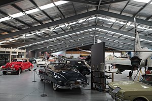
Warbirds and Wheels Museum
Former automotive and aerospace museum in Wānaka, New Zealand
Distance: Approx. 8096 meters
Latitude and longitude: -44.72444444,169.24388889
Warbirds & Wheels in Wānaka, New Zealand was a museum displaying military aircraft and early 20th century classic and vintage automobiles and motorcycles. It opened in 2011 and operated for ten years from premises located at Wānaka Airport on State Highway 6. The museum was opened in December 2011 under an initiative by the Warbirds Over Wanaka Community Trust and three local businessmen to replace the former New Zealand Fighter Pilots Museum.

That Wānaka Tree
Tree in New Zealand
Distance: Approx. 2561 meters
Latitude and longitude: -44.6983,169.1175
That Wānaka Tree, also known as the That Wānaka Willow, is the nickname of a willow tree located at the southern end of Lake Wānaka in the Otago region of New Zealand. The tree grows alone in the water and is a popular destination for tourists to take Instagram photos. As a result of its popularity, it has been damaged on several occasions, both by climbers who broke a few of its limbs and by an instance of vandalism.
Bull Island (New Zealand)
Island in New Zealand
Distance: Approx. 5340 meters
Latitude and longitude: -44.649785,169.131603
Bull Island is an island in Lake Wānaka of Otago, New Zealand.
Weather in this IP's area
clear sky
-4 Celsius
-7 Celsius
-4 Celsius
-4 Celsius
1000 hPa
86 %
1000 hPa
960 hPa
10000 meters
1.92 m/s
2.04 m/s
269 degree
9 %
06:42:23
18:33:44