103.198.113.29 - IP Lookup: Free IP Address Lookup, Postal Code Lookup, IP Location Lookup, IP ASN, Public IP
Country:
 Australia
Region:
City:
Location:
Time Zone:
Postal Code:
ISP:
ASN:
language:
User-Agent:
Proxy IP:
Blacklist:
IP information under different IP Channel
ip-api
Country
Region
City
ASN
Time Zone
ISP
Blacklist
Proxy
Latitude
Longitude
Postal
Route
db-ip
Country
Region
City
ASN
Time Zone
ISP
Blacklist
Proxy
Latitude
Longitude
Postal
Route
IPinfo
Country
Region
City
ASN
Time Zone
ISP
Blacklist
Proxy
Latitude
Longitude
Postal
Route
IP2Location
103.198.113.29Country
auRegion
new south wales
City
clifton grove
Time Zone
Australia/Sydney
ISP
Language
User-Agent
Latitude
Longitude
Postal
ipdata
Country
Region
City
ASN
Time Zone
ISP
Blacklist
Proxy
Latitude
Longitude
Postal
Route
Popular places and events near this IP address

Orange, New South Wales
City in New South Wales, Australia
Distance: Approx. 6110 meters
Latitude and longitude: -33.28333333,149.1
Orange is a city in the Central Tablelands region of New South Wales, Australia. It is 254 km (158 mi) west of the state capital, Sydney [206 km (128 mi) on a great circle], at an altitude of 862 metres (2,828 ft). Orange had an urban population of 41,920 at the 2021 Census, making the city a significant regional centre.

Triple M Central West
Radio station in New South Wales, Australia
Distance: Approx. 6128 meters
Latitude and longitude: -33.283626,149.099984
Triple M Central West (call sign: 2OAG) is an Australian radio station, licensed to Orange, New South Wales. It is owned and operated by Macquarie Regional RadioWorks, and transmits on 105.1 MHz on the FM band. It originally broadcast on 990 kHz, before switching to 1089 kHz, before switching to the FM band.
2EL
Australian radio station
Distance: Approx. 6116 meters
Latitude and longitude: -33.2816,149.0987
2EL is an Australian radio station, owned by Bill Caralis's Broadcast Operations Group. It is licensed to Orange, New South Wales, and transmits on 1089kHz on the AM band. BOG purchased the station from AMI during 2005.

Central West (New South Wales)
Region in New South Wales, Australia
Distance: Approx. 3483 meters
Latitude and longitude: -33.23333333,149.18333333
The Central West is a region in central New South Wales, Australia. The region is situated west of Sydney, which stretches from Lithgow in the east and to as far west as Lake Cargelligo, on the Lachlan River. The Central West is known for its attractions such as the Jenolan Caves, near Oberon and also wineries, as well as rural farmland and natural landscapes.

City of Orange (New South Wales)
Local government area in New South Wales, Australia
Distance: Approx. 6110 meters
Latitude and longitude: -33.28333333,149.1
The City of Orange is a local government area in the Central West region of New South Wales, Australia. Based in Orange, the area is located adjacent to the Mitchell Highway and the Main Western railway line.

Suma Park Dam
Dam in Central West, New South Wales
Distance: Approx. 3611 meters
Latitude and longitude: -33.28166667,149.13444444
Suma Park Dam is a concrete arch dam across the Summer Hill Creek in the central west region of New South Wales, Australia. The main purpose of the dam is to supply potable water to the city of Orange. The impounded reservoir is called Suma Park Reservoir.
Canobolas Rural Technology High School
School in Australia
Distance: Approx. 5194 meters
Latitude and longitude: -33.29166667,149.12194444
The Canobolas Rural Technology High School, also known as Canobolas High School, is a government-funded co-educational comprehensive secondary day school, located in Orange, a rural city located in the Central West region of New South Wales, Australia. Named after Mount Canobolas and founded in 1966, the school enrolled approximately 630 students in 2018, from Year 7 to Year 12, of whom approximately 35 percent identified as Indigenous Australians and five percent were from a language background other than English. The school is operated by the NSW Department of Education.
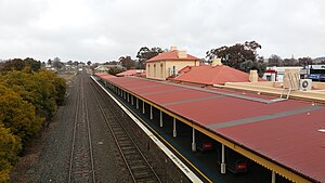
Orange railway station, New South Wales
Railway station in New South Wales, Australia
Distance: Approx. 6046 meters
Latitude and longitude: -33.2868,149.1036
Orange railway station is a heritage-listed former railway bridge and now railway station located on the Main Western line on Paisley Street, Orange in New South Wales, Australia. It was built from 1877 to 1950. It is also known as Orange Railway Station and yard group.

Orange Post Office
Historic commonwealth heritage site in New South Wales, Australia
Distance: Approx. 6141 meters
Latitude and longitude: -33.284,149.1001
The Orange Post Office is a heritage-listed post office located at 221 Summer Street, Orange, City of Orange, New South Wales, Australia. It was designed by Designed by the Colonial Architect’s Office under James Barnet and built by J. Douglas. The property is owned by Australia Post.

Bowen Terrace
Historic site in New South Wales, Australia
Distance: Approx. 5743 meters
Latitude and longitude: -33.2855,149.1065
Bowen Terrace is a heritage-listed series of terrace houses located at 3–25 Bathurst Road, Orange, in the Central West region of New South Wales, Australia. It was designed by John Hale. The property is privately owned.

Union Bank of Australia building, Orange
Historic site in New South Wales, Australia
Distance: Approx. 6252 meters
Latitude and longitude: -33.2814,149.0969
The Union Bank of Australia building is a heritage-listed former school and bank building and now offices and restaurant at 84 Byng Street, Orange, City of Orange, New South Wales, Australia. It is also known as Union Bank of Australia (former), Weymouth House and Hesley Gallery. The property is owned by The Trustee for Union Bank Property Trust (Private).

Uniting Church and Kindergarten Hall, Orange
Church in New South Wales, Australia
Distance: Approx. 6207 meters
Latitude and longitude: -33.2828,149.0984
The Uniting Church and Kindergarten Hall is a heritage-listed church building at 219255 Anson Street, Orange, City of Orange, New South Wales, Australia. It is also known as Wesley Uniting Church. The property is owned by the Uniting Church in Australia.
Weather in this IP's area
clear sky
21 Celsius
21 Celsius
21 Celsius
21 Celsius
1013 hPa
59 %
1013 hPa
918 hPa
10000 meters
3.04 m/s
4.43 m/s
271 degree
1 %