103.197.93.21 - IP Lookup: Free IP Address Lookup, Postal Code Lookup, IP Location Lookup, IP ASN, Public IP
Country:
Region:
City:
Location:
Time Zone:
Postal Code:
ISP:
ASN:
language:
User-Agent:
Proxy IP:
Blacklist:
IP information under different IP Channel
ip-api
Country
Region
City
ASN
Time Zone
ISP
Blacklist
Proxy
Latitude
Longitude
Postal
Route
db-ip
Country
Region
City
ASN
Time Zone
ISP
Blacklist
Proxy
Latitude
Longitude
Postal
Route
IPinfo
Country
Region
City
ASN
Time Zone
ISP
Blacklist
Proxy
Latitude
Longitude
Postal
Route
IP2Location
103.197.93.21Country
Region
jambi
City
jambi
Time Zone
Asia/Jakarta
ISP
Language
User-Agent
Latitude
Longitude
Postal
ipdata
Country
Region
City
ASN
Time Zone
ISP
Blacklist
Proxy
Latitude
Longitude
Postal
Route
Popular places and events near this IP address

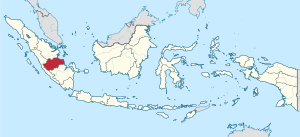
Jambi
Province of Indonesia
Distance: Approx. 1855 meters
Latitude and longitude: -1.58333333,103.61666667
Jambi is a province of Indonesia. It is located on the east coast of central Sumatra and stretches to the Barisan Mountains in the west. Its capital and largest city is also called Jambi.

Jambi (city)
City and capital of Jambi, Indonesia
Distance: Approx. 1340 meters
Latitude and longitude: -1.59,103.61
Jambi is the capital and largest city of the Indonesian province of Jambi. Located on the island of Sumatra, the city is a busy port on the Batang Hari River and an oil- and rubber-producing centre. The city is located 26 km (16 mi) from the ruins of Muaro Jambi Temple Compounds, an important city in the ancient Srivijaya kingdom.

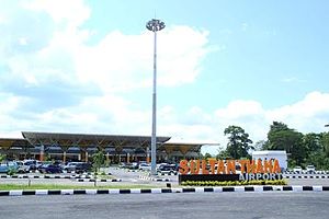
Sultan Thaha Airport
Airport in Jambi, Indonesia
Distance: Approx. 5242 meters
Latitude and longitude: -1.63805556,103.64444444
Sultan Thaha Syaifuddin Airport (Indonesian: Bandar Udara Sultan Thaha Syaifuddin) (IATA: DJB, ICAO: WIJJ) (formerly WIPA), formerly known as Palmerah Airport, is in Jambi City in the Jambi province of Indonesia. It is located in the Paalmerah suburb of Jambi. The airport is named after Thaha Syaifuddin, the last Sultan of Jambi (1816–1904).
Paalmerah
Place in Jambi Province, Indonesia
Distance: Approx. 5244 meters
Latitude and longitude: -1.63333333,103.65
Paalmerah is a town in the Jambi Province of Sumatra, Indonesia. It is located 2.8 miles from the town of Jambi. Nearby towns and villages include Kinati (6.1 nm), Muarakumpe (4.1 nm), Sungaiterap (6.1 nm), Talangpelempang (14.2 nm), Tempino (12.7 nm), Muarabahar (23.0 nm).
Kinati
Place in Jambi Province, Indonesia
Distance: Approx. 7650 meters
Latitude and longitude: -1.61666667,103.55
Kenali Besar is a village in the Jambi Province of Sumatra, Indonesia. It is located 4.1 miles outside the city of Jambi.

Sriwijaya Air Flight 062
2008 aviation accident
Distance: Approx. 4115 meters
Latitude and longitude: -1.63111111,103.63666667
Sriwijaya Air Flight 062 (SJ062/SJY062) was a scheduled domestic passenger flight, operated by Indonesian airline Sriwijaya Air from Soekarno-Hatta International Airport, Jakarta to Sultan Thaha Airport, Jambi. On 27 August 2008, the aircraft operating the flight, a Boeing 737 series 200 registered as PK-CJG, overran the runway and crashed onto a house during its landing attempt at Jambi. Due to the accident, 26 people were injured, including 3 people on the ground.

Ikhsaniyyah Mosque
Mosque in Jambi, Indonesia
Distance: Approx. 2287 meters
Latitude and longitude: -1.5852474,103.6024016
The Ikhsaniyyah Mosque (Indonesian: Masjid Ikhsaniyyah), or better known as Batu Mosque (Stone Mosque), is the oldest mosque in the city of Jambi, Jambi province, Indonesia. The mosque is located on the opposite side of the city center of Jambi, which is divided by the Batanghari River, and specifically in the area of Olak Kemang, Teluk Teluk District.
Weather in this IP's area
overcast clouds
24 Celsius
25 Celsius
24 Celsius
24 Celsius
1009 hPa
96 %
1009 hPa
1006 hPa
10000 meters
1.2 m/s
1.86 m/s
358 degree
97 %