Country:
Region:
City:
Latitude and Longitude:
Time Zone:
Postal Code:
IP information under different IP Channel
ip-api
Country
Region
City
ASN
Time Zone
ISP
Blacklist
Proxy
Latitude
Longitude
Postal
Route
Luminati
Country
ASN
Time Zone
Asia/Kolkata
ISP
Digital Network Associates Pvt Ltd
Latitude
Longitude
Postal
IPinfo
Country
Region
City
ASN
Time Zone
ISP
Blacklist
Proxy
Latitude
Longitude
Postal
Route
db-ip
Country
Region
City
ASN
Time Zone
ISP
Blacklist
Proxy
Latitude
Longitude
Postal
Route
ipdata
Country
Region
City
ASN
Time Zone
ISP
Blacklist
Proxy
Latitude
Longitude
Postal
Route
Popular places and events near this IP address
Vangaon
Village in Maharashtra
Distance: Approx. 7196 meters
Latitude and longitude: 19.86666667,72.75
Vangaon is a village in the Palghar district of Maharashtra, India. It is located in the Dahanu taluka.
Umroli
Village in Maharashtra, India
Distance: Approx. 5359 meters
Latitude and longitude: 19.7558,72.7606
Umroli is a town in Maharashtra. It also has a railway station on the western Line of the Mumbai Suburban Railway. It is located roughly 6 km (3.7 mi) north of Palghar which is the district headquarters.
Katkar
Census town in Maharashtra, India
Distance: Approx. 1568 meters
Latitude and longitude: 19.816,72.7442
Katkar is a census town in Palghar district in the Indian state of Maharashtra.
Pasthal
Census town in Maharashtra, India
Distance: Approx. 2204 meters
Latitude and longitude: 19.8108,72.7277
Pasthal is a census town in Palghar district in the Indian state of Maharashtra.

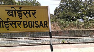
Boisar railway station
Railway Station in Maharashtra, India
Distance: Approx. 1614 meters
Latitude and longitude: 19.7984,72.7615
Boisar railway station is a railway station on the Western line of the Mumbai Suburban Railway network. It is also a terminus for the Boisar - Vasai Road line. The Station is the main mode of transportation for population here.
Boisar
City in Maharashtra, India
Distance: Approx. 999 meters
Latitude and longitude: 19.8036,72.756
Boisar is the largest industrial suburb in the Mumbai Metropolitan Region in the Indian state of Maharashtra. It was originally a part of the Thane district before becoming a part of the Palghar district. It is approximately 111 kilometers (69 miles) away from the state capital Mumbai, and is 98 km (61 mi) from the union territory Daman.
Sai Baba Boulevard
City in Maharashtra, India
Distance: Approx. 426 meters
Latitude and longitude: 19.8,72.75
Sai Baba Town is an eco-friendly township located in Boisar, Maharashtra.

Boisar Assembly constituency
Constituency of the Maharashtra legislative assembly in India
Distance: Approx. 426 meters
Latitude and longitude: 19.8,72.75
Boisar Assembly constituency is one of the 288 Vidhan Sabha (legislative assembly) constituencies of Maharashtra state, western India. This constituency is located in Palghar district. Rajesh Raghunath Patil is the current legislator of this constituency.
Saravali, Dahanu
Village in Maharashtra
Distance: Approx. 2632 meters
Latitude and longitude: 19.7786299,72.7496145
Saravali is a village in the Palghar district of Maharashtra, India. It is located in the Dahanu taluka.
Vire, Dahanu
Village in Maharashtra
Distance: Approx. 7181 meters
Latitude and longitude: 19.8615397,72.773255
Vire is a village in the Palghar district of Maharashtra, India. It is located in the Dahanu taluka.
Kolavali
Village in Maharashtra
Distance: Approx. 7562 meters
Latitude and longitude: 19.8667724,72.724494
Kolavali is a village in the Palghar district of Maharashtra, India. It is located in the Dahanu taluka.
Boisar high-speed railway station
Under-construction high-speed railway station in Maharashtra, India
Distance: Approx. 5031 meters
Latitude and longitude: 19.7904,72.793
Boisar high-speed railway station is an under-construction high-speed railway station on the Mumbai–Ahmedabad high-speed rail corridor. This station is located in Warangade, Boisar, Maharashtra, India. It is the fourth station of the Mumbai–Ahmedabad high-speed rail corridor, after Virar station and before Vapi station.
Weather in this IP's area
clear sky
25 Celsius
26 Celsius
25 Celsius
25 Celsius
1012 hPa
55 %
1012 hPa
1009 hPa
10000 meters
2.96 m/s
3.56 m/s
49 degree
2 %
06:42:44
18:02:34