103.190.138.100 - IP Lookup: Free IP Address Lookup, Postal Code Lookup, IP Location Lookup, IP ASN, Public IP
Country:
 The Philippines
Region:
City:
Location:
Time Zone:
Postal Code:
ISP:
ASN:
language:
User-Agent:
Proxy IP:
Blacklist:
IP information under different IP Channel
ip-api
Country
Region
City
ASN
Time Zone
ISP
Blacklist
Proxy
Latitude
Longitude
Postal
Route
db-ip
Country
Region
City
ASN
Time Zone
ISP
Blacklist
Proxy
Latitude
Longitude
Postal
Route
IPinfo
Country
Region
City
ASN
Time Zone
ISP
Blacklist
Proxy
Latitude
Longitude
Postal
Route
IP2Location
103.190.138.100Country
phRegion
lanao del sur
City
marawi
Time Zone
Asia/Manila
ISP
Language
User-Agent
Latitude
Longitude
Postal
ipdata
Country
Region
City
ASN
Time Zone
ISP
Blacklist
Proxy
Latitude
Longitude
Postal
Route
Popular places and events near this IP address

Lanao del Sur
Province in Bangsamoro, Philippines
Distance: Approx. 1420 meters
Latitude and longitude: 8,124.28
Lanao del Sur (Filipino: Timog Lanao; Meranaw and Iranun: Pagabagatan Ranao; Jawi (Batang Arab): لاناو الجنوبى), officially the Province of Lanao del Sur, is a province in the Philippines located in the Bangsamoro Autonomous Region in Muslim Mindanao (BARMM). The capital is the city of Marawi (the most populous in the province), and it borders Lanao del Norte to the north, Bukidnon to the east, and Maguindanao del Norte and Cotabato to the south. To the southwest lies Illana Bay, an arm of the Moro Gulf.

Marawi
Capital of Lanao del Sur, Philippines
Distance: Approx. 995 meters
Latitude and longitude: 8.0031,124.285
Marawi, officially the Islamic City of Marawi (Maranao: Bandar a Marawi; Filipino: Lungsod ng Marawi; Jawi (Batang Arab): مدينة مراوى الإسلامية), is a component city and capital of the province of Lanao del Sur, Philippines. According to the 2020 census, it has a population of 207,010 people. Marawi is located upon the shores of Lake Lanao.

Roman Catholic Territorial Prelature of Marawi
Latin Catholic ecclesiastical territory in the Philippines
Distance: Approx. 270 meters
Latitude and longitude: 7.99691,124.29456
The Territorial Prelature of Marawi (Latin: Praelatura Territorialis Maraviensis), officially the Prelature of Saint Mary in Marawi, is a Catholic territorial prelature under the Archdiocese of Ozamis in the Philippines. It comprises parishes in the minority Catholic community of Marawi, including at Mindanao State University, and four municipalities in the Lanao Provinces with significant Catholic population: Malabang and Balabagan in Lanao del Sur; and Sultan Naga Dimaporo and Balo-i in Lanao del Norte.

Jamiatu Muslim Mindanao
Private university in Marawi City, Philippines
Distance: Approx. 1684 meters
Latitude and longitude: 8.011536,124.284876
The Jamiatu Muslim Mindanao (JMM) (lit. 'University of Muslim Mindanao') is one of the oldest and biggest Madaris in the Philippines. It was established with the financial backing from the Agama Islam Society in 1956 by the late Sheikh Ahmad Bashir, his devoted companions from the Ulama (Ustad) and Traditional (Cali) Group. Its English Department was founded in 1987 through Board Resolution No.
Sacred Mountain National Park
Protected area in Lanao del Sur, Philippines
Distance: Approx. 2531 meters
Latitude and longitude: 8.02075,124.29797222
Sacred Mountain National Park is a national park in Marawi, Lanao del Sur in the Southern Philippines. The 94-hectare (230-acre) national park and protected area, located in Brgys. Guimba and Papandayan, was established on August 5, 1965, by Republic Act no.
Al Khwarizmi International College
Private college in Marawi City, Philippines
Distance: Approx. 2401 meters
Latitude and longitude: 8.00115,124.271175
RC - Al Khwarizmi International College Foundation, Inc. (AKICFI) is an institution of higher learning in Marawi City, Philippines. It was founded by the Ranao Council.

Siege of Marawi
2017 conflict between the Philippine government and the Maute Group
Distance: Approx. 346 meters
Latitude and longitude: 8,124.29
The siege of Marawi (Filipino: Pagkubkob sa Marawi), also known as the Marawi crisis (Krisis sa Marawi) and the Battle of Marawi (Labanan sa Marawi), was a five-month-long armed conflict in Marawi, Philippines, that started on May 23, 2017, between Philippine government security forces against militants affiliated with the Islamic State (IS), including the Maute and Abu Sayyaf Salafi jihadist groups. The battle also became the longest urban battle in the modern history of the Philippines. According to the Philippine government, the clashes began during an offensive in Marawi to capture Isnilon Hapilon, the leader of the IS-affiliated Abu Sayyaf group, after receiving reports that Hapilon was in the city, possibly to meet with militants of the Maute group.

Amai Pakpak Medical Center
Government hospital in Lanao del Sur, Philippines
Distance: Approx. 1225 meters
Latitude and longitude: 8.00471,124.28356
The Amai Pakpak Medical Center (APMC) is a government hospital in Marawi, Lanao del Sur, Philippines.
Dansalan College
Christian college in Lanao del Sur, Philippines
Distance: Approx. 561 meters
Latitude and longitude: 7.99633,124.29734
Dansalan College is a Protestant-ran college in Marawi, Philippines. The educational institution was founded by missionary, Frank Laubach in 1950. During the Marawi crisis, the college's main building Laubach Hall was reportedly set on fire by Maute group militants on May 23, 2017.
St. Mary's Cathedral (Marawi)
Roman Catholic church in Lanao del Sur, Philippines
Distance: Approx. 261 meters
Latitude and longitude: 7.996998,124.294523
The Cathedral of María Auxiliadora, also known as Saint Mary's Cathedral, is a Roman Catholic church in the predominantly Muslim city of Marawi on the southern island of Mindanao, Philippines. The church is the seat of the Territorial Prelature of Marawi.
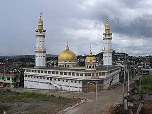
Marawi Grand Mosque
Mosque in Lanao del Sur, Philippines
Distance: Approx. 223 meters
Latitude and longitude: 8.00058,124.29311
The Marawi Grand Mosque, also known as the Islamic Center of Marawi is a mosque located in Pangarungan Village, Marawi City, Lanao del Sur, Philippines.

Dansalan Bato Ali Mosque
Mosque in Lanao del Sur, Philippines
Distance: Approx. 106 meters
Latitude and longitude: 7.99765,124.29287
The Dansalan Bato Ali Mosque (Masjid Dansalan Bato Ali) is a mosque in Marawi City, Lanao del Sur, Philippines.
Weather in this IP's area
overcast clouds
21 Celsius
21 Celsius
21 Celsius
21 Celsius
1014 hPa
94 %
1014 hPa
929 hPa
10000 meters
0.66 m/s
0.98 m/s
30 degree
100 %