Country:
Region:
City:
Latitude and Longitude:
Time Zone:
Postal Code:
IP information under different IP Channel
ip-api
Country
Region
City
ASN
Time Zone
ISP
Blacklist
Proxy
Latitude
Longitude
Postal
Route
IPinfo
Country
Region
City
ASN
Time Zone
ISP
Blacklist
Proxy
Latitude
Longitude
Postal
Route
MaxMind
Country
Region
City
ASN
Time Zone
ISP
Blacklist
Proxy
Latitude
Longitude
Postal
Route
Luminati
Country
ASN
Time Zone
Europe/Berlin
ISP
Securebit AG
Latitude
Longitude
Postal
db-ip
Country
Region
City
ASN
Time Zone
ISP
Blacklist
Proxy
Latitude
Longitude
Postal
Route
ipdata
Country
Region
City
ASN
Time Zone
ISP
Blacklist
Proxy
Latitude
Longitude
Postal
Route
Popular places and events near this IP address

Matheran
Place in Maharashtra, India
Distance: Approx. 6728 meters
Latitude and longitude: 18.9866,73.2679
Matheran is an automobile-free hill station and a municipal council in the Karjat taluka of the Raigad district located in the Indian state of Maharashtra. Matheran is part of the Mumbai Metropolitan Region, and one of the smallest hill stations in India. It is located in the Western Ghats, at an elevation of around 800 m (2,625 feet) above sea level.
Kalundre
Census town in Maharashtra, India
Distance: Approx. 7879 meters
Latitude and longitude: 18.9833,73.1333
Kalundre is a census town in Raigad district in the Indian state of Maharashtra.
Chikhale, Panvel
Village in Maharashtra
Distance: Approx. 5801 meters
Latitude and longitude: 18.977159,73.156736
Chikhale is a village in Panvel Taluk of Raigad district in Maharashtra state in India. It is located at a distance of 6.2 km from its Taluk headquarters Panvel and 33 km distance from Mumbai City. Chikhale has a railway station on the Panvel-Karjat route of the Mumbai Suburban Railway in Navi Mumbai, India with the same name.

Prabalgad
Fort in India
Distance: Approx. 3892 meters
Latitude and longitude: 18.971193,73.225293
Prabalgad (also known as Muranjan, Pradhangad or Prabalmachi) is a fort located between Matheran and Panvel and comes under the Raigad District in the state of Maharashtra, India. The Prabalgad Fort stands at an elevation of 2,300 feet (700 m) in the Western Ghats. The fort was previously known as Muranjan until it was taken over and renamed by the Maratha forces under Chatrapati Shivaji's rule.

Irshalgad
Fortress in India
Distance: Approx. 7988 meters
Latitude and longitude: 18.933568,73.232031
Irshalgad is a fortress located between Matheran and Panvel in Maharashtra, India. It is a sister fort to Prabalgad. The area of the fort is not large but there are several water cisterns cut from the rock.

Kalavantin Durg
Pinnacle in Maharashtra, India
Distance: Approx. 2498 meters
Latitude and longitude: 18.98284,73.219892
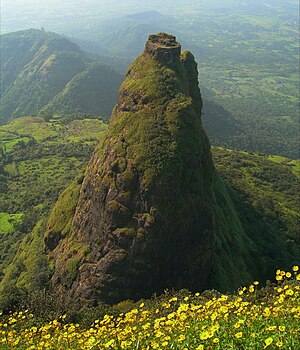
Kalavantin Durg is a 2,250 ft (686 m) high summit located in the Western Ghats, near the Prabalgad fort in the Raigad district of Maharashtra, India. It is also known as Kelve Teen, Kalavantinicha Sulka, or Kalavantin Pinnacle; alternative transliterations include Kalawantin, Kalavati, and Kalavanti. It is a popular trekking destination.

Aman Lodge railway station
Railway station in Raigad district, India
Distance: Approx. 7397 meters
Latitude and longitude: 18.9977,73.276
Aman Lodge railway station is a railway station on the Neral–Matheran railway line of the Matheran Hill Railway. The Aman Lodge – Matheran service continues during monsoon too. As no automobiles are allowed in Matheran, the operation of this shuttle offers an alternative to walking or riding horses from the automobile parking area.
Amity University, Mumbai
Private University in India
Distance: Approx. 9086 meters
Latitude and longitude: 18.9316079,73.1601956
Amity University, Mumbai (AUM) is a private university located in Bhatan Village of Panvel, Maharashtra, India. It was established in 2014 by the Ritnand Balved Education Foundation.
Vichumbe
Village in Maharashtra, India
Distance: Approx. 7460 meters
Latitude and longitude: 18.9873,73.1364
Vichumbe is a village in Panvel Taluka situated in New Panvel, Raigad district in the Indian State of Maharashtra. The village of Vichumbe comes under the Cidco smart city NAINA project.

Matheran railway station
Hill Terminus of Matheran Light Railway
Distance: Approx. 6989 meters
Latitude and longitude: 18.989,73.271
Matheran Railway Station is the upper terminus of the Matheran Hill Railway (MHR). It is the fifth and last station of the narrow gauge line.
Poshir
Village in Maharashtra
Distance: Approx. 5769 meters
Latitude and longitude: 19.0509,73.2202
Poshir is a village near the city of Neral, in the state of Maharashtra, India.
Ajivali
Village in Maharashtra
Distance: Approx. 6988 meters
Latitude and longitude: 18.9558751,73.1595452
Ajivali is a village and gram panchayat in India, situated in Mawal taluka of Pune district in the state of Maharashtra. It encompasses an area of 469 ha (1,159 acres).
Weather in this IP's area
light rain
31 Celsius
37 Celsius
30 Celsius
31 Celsius
1009 hPa
72 %
1009 hPa
1000 hPa
10000 meters
2.04 m/s
2.47 m/s
266 degree
33 %
06:29:16
18:19:49