Country:
Region:
City:
Latitude and Longitude:
Time Zone:
Postal Code:
IP information under different IP Channel
ip-api
Country
Region
City
ASN
Time Zone
ISP
Blacklist
Proxy
Latitude
Longitude
Postal
Route
IPinfo
Country
Region
City
ASN
Time Zone
ISP
Blacklist
Proxy
Latitude
Longitude
Postal
Route
MaxMind
Country
Region
City
ASN
Time Zone
ISP
Blacklist
Proxy
Latitude
Longitude
Postal
Route
Luminati
Country
Region
jt
City
centraljava
ASN
Time Zone
Asia/Jakarta
ISP
PT Berkah Media Kusuma Vision
Latitude
Longitude
Postal
db-ip
Country
Region
City
ASN
Time Zone
ISP
Blacklist
Proxy
Latitude
Longitude
Postal
Route
ipdata
Country
Region
City
ASN
Time Zone
ISP
Blacklist
Proxy
Latitude
Longitude
Postal
Route
Popular places and events near this IP address

Java
Island in Indonesia
Distance: Approx. 821 meters
Latitude and longitude: -7.49166667,110.00444444
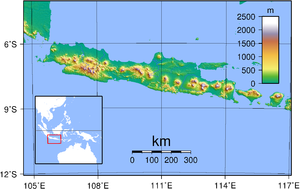
Java is one of the Greater Sunda Islands in Indonesia. It is bordered by the Indian Ocean to the south and the Java Sea to the north. With a population of 156.4 million people, Java is the world's most populous island, home to approximately 56% of the Indonesian population.

Central Java
Province of Indonesia
Distance: Approx. 279 meters
Latitude and longitude: -7.5,110
Central Java (Indonesian: Jawa Tengah, Javanese: ꦗꦮꦶꦩꦢꦾ, romanized: Jawi Tengah) is a province of Indonesia, located in the middle of the island of Java. Its administrative capital is Semarang. It is bordered by West Java in the west, the Indian Ocean and the Special Region of Yogyakarta in the south, East Java in the east, and the Java Sea in the north.

Siege of Batavia
Military campaign in Java by Sultan Agung in 1628 and 1629
Distance: Approx. 823 meters
Latitude and longitude: -7.4916,110.0044
The siege of Batavia was a military campaign led by Sultan Agung of Mataram to capture the Dutch port-settlement of Batavia in Java. The first attempt was launched in 1628, and the second in 1629; both were unsuccessful.

Kabuh Formation
Geologic formation from Central Java
Distance: Approx. 279 meters
Latitude and longitude: -7.5,110
The Kabuh Formation is a Plio-Pleistocene geologic formation from Central Java, consisting of several unnamed members belonging to the Kendeng Group. Many of the fossils discovered from Sambungmacan belonging to this group were discovered in an accumulated sediment deposit in a flood-controlling canal near the Solo River, including a series of hominin crania that are similar in anatomy and geologically younger than the Ngandong hominins upstream. This area was excavated throughout the 1970s.
Weather in this IP's area
moderate rain
24 Celsius
25 Celsius
24 Celsius
24 Celsius
1013 hPa
96 %
1013 hPa
947 hPa
7427 meters
0.63 m/s
1.13 m/s
264 degree
99 %
05:15:41
17:33:33