103.184.93.83 - IP Lookup: Free IP Address Lookup, Postal Code Lookup, IP Location Lookup, IP ASN, Public IP
Country:
Region:
City:
Location:
Time Zone:
Postal Code:
ISP:
ASN:
language:
User-Agent:
Proxy IP:
Blacklist:
IP information under different IP Channel
ip-api
Country
Region
City
ASN
Time Zone
ISP
Blacklist
Proxy
Latitude
Longitude
Postal
Route
db-ip
Country
Region
City
ASN
Time Zone
ISP
Blacklist
Proxy
Latitude
Longitude
Postal
Route
IPinfo
Country
Region
City
ASN
Time Zone
ISP
Blacklist
Proxy
Latitude
Longitude
Postal
Route
IP2Location
103.184.93.83Country
Region
punjab
City
jhelum
Time Zone
Asia/Karachi
ISP
Language
User-Agent
Latitude
Longitude
Postal
ipdata
Country
Region
City
ASN
Time Zone
ISP
Blacklist
Proxy
Latitude
Longitude
Postal
Route
Popular places and events near this IP address

Jhelum District
District of Punjab in Pakistan
Distance: Approx. 648 meters
Latitude and longitude: 32.93333333,73.73333333
Jhelum District (Punjabi: ضلع جہلم) is a district, located partially on the Pothohar Plateau and in Indus Plain, in Punjab, Pakistan. Jhelum is one of the oldest districts of Punjab. It was established on 23 March 1849.

Jhelum
City in Punjab, Pakistan
Distance: Approx. 1049 meters
Latitude and longitude: 32.9425,73.72555556
Jhelum (; جہلم; Punjabi: [d͡ʒéˈlˑɐ̃mᵊ]; Urdu: [d͡ʒeɦˈləm]) is a city on the West Bank of the Jhelum River, which is located in the district of Jhelum in the North of Punjab, Pakistan. It is the 31st largest city of Pakistan by population. Jhelum is known for providing many soldiers to the British Army before independence, and later to the Pakistan armed forces, due to which it is also known as City of Soldiers or Land of Martyrs and Warriors.
St. John's Church, Jhelum
Church in Punjab, Pakistan
Distance: Approx. 1361 meters
Latitude and longitude: 32.92138889,73.72222222
St. John's Church is an Anglican church, now under the Church of Pakistan, located in Jhelum cantonment, Pakistan, beside the river Jhelum.
Zamir Jaffri Cricket Stadium
Cricket stadium in Jhelum, Pakistan
Distance: Approx. 1006 meters
Latitude and longitude: 32.92416667,73.72805556
Zamir Jaffri Cricket Stadium is a cricket stadium in Jhelum, Pakistan. It is named after Jhelum's native poet Syed Zamir Jafri. The stadium is in close proximity to Altaf Park which was built in 1994–95.
St. Thomas' High School, Jhelum
Private primary and secondary school in Arsal Town, Jhelum, Punjab, Pakistan
Distance: Approx. 4112 meters
Latitude and longitude: 32.91583333,73.6875
St. Thomas' High School is a private Catholic primary and secondary school, located in Jhelum, a city in the Jhelum District of the Punjab province of Pakistan.

Jhelum Cantonment
Army cantonment in Punjab, Pakistan
Distance: Approx. 2272 meters
Latitude and longitude: 32.91944444,73.70833333
Jhelum Cantonment (Urdu/Punjabi: جہلم کنٹونمنٹ), commonly abbreviated to Jhelum Cantt (Urdu/Punjabi: جہلم ﮐﻴﻨٹ) is a cantonment adjacent to the city of Jhelum, in Punjab province, Pakistan. It is one of the most important cantonments (army base) in the country, built in 1849 during the British rule of the Indian Subcontinent, and has grown into a strategically important garrison. It is the headquarters of the 23rd Infantry Division of the Pakistan Army, commanded by a Major General.
Raiya Chak Maddu
Pakistani
Distance: Approx. 3959 meters
Latitude and longitude: 32.92666667,73.68472222
Raiya Chak Maddu (pronounced [raːiːja tʃək məd̪u]) is a village in the union council of Monan Jhelum Tehsil. The village is part of the Jhelum District of the Punjab province of Pakistan.
Jhelum Bridge
Bridge on the Jhelum River, Pakistan
Distance: Approx. 1803 meters
Latitude and longitude: 32.9193,73.7365
The Victoria Bridge, also known as Jhelum Bridge (Urdu: جہلم پل ), is situated between Jhelum and Sarai Alamgir on Jhelum River in Pakistan.
Jhelum railway station
Railway station in Pakistan
Distance: Approx. 437 meters
Latitude and longitude: 32.9292,73.7259
Jhelum Railway Station (Urdu and Punjabi: جہلم ریلوے اسٹیشن) is located in Jhelum city, Jhelum district of Punjab province, Pakistan. The station has stoppage of all trains except priority trains like Green Line Express, Rehman Baba Express and Islamabad Express. The famous trains that start, end, or pass through Jhelum station include 1st Eidulfitr Special, 2nd Eid Special, 3rd Eid Special, 4th Eidulfitr Special, Awam Express, Hazara Express and Jaffar Express.

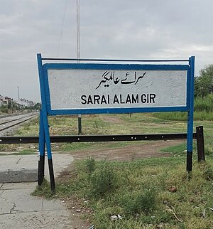
Sarai Alamgir railway station
Railway station in Punjab, Pakistan
Distance: Approx. 3632 meters
Latitude and longitude: 32.9068,73.7494
Sarai Alamgir Railway Station (Urdu and Punjabi: سرائے عالمگیر ریلوے اسٹیشن) is located in Sarai Alamgir, Gujrat district of Punjab province, Pakistan.
Battle of Jhelum (1857)
Part of the Indian Rebellion of 1857
Distance: Approx. 1049 meters
Latitude and longitude: 32.9425,73.72555556
During the Indian Rebellion of 1857 (also known as the Indian Mutiny) a column of troops led by the commander of the 24th Regiment of Foot was sent to disarm Bengal Native Infantry units believed to be at risk of mutiny in Rawalpindi and Jhelum. At Rawalpindi, the 58th Bengal Native Infantry was disarmed peacefully, however the two companies of the 14th Bengal Native Infantry resisted the attempt by force of arms. These two companies were quickly defeated by the British, loyal native troops and the local population.
Baral, Pakistan
Pakistani village
Distance: Approx. 683 meters
Latitude and longitude: 32.92861111,73.73138889
Baral (Urdu, Punjabi: بڑل) is a village on the bank of the Jhelum River, near Pandori in the district of Jhelum in the north of Punjab province, Pakistan. Baral Village is sharing boundary with Mangla Cantonment (also refers as Baral Cantt). It is about 28 km away from Jhelum and 12 km from Dina City.
Weather in this IP's area
clear sky
21 Celsius
19 Celsius
21 Celsius
21 Celsius
1018 hPa
17 %
1018 hPa
988 hPa
10000 meters
0.66 m/s
1.01 m/s
173 degree

