Country:
 India
IndiaRegion:
City:
Latitude and Longitude:
Time Zone:
Postal Code:
IP information under different IP Channel
ip-api
Country
Region
City
ASN
Time Zone
ISP
Blacklist
Proxy
Latitude
Longitude
Postal
Route
IPinfo
Country
Region
City
ASN
Time Zone
ISP
Blacklist
Proxy
Latitude
Longitude
Postal
Route
MaxMind
Country
Region
City
ASN
Time Zone
ISP
Blacklist
Proxy
Latitude
Longitude
Postal
Route
Luminati
Country
INASN
Time Zone
Asia/Kolkata
ISP
Ideastack Solutions Private Limited
Latitude
Longitude
Postal
db-ip
Country
Region
City
ASN
Time Zone
ISP
Blacklist
Proxy
Latitude
Longitude
Postal
Route
ipdata
Country
Region
City
ASN
Time Zone
ISP
Blacklist
Proxy
Latitude
Longitude
Postal
Route
Popular places and events near this IP address

Goregaon
Suburb of Mumbai, Maharashtra, India
Distance: Approx. 1071 meters
Latitude and longitude: 19.155,72.85
Goregaon ([ɡoːɾeɡaːʋ]) is a suburb of Mumbai city, in the Mumbai Suburban district of India. It has a railway station on the Mumbai suburban railway on the Western Line. An extension of the Harbour Line was completed in 2018 due to which it has regular trains to CSMT. This is in addition to existing trains to Churchgate on the Western Line.

Jogeshwari Caves
Caves in Mumbai, India
Distance: Approx. 1336 meters
Latitude and longitude: 19.1391,72.8568
The Jogeshwari Caves are some of the earliest Hinduism cave temple sculptures located in the Mumbai suburb of Jogeshwari, India. The caves date back to the sixth century, Chalukya dynasty. They were found during the excavation of Ajanta and Elephanta.
Mumbai North West Lok Sabha constituency
Constituency of the Indian parliament in Maharashtra
Distance: Approx. 1579 meters
Latitude and longitude: 19.14,72.86
Mumbai North West Lok Sabha constituency is a constituency represented in the Lok Sabha of the Parliament of India, having approximately 1.6 million voters.
Amboli, Mumbai
Neighbourhood in Mumbai Suburban, Maharashtra, India
Distance: Approx. 1886 meters
Latitude and longitude: 19.1293,72.8434
Amboli is in Andheri (West), Mumbai, Maharashtra. Earlier known as Ambolim, it is situated very close to Andheri railway station and Jogeshwari railway station. At its heart, it also has a playground known as Joe and Helen Ground.
St. Blaise High School
Government school, catholic, co-ed school in Mumbai, Maharashtra, India
Distance: Approx. 2090 meters
Latitude and longitude: 19.12722222,72.84638889
St. Blaise is a school founded in 1879 and is run by the Roman Catholic parish of St. Blaise, Amboli in the Indian state of Maharashtra.
Ismail Yusuf College
College of Mumbai, India
Distance: Approx. 1621 meters
Latitude and longitude: 19.13334,72.854022
Ismail Yusuf College, is the fourth oldest college of Mumbai, India. "I Y college", as it is popularly known, is managed by Government of Maharashtra. It is the oldest college in North Mumbai.
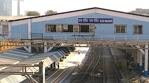
Ram Mandir railway station
Station on Mumbai Suburban Railway
Distance: Approx. 682 meters
Latitude and longitude: 19.151006,72.850144
Ram Mandir railway station (station code: RMAR) is a railway station on the Western and Harbour lines of the Mumbai Suburban Railway, serving the Oshiwara locality. The station is located in between Jogeshwari railway station and Goregaon railway station and is named after the century-old temple of Lord Ram in its vicinity. The station was opened to commuters on 22 December 2016.

Jogeshwari East Assembly constituency
Constituency of the Maharashtra legislative assembly in India
Distance: Approx. 1587 meters
Latitude and longitude: 19.135,72.856
Jogeshwari East Assembly constituency is one of the 26 Vidhan Sabha constituencies located in the Mumbai Suburban district.

Andheri West Assembly constituency
Constituency of the Maharashtra legislative assembly in India
Distance: Approx. 1904 meters
Latitude and longitude: 19.13,72.84
Andheri West constituency is one of the 26 Vidhan Sabha constituencies located in the Mumbai Suburban district.
Indian Film & Television Directors' Association
Trade union in India
Distance: Approx. 1385 meters
Latitude and longitude: 19.140407,72.834634
The Indian Film & Television Directors' Association (IFTDA) is an entertainment guild that represents the interests of film and television directors in India. It was founded as the Indian Film Directors' Association (IFDA) in 1960, before adopting today's name in 2007 and welcoming television directors into the guild. Ashoke Pandit is the current president, a role that has been held in the past by K.A. Abbas, Madhusudan, Basu Bhattacharya, Ramesh Saigal, Mahesh Kaul, and Mohan Segal.

Goregaon East metro station
Mumbai Metro's Red Line 7 metro station
Distance: Approx. 1301 meters
Latitude and longitude: 19.15272,72.85652
Goregaon (East) is an elevated metro station on the North-South corridor of the Red Line 7 of Mumbai Metro in Mumbai, India. This metro station was inaugurated on 20 January 2023 by Prime Minister Narendra Modi.

Jogeshwari East metro station
Mumbai Metro's Red Line 7 metro station
Distance: Approx. 973 meters
Latitude and longitude: 19.14302,72.8551
Jogeshwari (East) is an elevated metro station on the North-South corridor of the Red Line 7 of Mumbai Metro in Mumbai, India. This metro station was inaugurated on 20 January 2023 by Prime Minister Narendra Modi.
Weather in this IP's area
haze
31 Celsius
37 Celsius
31 Celsius
31 Celsius
1009 hPa
70 %
1009 hPa
1008 hPa
5000 meters
3.6 m/s
210 degree
40 %
06:33:56
18:12:51