103.181.23.12 - IP Lookup: Free IP Address Lookup, Postal Code Lookup, IP Location Lookup, IP ASN, Public IP
Country:
 India
IndiaRegion:
City:
Location:
Time Zone:
Postal Code:
ISP:
ASN:
language:
User-Agent:
Proxy IP:
Blacklist:
IP information under different IP Channel
ip-api
Country
Region
City
ASN
Time Zone
ISP
Blacklist
Proxy
Latitude
Longitude
Postal
Route
db-ip
Country
Region
City
ASN
Time Zone
ISP
Blacklist
Proxy
Latitude
Longitude
Postal
Route
IPinfo
Country
Region
City
ASN
Time Zone
ISP
Blacklist
Proxy
Latitude
Longitude
Postal
Route
IP2Location
103.181.23.12Country
inRegion
maharashtra
City
malegaon
Time Zone
Asia/Kolkata
ISP
Language
User-Agent
Latitude
Longitude
Postal
ipdata
Country
Region
City
ASN
Time Zone
ISP
Blacklist
Proxy
Latitude
Longitude
Postal
Route
Popular places and events near this IP address
Malegaon
City in Maharashtra, India
Distance: Approx. 1741 meters
Latitude and longitude: 20.55,74.55
Malegaon (IAST: Mālegāv; Pronunciation: [malegaːʋ]) is a city in Nashik District of Maharashtra State in India. It is situated on the bank of the Girna river with Mosam River river flowing through middle of the city dividing it in two parts. Malegaon is famous for its loom industries.

Dyane
Census town in Maharashtra, India
Distance: Approx. 3990 meters
Latitude and longitude: 20.5783,74.5098
Dyane is a census town in Nashik district in the state of Maharashtra, India.
Soyagaon
Town and Taluka in Maharashtra, India
Distance: Approx. 2723 meters
Latitude and longitude: 20.551389,74.507222
Soyagaon or soegaon is a Town and Taluka in Nashik District in the Indian state of Maharashtra.
Malegaon Lok Sabha constituency
Former constituency of the Indian parliament in Maharashtra
Distance: Approx. 6559 meters
Latitude and longitude: 20.6,74.5
Malegaon Lok Sabha constituency was one of the 48 Lok Sabha (parliamentary) constituencies of Maharashtra state in western India.
Dabhadi, Malegaon
Town in Maharashtra, India
Distance: Approx. 6733 meters
Latitude and longitude: 20.5567775,74.4691086
Dabhadi is a small town in Malegaon taluka of Nashik district in the Indian state of Maharashtra. It is located on Maharashtra State Highway 19 between the towns of Malegaon and Satana. Before the delimitation of Vidhan Sabha constituencies in 2008, Dabhadi was the constituency number 74 of Maharashtra Legislative Assembly between 1977 and 2004.

Malegaon Central Assembly constituency
Constituency of the Maharashtra legislative assembly in India
Distance: Approx. 1476 meters
Latitude and longitude: 20.56,74.524
Malegaon Central Assembly constituency is one of the 288 Vidhan Sabha (legislative assembly) constituencies in Maharashtra state in western India. It is part of Dhule Lok Sabha constituency.

Malegaon Outer Assembly constituency
Constituency of the Maharashtra legislative assembly in India
Distance: Approx. 4124 meters
Latitude and longitude: 20.53,74.5
Malegaon Outer Assembly constituency is one of the 288 Vidhan Sabha (legislative assembly) constituencies of Maharashtra state in western India. Before the delimitation of Vidhan Sabha constituencies in 2008, Dabhadi (74) was a constituency of the Maharashtra Legislative Assembly between 1977-2004. The Malegaon Outer (115) constituency belongs to Dhule parliamentary constituency.
Mausam River
Distance: Approx. 2134 meters
Latitude and longitude: 20.53083333,74.53277778
The Mausam River (Mosam River, Mokshaganga River) is a river in Nashik District in Maharashtra, India. It is a left tributary of the Girna River.
Kashti, Nashik
Village in Maharashtra
Distance: Approx. 9594 meters
Latitude and longitude: 20.62222222,74.48305556
Kashti is a panchayat village in the state of Maharashtra, India. Administratively, Kashti is under Malegaon Taluka of Nashik District in Maharashtra. Kashti is the only village in its gram panchayat.
Vadgaon Malegaon
Village in Maharashtra, India
Distance: Approx. 4916 meters
Latitude and longitude: 20.5927259,74.521366
Vadgaon is a census town in Nashik district in the Indian state of Maharashtra.
Kashti Malegaon
Village in Maharashtra
Distance: Approx. 9594 meters
Latitude and longitude: 20.62222222,74.48305556
Kashti is a panchayat village in the state of Maharashtra, India. Administratively, Kashti is under Malegaon Taluka of Nashik District in Maharashtra. Kashti is the only village in its gram panchayat.
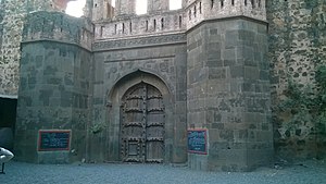
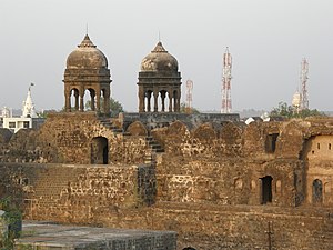
Malegaon Fort
Fort in Malegaon, Maharashtra
Distance: Approx. 624 meters
Latitude and longitude: 20.54538889,74.52988889
Malegaon Fort is a land fort located in the town of Malegaon. It is located 104 km from Nashik, in Nashik district, of Maharashtra. The fort is on the north bank of the Mausam river, which is a tributary of the Girna river.
Weather in this IP's area
clear sky
22 Celsius
21 Celsius
22 Celsius
22 Celsius
1013 hPa
36 %
1013 hPa
960 hPa
10000 meters
2 m/s
2.06 m/s
49 degree