Country:
Region:
City:
Latitude and Longitude:
Time Zone:
Postal Code:
IP information under different IP Channel
ip-api
Country
Region
City
ASN
Time Zone
ISP
Blacklist
Proxy
Latitude
Longitude
Postal
Route
Luminati
Country
ASN
Time Zone
Asia/Hong_Kong
ISP
Pittqiao Network Information Co.,Ltd.
Latitude
Longitude
Postal
IPinfo
Country
Region
City
ASN
Time Zone
ISP
Blacklist
Proxy
Latitude
Longitude
Postal
Route
db-ip
Country
Region
City
ASN
Time Zone
ISP
Blacklist
Proxy
Latitude
Longitude
Postal
Route
ipdata
Country
Region
City
ASN
Time Zone
ISP
Blacklist
Proxy
Latitude
Longitude
Postal
Route
Popular places and events near this IP address

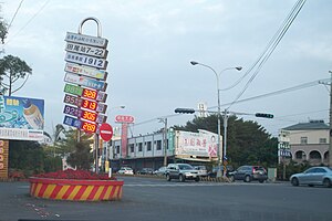
Changhua County
County in Taiwan Province, Republic of China
Distance: Approx. 6155 meters
Latitude and longitude: 23.93333333,120.53333333
Changhua County (Mandarin Pinyin: Zhānghuà Xiàn; Wade-Giles: Chang¹-hua⁴ Hsien⁴; Hokkien POJ: Chiang-hòa-koān or Chiong-hòa-koān) is the smallest county on the main island of Taiwan by area, and the fourth smallest in the country. With a total population of 1.24 million, Changhua County is the most populous county in the Republic of China. Its capital is Changhua City and it is part of the Taichung–Changhua metropolitan area.
Beidou, Changhua
Urban township
Distance: Approx. 633 meters
Latitude and longitude: 23.8747,120.5248
Beidou Township (Chinese: 北斗鎮; pinyin: Běidǒu Zhèn; Pe̍h-ōe-jī: Pak-táu-tìn) is an urban township in Changhua County, Taiwan.

Changhua HSR station
Railway station in Changhua, Taiwan
Distance: Approx. 5483 meters
Latitude and longitude: 23.8743,120.5746
Changhua (Chinese: 彰化; pinyin: Zhānghuà) is a railway station in Changhua County, Taiwan served by Taiwan High Speed Rail.

Shetou railway station
Railway station located in Changhua, Taiwan
Distance: Approx. 6318 meters
Latitude and longitude: 23.89572222,120.58038889
Shetou (Chinese: 社頭車站; pinyin: Shètóu Chēzhàn) is a railway station on the Taiwan Railways Administration West Coast line located in Shetou Township, Changhua County, Taiwan.
Pitou, Changhua
Rural township in Changhua, Taiwan
Distance: Approx. 5138 meters
Latitude and longitude: 23.8775,120.47055556
Pitou Township (Chinese: 埤頭鄉; pinyin: Pítóu Xiāng) is a rural township in Changhua County, Taiwan. The district had a population of 29,314 as of January 2023 and an area of 42.75 square kilometres (16.51 sq mi). One of the attractions in Pitou is the Kopok Flower Boulevard.

Tianwei
Rural township
Distance: Approx. 2576 meters
Latitude and longitude: 23.90233333,120.52141667
Tianwei Township (Chinese: 田尾鄉; pinyin: Tiánwěi Xiāng) is a rural township in Changhua County, Taiwan. It has a population total of 26,063 and an area of 24.03 square kilometres.

Yongjing, Changhua
Rural township in Changhua County, Taiwan
Distance: Approx. 5019 meters
Latitude and longitude: 23.92227778,120.53555556
Yongjing Township is a rural township in Changhua County, Taiwan.
MingDao University
University in Pitou, Changhua County, Taiwan
Distance: Approx. 2828 meters
Latitude and longitude: 23.8705,120.4949
MingDao University (MDU; Chinese: 明道大學; Pe̍h-ōe-jī: Bêng-tō Tāi-ha̍k) was a private university located in Pitou Township, Changhua County, Taiwan. MingDao's specialized areas of research include renewable energy engineering (especially solar, wind, and hydrogen), and its Department of Post Modern Agriculture is active in the promotion of organic agriculture across East and Southeast Asia.

Changhua Fitzroy Gardens
Garden in Xizhou, Changhua County, Taiwan
Distance: Approx. 4807 meters
Latitude and longitude: 23.84205556,120.49691667
The Changhua Xizhou Gardens (traditional Chinese: 溪州公園; simplified Chinese: 溪州公园; pinyin: Xīzhōu Gōngyuán) is a garden in Xizhou Township, Changhua County, Taiwan.

Yusan Hall
Former residence in Yongjing, Changhua County, Taiwan
Distance: Approx. 4289 meters
Latitude and longitude: 23.91272222,120.54177778
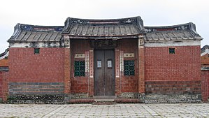
The Yusan Hall (traditional Chinese: 餘三館; simplified Chinese: 余三馆; pinyin: Yúsān Guǎn) is private mansion in Yongjing Township, Changhua County, Taiwan.
Changhua–Kaohsiung Viaduct
Bridge in Taiwan
Distance: Approx. 4226 meters
Latitude and longitude: 23.8645,120.55927778
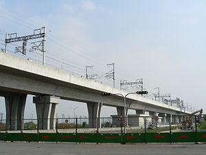
The Changhua–Kaohsiung Viaduct (Chinese: 彰化-高雄高架橋) is the world's second longest bridge. The bridge acts as an overland viaduct for part of the railway line of the Taiwan High Speed Rail network. Over 200 million passengers had been carried over it by December 2012.

Dian'an Temple
Temple in Changhua County, Taiwan
Distance: Approx. 874 meters
Latitude and longitude: 23.8724,120.5253
Beidou Dian'an Temple (Chinese: 北斗奠安宮; pinyin: Běidǒu Diànān Gōng) is a temple located in Beidou Township, Changhua County, Taiwan. The temple is dedicated to the sea goddess Mazu, who is the deified form of Lin Moniang.
Weather in this IP's area
overcast clouds
25 Celsius
26 Celsius
25 Celsius
27 Celsius
1007 hPa
82 %
1007 hPa
1003 hPa
10000 meters
2.51 m/s
3.39 m/s
356 degree
100 %
06:12:50
17:12:24


