Country:
 Japan
JapanRegion:
City:
Latitude and Longitude:
Time Zone:
Postal Code:
IP information under different IP Channel
ip-api
Country
Region
City
ASN
Time Zone
ISP
Blacklist
Proxy
Latitude
Longitude
Postal
Route
IPinfo
Country
Region
City
ASN
Time Zone
ISP
Blacklist
Proxy
Latitude
Longitude
Postal
Route
MaxMind
Country
Region
City
ASN
Time Zone
ISP
Blacklist
Proxy
Latitude
Longitude
Postal
Route
Luminati
Country
JPRegion
12
City
chiba
ASN
Time Zone
Asia/Tokyo
ISP
Research Organization of Information and Systems, National Institute of Informatics
Latitude
Longitude
Postal
db-ip
Country
Region
City
ASN
Time Zone
ISP
Blacklist
Proxy
Latitude
Longitude
Postal
Route
ipdata
Country
Region
City
ASN
Time Zone
ISP
Blacklist
Proxy
Latitude
Longitude
Postal
Route
Popular places and events near this IP address

Chiba Prefecture
Prefecture of Japan
Distance: Approx. 412 meters
Latitude and longitude: 35.605,140.12333333
Chiba Prefecture (千葉県, Chiba-ken) is a prefecture of Japan located in the Kantō region of Honshu. Chiba Prefecture has a population of 6,278,060 (1 June 2019) and has a geographic area of 5,157 km2 (1,991 sq mi). Chiba Prefecture borders Ibaraki Prefecture to the north, Saitama Prefecture to the northwest, and Tokyo to the west.

Hon-Chiba Station
Railway station in Chiba, Japan
Distance: Approx. 831 meters
Latitude and longitude: 35.60109167,140.12101667
Hon-Chiba station (本千葉駅, Hon-Chiba-eki) is a junction passenger railway station located in Chūō-ku, Chiba, Chiba Prefecture, Japan, operated by the East Japan Railway Company (JR East).

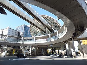
Sakaechō Station (Chiba)
Monorail station in Chiba, Japan
Distance: Approx. 1103 meters
Latitude and longitude: 35.613,140.11861111
Sakaechō Station (栄町駅, Sakaechō-eki) is a monorail station on the Chiba Urban Monorail in Chūō-ku in the city of Chiba, Chiba Prefecture, Japan. It is located 2.0 kilometers from the terminus of the line at Chiba Station.

Yoshikawa-kōen Station
Monorail station in Chiba, Japan
Distance: Approx. 733 meters
Latitude and longitude: 35.6086,140.12
Yoshikawa-kōen Station (葭川公園駅, Yoshikawa-kōen-eki) is a monorail station on the Chiba Urban Monorail in Chūō-ku in the city of Chiba, Chiba Prefecture, Japan. It is located 2.5 kilometers from the terminus at Chiba Station.
Kenchō-mae Station (Chiba)
Monorail station in Chiba, Japan
Distance: Approx. 572 meters
Latitude and longitude: 35.60365997,140.12217117
Kenchō-mae Station (県庁前駅, Kenchō-mae-eki) is a monorail station on the Chiba Urban Monorail in Chūō-ku in the city of Chiba, Chiba Prefecture, Japan. It is the terminus for Line 1 of the Chiba Urban Monorail and is located 3.2 kilometers from the opposite terminus at Chiba Station.

Higashi-Chiba Station
Railway station in Chiba, Japan
Distance: Approx. 1266 meters
Latitude and longitude: 35.61678056,140.12216111
Higashi-Chiba Station (東千葉駅, Higashi-Chiba-eki) is a passenger railway station located in Chūō-ku, Chiba, Chiba Prefecture, Japan, operated by East Japan Railway Company (JR East).

Keisei Chiba Station
Railway station in Chiba, Japan
Distance: Approx. 1337 meters
Latitude and longitude: 35.6117,140.1144
Keisei Chiba Station (京成千葉駅, Keisei Chiba-eki) is a railway station in Chūō-ku, Chiba, Japan, operated by the Keisei Electric Railway.

Chiba-Chūō Station
Railway station in Chiba, Japan
Distance: Approx. 898 meters
Latitude and longitude: 35.6075,140.11777778
Chiba-Chūō Station (千葉中央駅, Chiba-Chūō-eki) is a railway station operated by the Keisei Electric Railway located in Chūō-ku, Chiba Japan. It is 12.9 kilometers (8.0 mi) from the terminus of the Keisei Chiba Line at Keisei-Tsudanuma Station and is a terminal station for the Keisei Chihara Line.

Chiba-dera
Distance: Approx. 1297 meters
Latitude and longitude: 35.59513889,140.13169444
Chiba-dera (千葉寺, Chiba-dera), also known as Senyō-ji (千葉寺), is a Buddhist temple in the city of Chiba, Chiba Prefecture, Japan. The temple is located in the central Chūō District in the city of Chiba. Chiba-dera is one of many Buddhist temples in the region that, according to tradition, was established by the priest Gyōki (668–749).

Chiba Shrine
Shinto shrine in Chiba, Chiba Prefecture
Distance: Approx. 701 meters
Latitude and longitude: 35.61180556,140.12383333
Chiba Shrine (千葉神社, Chiba-jinja) is a Shinto shrine located in Chūō-ku, Chiba City, Chiba Prefecture. Originally a Buddhist temple dedicated to the deity Myōken, the patron of the Chiba clan, it was converted into a Shinto shrine dedicated to Ame-no-Minakanushi (a kami in Japanese mythology conflated with Myōken) during the Meiji period. Due to its historical status as one of the principal centers of Myōken worship in Chiba Prefecture associated with the Chiba clan, the shrine is also popularly known as Chiba Dai-Myōken (千葉大妙見, "Great Myōken [Shrine] of Chiba"), Myōken Hongū (妙見本宮, the ″Main Shrine (Hongū) of Myōken″), or simply as Myōken-sama (妙見様).

Natural History Museum and Institute, Chiba
Museum in Chiba, Japan
Distance: Approx. 1215 meters
Latitude and longitude: 35.599812,140.138389
The Natural History Museum and Institute, Chiba (千葉県立中央博物館, Chiba Kenritsu Chūō Hakubutsukan) is a prefectural museum in Chūō-ku, Chiba, Chiba Prefecture, Japan. The museum opened in 1989 with a focus on the natural history and history of the Bōsō Peninsula.
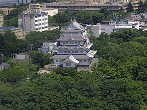
Inohana Castle
Ruined Japanese castle
Distance: Approx. 200 meters
Latitude and longitude: 35.60500817,140.12605147
Inohana Castle (亥鼻城, Inohana-jō) was a Japanese hirayama-style (lowland hill) castle located in Inohana (formerly Shimōsa Province) in the Chuo district of Chiba City, Chiba Prefecture. It is commonly known as Chiba Castle. The surrounding area of the castle ruins have been developed into Inohana Park.
Weather in this IP's area
few clouds
24 Celsius
24 Celsius
23 Celsius
24 Celsius
1022 hPa
67 %
1022 hPa
1021 hPa
10000 meters
2.32 m/s
5.26 m/s
165 degree
18 %
05:45:37
17:04:36