Country:
 Indonesia
Region:
City:
Latitude and Longitude:
Time Zone:
Postal Code:
IP information under different IP Channel
ip-api
Country
Region
City
ASN
Time Zone
ISP
Blacklist
Proxy
Latitude
Longitude
Postal
Route
IPinfo
Country
Region
City
ASN
Time Zone
ISP
Blacklist
Proxy
Latitude
Longitude
Postal
Route
MaxMind
Country
Region
City
ASN
Time Zone
ISP
Blacklist
Proxy
Latitude
Longitude
Postal
Route
Luminati
Country
IDASN
Time Zone
Asia/Jakarta
ISP
PT Digital Hasanah Indonesia
Latitude
Longitude
Postal
db-ip
Country
Region
City
ASN
Time Zone
ISP
Blacklist
Proxy
Latitude
Longitude
Postal
Route
ipdata
Country
Region
City
ASN
Time Zone
ISP
Blacklist
Proxy
Latitude
Longitude
Postal
Route
Popular places and events near this IP address
Cilandak
District of South Jakarta, Indonesia
Distance: Approx. 300 meters
Latitude and longitude: -6.29222222,106.79444444
Cilandak (Sundanese: ᮎᮤᮜᮔ᮪ᮓᮊ᮪) is a district (Indonesian: kecamatan) in the administrative city of South Jakarta, Indonesia. The Krukut River flows through the eastern edge of Cilandak, while the Pesanggrahan and Grogol Rivers flow through the western edge. The southern portion of the Jakarta Outer Ring Road passes through the district.

South Jakarta
Administrative city in Jakarta, Indonesia
Distance: Approx. 2721 meters
Latitude and longitude: -6.26861111,106.80611111
South Jakarta (Indonesian: Jakarta Selatan; Betawi: Jakarte Beludik), abbreviated as Jaksel, is one of the five administrative cities which form the Special Capital Region of Jakarta, Indonesia. South Jakarta is not self-governed and does not have a city council, hence it is not classified as a proper municipality. It covers a land area of 141.27 km2 (54.54 sq.miles), and had a population of 2,062,232 at the 2010 census and 2,226,812 at the 2020 census, and 2,409,380 as at mid 2022 according to the official estimates (comprising 1,200,090 males and 1,205,990 females).

Pondok Indah
Residential area in Jakarta, Indonesia
Distance: Approx. 1754 meters
Latitude and longitude: -6.28333333,106.78333333
Pondok Indah is an upscale residential area in Pondok Pinang, Kebayoran Lama, South Jakarta, Indonesia. It is one of the most prestigious suburb areas in Jakarta, and even in Indonesia. Pondok Indah is a much sought-after suburb by expatriates, conglomerates, celebrities, and government officials.
Al-Izhar Pondok Labu
Islamic school in South Jakarta, Indonesia
Distance: Approx. 2153 meters
Latitude and longitude: -6.31,106.792
Al-Izhar Pondok Labu (AIPL) is a moderate Islamic K-12 school in Pondok Labu, South Jakarta, Indonesia. It consists of a kindergarten, primary school, junior secondary school and senior secondary school. It is a National Plus school and the language of instruction is Indonesian.
Jeruk Purut Cemetery
Cemetery in Jakarta, Indonesia
Distance: Approx. 2311 meters
Latitude and longitude: -6.28002778,106.81452778
Jeruk Purut is a cemetery in Jakarta, Indonesia.
Reksa Artha Museum
History museum in Jl. Lebak Bulus I no. , Jakarta
Distance: Approx. 643 meters
Latitude and longitude: -6.296482,106.794408
The Reksa Artha Museum (Indonesian: Museum Reksa Artha) is a history museum located in Jakarta, Indonesia. The museum has a collection of historic items related to the printing of Indonesian rupiah. Some of its collection are historic Rupiah banknotes from the independence period until the Orde Baru era, 20th century money printers, coin making tools and historic pictures about the ORI (Oeang Republic of Indonesia) which in the past was used to maintain economic sovereignty in the early independence.
Basoeki Abdullah Museum
Art museum in South Jakarta, Indonesia
Distance: Approx. 437 meters
Latitude and longitude: -6.2897,106.7934
Basoeki Abdullah Museum (Indonesian: Museum Basoeki Abdullah) is an art museum located in South Jakarta, Indonesia. It contains paintings and the personal collection of Basoeki Abdullah, including statues, masks, puppets, and weapons. The museum is managed by the Ministry of Education and Culture.
Kites Museum of Indonesia
Distance: Approx. 1968 meters
Latitude and longitude: -6.3078,106.79059
The Kites Museum of Indonesia (Museum Layang-Layang Indonesia) is a museum in Pondok Labu, South Jakarta. It is the first kites museum in Indonesia. Its collection includes more than 600 kites.
LIFE School Jakarta
French international school in Indonesia
Distance: Approx. 1729 meters
Latitude and longitude: -6.2763,106.801
LIFE School Jakarta a.k.a. Lycée français de Jakarta, formerly known as the Lycée Français Louis-Charles Damais and the Lycée international français de Jakarta (LIF Jakarta), is a French international school in Jakarta, Indonesia. It serves levels preschool (maternelle) through high school (lycée).

Lebak Bulus Grab MRT station
MRT station in Jakarta, Indonesia
Distance: Approx. 2452 meters
Latitude and longitude: -6.289254,106.774937
Lebak Bulus MRT Station (or Lebak Bulus Grab MRT Station, with Grab granted for naming rights) is a rapid transit station on the North-South Line of the Jakarta MRT in Jakarta, Indonesia. The station is located in Lebak Bulus, Cilandak, South Jakarta and has only two railway lines, both of which are straight lines. The station is located not far from Lebak Bulus Terminal.

Fatmawati Indomaret MRT station
MRT station in Jakarta, Indonesia
Distance: Approx. 517 meters
Latitude and longitude: -6.292429,106.792466
Fatmawati MRT Station, or Fatmawati Indomaret MRT Station for sponsorship reason, is a rapid transit station on the M1 North-South Line of the Jakarta MRT in Jakarta, Indonesia. Located in South Jakarta, it is the penultimate station on the M1 North-South Line, located between Lebak Bulus Grab Station (Terminus) to the west and Cipete Raya (towards Bundaran HI) station to the northeast. The station is named after Fatmawati Central Public Hospital (Indonesian: Rumah Sakit Umum Pusat Fatmawati or RSUP Fatmawati) nearby; which in turn is named after Fatmawati, the third wife of the first president of Indonesia Sukarno and the inaugural First Lady of Indonesia.
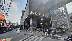
Cipete Raya MRT station
MRT station in Jakarta, Indonesia
Distance: Approx. 1549 meters
Latitude and longitude: -6.2774,106.7975
Cipete Raya Station is a rapid transit station on the North-South Line of the Jakarta MRT in Jakarta, Indonesia. The station is located on Jalan RS Fatmawati, Gandaria Selatan, Cilandak, South Jakarta, between Haji Nawi and Fatmawati Indomaret stations, and has the station code CPR. Close to the station is Jalan Cipete Raya (Cipete Raya Street), hence its name.
Weather in this IP's area
broken clouds
30 Celsius
33 Celsius
29 Celsius
32 Celsius
1014 hPa
58 %
1014 hPa
1009 hPa
6000 meters
3.09 m/s
240 degree
78 %
05:29:24
17:45:28