103.175.109.91 - IP Lookup: Free IP Address Lookup, Postal Code Lookup, IP Location Lookup, IP ASN, Public IP
Country:
Region:
City:
Location:
Time Zone:
Postal Code:
IP information under different IP Channel
ip-api
Country
Region
City
ASN
Time Zone
ISP
Blacklist
Proxy
Latitude
Longitude
Postal
Route
Luminati
Country
ASN
Time Zone
Asia/Kolkata
ISP
Rainbow communications India Pvt Ltd
Latitude
Longitude
Postal
IPinfo
Country
Region
City
ASN
Time Zone
ISP
Blacklist
Proxy
Latitude
Longitude
Postal
Route
IP2Location
103.175.109.91Country
Region
tamil nadu
City
salem
Time Zone
Asia/Kolkata
ISP
Language
User-Agent
Latitude
Longitude
Postal
db-ip
Country
Region
City
ASN
Time Zone
ISP
Blacklist
Proxy
Latitude
Longitude
Postal
Route
ipdata
Country
Region
City
ASN
Time Zone
ISP
Blacklist
Proxy
Latitude
Longitude
Postal
Route
Popular places and events near this IP address

Salem, Tamil Nadu
City in Tamil Nadu, India
Distance: Approx. 1810 meters
Latitude and longitude: 11.65,78.15
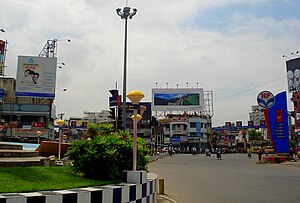
Salem, natively spelt as Selam (pronounced [seːlam] ), is a major city in Salem district, located on the banks of the Thirumanimutharu river in the Indian state of Tamil Nadu surrounded by mountains. Salem is the fifth largest urban agglomeration in the state, exceeded by Chennai, Coimbatore, Madurai, Tiruchirappalli, and Third largest metropolitan region in the state only after to Chennai and Coimbatore metropolitan regions. The city is 124 km2 (48 sq mi) large.
Salem district
District of Tamil Nadu in India
Distance: Approx. 2772 meters
Latitude and longitude: 11.6646,78.146
Salem District is one of the 38 districts of Tamil Nadu state in southern India. The district is now divided into Dharmapuri, Krishnagiri, Namakkal as individual districts. Salem is the district headquarters and other major towns in the district include Mettur, Tharamangalam, Thammampatti, Attur, Omalur, Sangagiri and Edappadi.

Salem Lok Sabha constituency
One of the 39 Parliamentary Constituencies in Tamil Nadu, in India.
Distance: Approx. 2869 meters
Latitude and longitude: 11.67,78.15
Salem is a parliamentary (Lok Sabha) constituency in Tamil Nadu, India. Its Tamil Nadu Parliamentary Constituency number is 15 of 39. It includes 6 Assembly constituencies like Edappadi, Omalur, Salem North, Salem South, Salem West and Veerapandi.

Roman Catholic Diocese of Salem
Latin Catholic diocese in India
Distance: Approx. 2864 meters
Latitude and longitude: 11.6645,78.1449
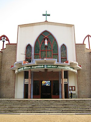
The Diocese of Salem (Latin: Salemen(sis)) is a Latin Church ecclesiastical jurisdiction or diocese of the Catholic Church in India. Its episcopal see is Salem. The Diocese of Salem is a suffragan in the ecclesiastical province of the metropolitan Archdiocese of Pondicherry and Cuddalore.

Attur Assembly constituency
State Legislative Assembly Constituency in Tamil Nadu, India
Distance: Approx. 2257 meters
Latitude and longitude: 11.63,78.17
Attur is a state legislative assembly constituency in Salem district in the Indian state of Tamil Nadu. Its State Assembly Constituency number is 82. It comprises a portion of Attur taluk, which includes the city of Attur.
Christ Church, Salem
Church in Salem, India
Distance: Approx. 1378 meters
Latitude and longitude: 11.6558571,78.1554634
Christ Church is located on Fort Road, near the District Collectorate, in the heart of Salem City, Tamil Nadu, India. The church has been serving the community for the last 140 years, since its consecration in 1875. The church services at Christ Church are conducted both in English and Tamil.
Mahatma Gandhi Stadium
Distance: Approx. 1842 meters
Latitude and longitude: 11.6602,78.1533
Mahatma Gandhi Stadium is a sports stadium in Salem, Tamil Nadu. The stadium has hosted seven first-class matches from 1973 when Tamil Nadu cricket team played against Kerala cricket team. The ground hosted its last first-class matches in 1992 when Tamil Nadu cricket team played against Andhra cricket team.
Bharat Ratna Dr. M.G.R. Central Bus Stand
Distance: Approx. 3266 meters
Latitude and longitude: 11.6673,78.1424
Bharat Ratna Dr. M.G.R. Central Bus Stand, commonly known as Salem Central Bus Stand, is one of the bus terminus of Salem other being the Town Bus Terminus Salem City.
Double Decker City Bus Terminus, Salem
Distance: Approx. 875 meters
Latitude and longitude: 11.6528,78.1591
Town Bus Terminus Salem popularly known as Old Bus Stand, Salem, is the main Town bus terminus of Salem City in the Indian state of Tamil Nadu. The terminal spreads over 3.5 acres (1.4 ha). It is managed by Department of Transport.

Government Arts College, Salem
Art school in Salem, Tamil Nadu
Distance: Approx. 1758 meters
Latitude and longitude: 11.663554,78.15832
Government Arts College, Salem, is an autonomous college in Salem, Tamil Nadu, India.
Omlaur Main Road
Road in Salem, India
Distance: Approx. 3421 meters
Latitude and longitude: 11.668891,78.141853
Omlaur Main Road, is an arterial road in Salem, India. Omlaur Main Road runs from Salem District Collectorate to Kuranguchavadi, it connects National Highway 44 (Srinagar - Kanyakumari via Salem) from the centre of the city. This road connecting Salem airport through NH 44 with Bharat Ratna Dr.
Ammapet
Town in Tamil Nadu, India
Distance: Approx. 2362 meters
Latitude and longitude: 11.6548,78.1877
Ammapet also called as "Ammapettai" is a town in Salem district of Tamil Nadu state in India.
Weather in this IP's area
broken clouds
24 Celsius
24 Celsius
24 Celsius
24 Celsius
1011 hPa
92 %
1011 hPa
960 hPa
10000 meters
0.3 m/s
0.33 m/s
340 degree
81 %

