103.172.47.224 - IP Lookup: Free IP Address Lookup, Postal Code Lookup, IP Location Lookup, IP ASN, Public IP
Country:
Region:
City:
Location:
Time Zone:
Postal Code:
ISP:
ASN:
language:
User-Agent:
Proxy IP:
Blacklist:
IP information under different IP Channel
ip-api
Country
Region
City
ASN
Time Zone
ISP
Blacklist
Proxy
Latitude
Longitude
Postal
Route
db-ip
Country
Region
City
ASN
Time Zone
ISP
Blacklist
Proxy
Latitude
Longitude
Postal
Route
IPinfo
Country
Region
City
ASN
Time Zone
ISP
Blacklist
Proxy
Latitude
Longitude
Postal
Route
IP2Location
103.172.47.224Country
Region
rajasthan
City
hanumangarh
Time Zone
Asia/Kolkata
ISP
Language
User-Agent
Latitude
Longitude
Postal
ipdata
Country
Region
City
ASN
Time Zone
ISP
Blacklist
Proxy
Latitude
Longitude
Postal
Route
Popular places and events near this IP address

Hanumangarh
City in Rajasthan, India
Distance: Approx. 487 meters
Latitude and longitude: 29.58,74.32
Hanumangarh is a city and municipal council in the Indian state of Rajasthan, situated on the banks of the river Ghaggar also identified as ancient Sarasvati river, located about 400 km from Delhi. It is the administrative headquarter of Hanumangarh District. The city was once called Bhatner (alternatively spelled Bhatnair) because it was founded by king Bhupat in 255 AD. It remained in the control of the Rajputs of Bhati clan and faced a historic siege by Timur in 1391, during which the Bhati Raput king Dulachand lost the fort for a short time.

Hanumangarh district
District in Rajasthan, India
Distance: Approx. 487 meters
Latitude and longitude: 29.58,74.32
Hanumangarh district is a district in the state of Rajasthan in India. The city of Hanumangarh is the district headquarters and its largest city.

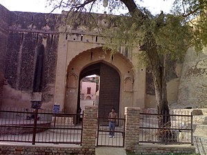
Bhatner fort
Ancient Indian fortress
Distance: Approx. 906 meters
Latitude and longitude: 29.5863,74.3254
The Bhatner Fort was built by son of Rao Bhatti, about 419 km northwest of Jaipur along the old Multan-Delhi route and 230 km north-east of Bikaner. Another name of Hanumangarh was Bhatner, which means "fortress of the Bhati". Believed to be 1700 years old, it is considered to be one of the oldest forts of India.
Hanumangarh Assembly constituency
Constituency of the Rajasthan legislative assembly in India
Distance: Approx. 1339 meters
Latitude and longitude: 29.58,74.33
Hanumangarh Assembly constituency is one of constituencies of Rajasthan Legislative Assembly in the Ganganagar (Lok Sabha constituency). Hanumangarh Constituency covers all voters from part of Hanumangarh tehsil, which includes ILRC Hanumangarh including Hanumangarh Municipal Board, ILRC Ronawali,ILRC Pucca Sarnan, IIRC Fatehgarh, ILRC Lakhuwali and ILRC Norangdesar.
Hanumangarh Junction railway station
Railway Station in Rajasthan, India
Distance: Approx. 3872 meters
Latitude and longitude: 29.6117,74.2936
Hanumangarh Junction railway station is a main railway station in Hanumangarh district, Rajasthan. Its code is HMH. It serves Hanumangarh city. Hanumangarh is a major railway station on Jodhpur–Bathinda line, Sadulpur, Rewari, Jaipur, Sriganganagar, Anupgarh.
Hanumangarh Town railway station
Railway Station in Rajasthan, India
Distance: Approx. 1734 meters
Latitude and longitude: 29.5744,74.3314
Hanumangarh Town railway station is a small railway station in Hanumangarh district, [Rajasthan]. Its code is HMO. It serves Hanumangarh city. The station consists of two platforms.
Weather in this IP's area
clear sky
19 Celsius
17 Celsius
19 Celsius
19 Celsius
1019 hPa
17 %
1019 hPa
997 hPa
10000 meters
3.62 m/s
5.03 m/s
329 degree