Country:
 India
IndiaRegion:
City:
Latitude and Longitude:
Time Zone:
Postal Code:
IP information under different IP Channel
ip-api
Country
Region
City
ASN
Time Zone
ISP
Blacklist
Proxy
Latitude
Longitude
Postal
Route
IPinfo
Country
Region
City
ASN
Time Zone
ISP
Blacklist
Proxy
Latitude
Longitude
Postal
Route
MaxMind
Country
Region
City
ASN
Time Zone
ISP
Blacklist
Proxy
Latitude
Longitude
Postal
Route
Luminati
Country
 ES
ESRegion
ct
City
blanes
ASN
Time Zone
Europe/Madrid
ISP
Ideastack Solutions Private Limited
Latitude
Longitude
Postal
db-ip
Country
Region
City
ASN
Time Zone
ISP
Blacklist
Proxy
Latitude
Longitude
Postal
Route
ipdata
Country
Region
City
ASN
Time Zone
ISP
Blacklist
Proxy
Latitude
Longitude
Postal
Route
Popular places and events near this IP address

Jogeshwari
Suburb of Mumbai, India
Distance: Approx. 794 meters
Latitude and longitude: 19.12,72.85
Jogeshwari (Pronunciation: [d͡ʒoɡeːʃʋəɾiː]) is a suburb located in the western part of Mumbai, Maharashtra, India. It is notable for its caves - 'Jogeshwari Caves', particularly one containing a shrine of the Hindu Goddess Jogeshwari, Lord Shiva and the deity Hanuman. It belongs to the K/E Ward of Mumbai.
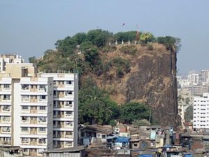
Gilbert Hill
Monolith column of black basalt rock at Andheri, in Mumbai, India
Distance: Approx. 403 meters
Latitude and longitude: 19.12083333,72.84006667
Gilbert Hill is a 200 ft (61 m) monolith column of black basalt rock at Andheri, in Mumbai, India. The rock has a sheer vertical face and was formed when molten lava was squeezed out of the Earth's clefts during the Mesozoic Era about 66 million years ago. During that era, molten lava had spread around most of the Indian states of Maharashtra, Gujarat and Madhya Pradesh, covering an area of 50,000 square kilometres (19,000 sq mi).
Andheri
Suburb in Mumbai Suburban, Maharashtra, India
Distance: Approx. 461 meters
Latitude and longitude: 19.119,72.847
Andheri ([ən̪d̪ʱeɾiː]) is a suburb situated in Western Mumbai, Maharashtra, India.
Amboli, Mumbai
Neighbourhood in Mumbai Suburban, Maharashtra, India
Distance: Approx. 1238 meters
Latitude and longitude: 19.1293,72.8434
Amboli is in Andheri (West), Mumbai, Maharashtra. Earlier known as Ambolim, it is situated very close to Andheri railway station and Jogeshwari railway station. At its heart, it also has a playground known as Joe and Helen Ground.
Irla
Neighbourhood in Mumbai, Maharashtra, India
Distance: Approx. 1230 meters
Latitude and longitude: 19.10805556,72.83805556
Irla is a neighbourhood in suburban Mumbai, part of Vile Parle. It is located near the upmarket Juhu area. There is one beautiful Jain temple of the first Tirthankar of Jains, Adinath.
St. Blaise High School
Government school, catholic, co-ed school in Mumbai, Maharashtra, India
Distance: Approx. 1077 meters
Latitude and longitude: 19.12722222,72.84638889
St. Blaise is a school founded in 1879 and is run by the Roman Catholic parish of St. Blaise, Amboli in the Indian state of Maharashtra.

Bhavan's College
Distance: Approx. 1044 meters
Latitude and longitude: 19.125023,72.835885
Bhavan's College is a college located in Andheri West, a neighborhood in western Mumbai, India. It was established in 1946, a year before India gained independence from the British in 1947. K. M. Munshi was the founding president of the college.

Andheri railway station
Railway station in Maharashtra, India
Distance: Approx. 459 meters
Latitude and longitude: 19.119167,72.846944
Andheri (station code: A (Western)/AD (Harbour)/ADH (Indian Railways)) is a passenger rail station located at Andheri suburb of Mumbai. It serves the Western line and Harbour lines of the Mumbai Suburban Railway. It is also a stop for some express trains and August Kranti Rajdhani Express.

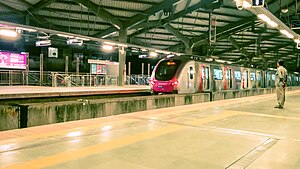
Andheri metro station
Mumbai Metro's Blue Line 1 metro station
Distance: Approx. 621 meters
Latitude and longitude: 19.12055556,72.84805556
Andheri is an elevated metro station on the East-West Corridor of the Blue Line 1 of Mumbai Metro serving the Andheri suburb of Mumbai, India. It was opened to the public on 8 June 2014. After Ghatkopar, Andheri is the busiest station on Line 1, with a daily passenger traffic of 72,125 in February 2017.
Azad Nagar metro station
Mumbai Metro's Blue Line 1 metro station
Distance: Approx. 1097 meters
Latitude and longitude: 19.1269,72.8378
Azad Nagar (officially known as Medimix Azad Nagar) is an elevated metro station on the East-West Corridor of the Blue Line 1 of Mumbai Metro serving the Azad Nagar neighbourhood of Andheri in Mumbai, India. It opened to the public on 8 June 2014.
Mogra Village
Village in Maharashtra
Distance: Approx. 1119 meters
Latitude and longitude: 19.126589,72.848558
Mogra Village also known as Mogre Pada is a small area in Mumbai, Maharashtra, India, which lies in the suburb of Mumbai near Andheri East Station Nearest railway station – Andheri East Known Area :- Saduwada, Raja Nagar, Khachad etc.
Andheri Assembly constituency
Former constituency of the Maharashtra legislative assembly in India
Distance: Approx. 1086 meters
Latitude and longitude: 19.124,72.851
Andheri Vidhan Sabha seat was one of the constituencies of Maharashtra Legislative Assembly, in India. Andheri seat existed until the 2004 elections after which it became defunct when the map of constituencies in India was redrawn. In 2008, two new Vidhan Sabha seats (Andheri East and Andheri West) were created covering this area.
Weather in this IP's area
haze
31 Celsius
37 Celsius
31 Celsius
31 Celsius
1008 hPa
70 %
1008 hPa
1006 hPa
5000 meters
5.14 m/s
240 degree
40 %
06:33:56
18:12:53