Country:
 Indonesia
Region:
City:
Latitude and Longitude:
Time Zone:
Postal Code:
IP information under different IP Channel
ip-api
Country
Region
City
ASN
Time Zone
ISP
Blacklist
Proxy
Latitude
Longitude
Postal
Route
IPinfo
Country
Region
City
ASN
Time Zone
ISP
Blacklist
Proxy
Latitude
Longitude
Postal
Route
MaxMind
Country
Region
City
ASN
Time Zone
ISP
Blacklist
Proxy
Latitude
Longitude
Postal
Route
Luminati
Country
IDRegion
ji
City
surabaya
ASN
Time Zone
Asia/Jakarta
ISP
PT Media Sarana Data
Latitude
Longitude
Postal
db-ip
Country
Region
City
ASN
Time Zone
ISP
Blacklist
Proxy
Latitude
Longitude
Postal
Route
ipdata
Country
Region
City
ASN
Time Zone
ISP
Blacklist
Proxy
Latitude
Longitude
Postal
Route
Popular places and events near this IP address

Surabaya
Capital and largest city of East Java, Indonesia
Distance: Approx. 537 meters
Latitude and longitude: -7.24583333,112.73777778
Surabaya is the capital city of the Indonesian province of East Java and the second-largest city in Indonesia, after Jakarta. Located on the northeastern corner of Java island, on the Madura Strait, it is one of the earliest port cities in Southeast Asia. According to the National Development Planning Agency, Surabaya is one of the four main central cities of Indonesia, alongside Jakarta, Medan, and Makassar.
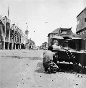
Battle of Surabaya
Battle between British and Indonesian forces
Distance: Approx. 1283 meters
Latitude and longitude: -7.25972222,112.73972222
The Battle of Surabaya was a major battle in the Indonesian National Revolution fought between regular infantry and militia of the Indonesian nationalist movement and British and British Indian troops against the re-imposition of Dutch colonial rule. The peak of the battle was in November 1945. The battle was the largest single battle of the revolution and became a national symbol of Indonesian resistance.

Hotel Majapahit
Hotel in East Java, Indonesia
Distance: Approx. 1283 meters
Latitude and longitude: -7.25972222,112.73972222
The Hotel Majapahit is a historic hotel in Surabaya, East Java, Indonesia, opened in 1911. The hotel is currently managed by Accor through its MGallery chain.
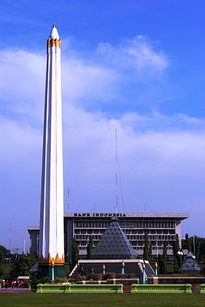
Heroes Monument
Monument in Surabaya
Distance: Approx. 549 meters
Latitude and longitude: -7.24611111,112.7375
The Heroes Monument (Indonesian: Tugu Pahlawan) is a monument in Surabaya, East Java, Indonesia. It is the main symbol of the city, dedicated to the people who died during the Battle of Surabaya on 10 November 1945. The 10 November Museum is located under the monument.

Surabaya Pasar Turi railway station
Railway station in Indonesia
Distance: Approx. 1192 meters
Latitude and longitude: -7.24805556,112.73111111
Surabaya Pasar Turi Station or Surabaya Pasarturi Station (SBI) is the second largest railway station in Surabaya, East Java. It is located near the Pasar Turi market in Bubutan, Surabaya. It is the main departure point of all train from Surabaya which passes through Pantura to the western cities of Java such as Jakarta and Semarang, but trains south and east line from Surabaya departed from Surabaya Gubeng.

Mas River
Distance: Approx. 1360 meters
Latitude and longitude: -7.23672778,112.73825556
The Kali Mas ("Golden River" in Javanese), also known as Kali Surabaya, is a distributary of the Brantas River in East Java, flowing north-easterly towards the Madura Strait. This river also forms part of the border between the Sidoarjo and Gresik regencies of East Java, Indonesia.
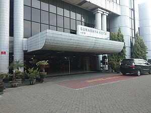
Surabaya Kota railway station
Railway station in Indonesia
Distance: Approx. 609 meters
Latitude and longitude: -7.243,112.741
Surabaya Kota Station (SB) is a railway station in Bongkaran, Pabean Cantikan, Surabaya, East Java, Indonesia. The local people usually call it Semut Station.

Church of the Birth of Our Lady, Surabaya
Catholic church in Indonesia
Distance: Approx. 904 meters
Latitude and longitude: -7.242204,112.736615
The Church of the Birth of Our Lady, also known as the Kepanjen Church, is a Roman Catholic church in Surabaya, East Java, Indonesia. Completed in 1899, it is the oldest Roman Catholic church in Surabaya and among the oldest churches in Surabaya.

Surabaya City Hall
City Hall in Surabaya, Indonesia
Distance: Approx. 1334 meters
Latitude and longitude: -7.259257,112.747003
Surabaya City Hall (Indonesian: Balai Kota Surabaya) is the administrative center of the city of Surabaya. The building was built by Cosman Citroen in the 1920s. The building is one of the example of 20th century buildings designed in a tropical-conscious climate of Indonesia, the style is known as the New Indies Style.
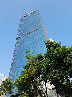
Pakuwon Jati
Indonesian real estate developer
Distance: Approx. 1469 meters
Latitude and longitude: -7.26111111,112.73833333
PT Pakuwon Jati Tbk is an Indonesian real estate developer based in Surabaya and the holding company of Pakuwon Group. Pakuwon Group was founded by Alexander Tedja in 1982. This organization centralizes on the construction of shopping centres and office buildings in Surabaya and Jakarta.
Maspion
Indonesian multinational company
Distance: Approx. 1182 meters
Latitude and longitude: -7.237887,112.743396
Maspion Holdings Corporation, also known as the Maspion Group or simply known as Maspion (stylized as MASPION), is a group of autonomous Indonesian conglomerate and multinational companies, based in Surabaya, East Java. It was founded by Alim Husin in 1962. The company employs around 30,000 people (2016) and has 44 subsidiaries.
Alumindo
Indonesian metal manufacturing
Distance: Approx. 1182 meters
Latitude and longitude: -7.237887,112.743396
PT Alumindo Light Metal Industry Tbk, or also known simply as Alumindo, is the largest flat rolled aluminium manufacturer in South East Asia, and a publicly-traded subsidiary of Maspion which was founded in 1978 and started to become a commercial company in 1983. The company is headquartered in Surabaya, East Java. Initially, each year the company was able to produce around 4,800 tons of aluminum sheet which is usually used as the main ingredient in the manufacture of household appliances, transportation equipment, as well as building materials.
Weather in this IP's area
haze
29 Celsius
33 Celsius
29 Celsius
29 Celsius
1013 hPa
74 %
1013 hPa
1013 hPa
5000 meters
2.06 m/s
60 degree
20 %
05:10:02
17:22:49