Country:
 Australia
Region:
City:
Latitude and Longitude:
Time Zone:
Postal Code:
IP information under different IP Channel
ip-api
Country
Region
City
ASN
Time Zone
ISP
Blacklist
Proxy
Latitude
Longitude
Postal
Route
IPinfo
Country
Region
City
ASN
Time Zone
ISP
Blacklist
Proxy
Latitude
Longitude
Postal
Route
MaxMind
Country
Region
City
ASN
Time Zone
ISP
Blacklist
Proxy
Latitude
Longitude
Postal
Route
Luminati
Country
AUASN
Time Zone
Australia/Sydney
ISP
TPG Telecom Limited
Latitude
Longitude
Postal
db-ip
Country
Region
City
ASN
Time Zone
ISP
Blacklist
Proxy
Latitude
Longitude
Postal
Route
ipdata
Country
Region
City
ASN
Time Zone
ISP
Blacklist
Proxy
Latitude
Longitude
Postal
Route
Popular places and events near this IP address

Wooloowin railway station
Railway station in Brisbane, Queensland, Australia
Distance: Approx. 636 meters
Latitude and longitude: -27.4199,153.0434
Wooloowin railway station is located on the North Coast line in Queensland, Australia. It serves the Brisbane suburb of Wooloowin.

Albion railway station, Brisbane
Railway station in Brisbane, Queensland, Australia
Distance: Approx. 461 meters
Latitude and longitude: -27.4291,153.0405
Albion railway station is located on the North Coast line in Queensland, Australia. It serves the Brisbane suburb of Albion. On 29 November 1999, two extra platforms opened as part of the quadruplication of the line from Bowens Hills to Northgate.
Albion, Queensland
Suburb of Brisbane, Queensland, Australia
Distance: Approx. 897 meters
Latitude and longitude: -27.4336,153.0441
Albion is an inner north-eastern suburb in the City of Brisbane, Queensland, Australia. In the 2021 census, Albion had a population of 3,446 people.

Wooloowin, Queensland
Suburb of Brisbane, Queensland, Australia
Distance: Approx. 671 meters
Latitude and longitude: -27.4197,153.0416
Wooloowin ( WUU-lə-wən) is a suburb in the City of Brisbane, Queensland, Australia. In the 2021 census, Wooloowin had a population of 4,029 people.
St Margaret's Anglican Girls' School
Independent, day, boarding school in Ascot, Queensland, Australia
Distance: Approx. 782 meters
Latitude and longitude: -27.43,153.04916667
St Margaret's Anglican Girls School is an Australian private Anglican day and boarding school for girls. The school is located in Ascot, an inner-northern suburb of Brisbane, Queensland. The school was founded in 1895 by the religious sisters of the Society of the Sacred Advent.
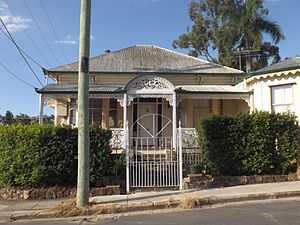
Dunaverty, Albion
Historic site in Queensland, Australia
Distance: Approx. 303 meters
Latitude and longitude: -27.4282,153.0421
Dunaverty is a heritage-listed detached house at 21 Birkbeck Street, Albion, City of Brisbane, Queensland, Australia. It was built in 1887 by Archibald McNish Fraser. It is also known as Carvarmore.
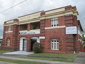
Albion Fire Station
Historic site in Queensland, Australia
Distance: Approx. 133 meters
Latitude and longitude: -27.4253,153.0417
Albion Fire Station is a heritage-listed former fire station at 42 Bridge Street, Wooloowin, City of Brisbane, Queensland, Australia. It was designed by Department of Public Works and built from 1925 to 1927. It was added to the Queensland Heritage Register on 28 February 2003.

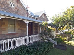
Holy Cross Laundry
Historic site in Queensland, Australia
Distance: Approx. 320 meters
Latitude and longitude: -27.4231,153.0414
Holy Cross Laundry is a heritage-listed benevolent institution at 60 Bridge Street, Wooloowin, City of Brisbane, Queensland, Australia. It was designed by Francis Drummond Greville Stanley and built from 1888 to 1905. It was also known as Magdalen Asylum.
Conon, Lutwyche
Historic site in Queensland, Australia
Distance: Approx. 702 meters
Latitude and longitude: -27.4245,153.036
Conon is a heritage-listed detached house at 29 Conon Street, Lutwyche, City of Brisbane, Queensland, Australia. It was built in 1863. It was added to the Queensland Heritage Register on 21 October 1992.

Killila
Historic site in Queensland, Australia
Distance: Approx. 684 meters
Latitude and longitude: -27.4261,153.0361
Killila is a heritage-listed detached house at 100 Stoneleigh Street, Lutwyche, City of Brisbane, Queensland, Australia. It was built c. 1885. It is also known as Killila Cottage.
Craigellachie, Windsor
Historic site in Queensland, Australia
Distance: Approx. 958 meters
Latitude and longitude: -27.4277,153.0336
Craigellachie is a heritage-listed detached house at 10 Fosbery Street, Windsor, City of Brisbane, Queensland, Australia. It was built c. 1889 by its owner John Grant, a stonemason. It was added to the Queensland Heritage Register on 21 October 1992.

Tarranalma
Historic site in Queensland, Australia
Distance: Approx. 517 meters
Latitude and longitude: -27.4251,153.0482
Tarranalma is a heritage-listed villa at 18 Tarranalma Avenue, Clayfield, City of Brisbane, Queensland, Australia. It was built in 1890. It was added to the Queensland Heritage Register on 21 October 1992.
Weather in this IP's area
overcast clouds
17 Celsius
17 Celsius
16 Celsius
18 Celsius
1020 hPa
94 %
1020 hPa
1017 hPa
10000 meters
1.34 m/s
3.13 m/s
187 degree
100 %
05:18:08
17:51:48