Country:
 The Philippines
Region:
City:
Latitude and Longitude:
Time Zone:
Postal Code:
IP information under different IP Channel
ip-api
Country
Region
City
ASN
Time Zone
ISP
Blacklist
Proxy
Latitude
Longitude
Postal
Route
IPinfo
Country
Region
City
ASN
Time Zone
ISP
Blacklist
Proxy
Latitude
Longitude
Postal
Route
MaxMind
Country
Region
City
ASN
Time Zone
ISP
Blacklist
Proxy
Latitude
Longitude
Postal
Route
Luminati
Country
PHRegion
40
City
taytay
ASN
Time Zone
Asia/Manila
ISP
EWS DS Networks Inc
Latitude
Longitude
Postal
db-ip
Country
Region
City
ASN
Time Zone
ISP
Blacklist
Proxy
Latitude
Longitude
Postal
Route
ipdata
Country
Region
City
ASN
Time Zone
ISP
Blacklist
Proxy
Latitude
Longitude
Postal
Route
Popular places and events near this IP address
Cainta
Municipality in Rizal, Philippines
Distance: Approx. 1008 meters
Latitude and longitude: 14.57,121.12
Cainta, officially the Municipality of Cainta (Filipino: Bayan ng Cainta, IPA: [kɐʔɪnˈtaʔ]), is a 1st class urban municipality in the province of Rizal, Philippines. According to the 2020 census, it has a population of 376,933 people. It is one of the oldest municipalities in Luzon (founded on August 15, 1571) and has a land area of 4,299 hectares (10,620 acres). Cainta serves as the secondary gateway to the rest of Rizal province from Metro Manila.

Taytay, Rizal
Municipality in Rizal, Philippines
Distance: Approx. 393 meters
Latitude and longitude: 14.56917,121.1325
Taytay, officially the Municipality of Taytay (Filipino: Bayan ng Taytay; IPA: [taɪˈtaɪ]), is a 1st class urban municipality in the province of Rizal, Philippines. It is also known as the Garments Capital of the Philippines. Conurbanated with Metro Manila, it is bounded by Cainta on the north, Pasig and Taguig on the west, Antipolo in the east and Angono on the south.
Asia-Pacific Nazarene Theological Seminary
Distance: Approx. 2080 meters
Latitude and longitude: 14.577649,121.145575
Asia-Pacific Nazarene Theological Seminary (APNTS) is a graduate-level theological institution located near Metro Manila in the Philippines. APNTS is a seminary in the Wesleyan theological tradition and affiliated with the Church of the Nazarene through its Division of World Mission. Its mission is to prepare "men and women for Christ-like leadership and excellence in ministries." Its institutional vision is: "Bridging cultures for Christ, APNTS equips each new generation of leaders to disseminate the gospel of Jesus Christ throughout Asia, the Pacific, and the world.

Mitsubishi Motors Philippines
Automotive manufacturer in the Philippines
Distance: Approx. 1590 meters
Latitude and longitude: 14.5821,121.1307
Mitsubishi Motors Philippines Corporation (MMPC) (formerly Philippine Automotive Manufacturing Corporation) is the Philippine operation of Mitsubishi Motors Corporation (MMC), where it is the second-biggest seller of automobiles. MMPC is one of MMC's four manufacturing facilities outside Japan, and currently produces the Mitsubishi Mirage, Mirage G4, and the L300. From 1987 to 2018, MMPC was the distributor of Mitsubishi Fuso commercial vehicles in the Philippines until Sojitz Fuso Philippines Corporation was established in September 2018.
Siena College of Taytay
Roman Catholic college in Rizal, Philippines
Distance: Approx. 393 meters
Latitude and longitude: 14.56916667,121.1325
Siena College of Taytay, also referred to by its acronym SCT, is a private, non-profit Catholic basic and higher education institution run by the Congregation of the Dominican Sisters of St. Catherine of Siena in Taytay, Rizal, Philippines. It was named St.
Casimiro A. Ynares Sr, Memorial National High School
Public high school in Rizal, Philippines
Distance: Approx. 2145 meters
Latitude and longitude: 14.57407,121.14796
Casimiro A. Ynares Sr. Memorial National High School (also known as CAYSMNHS) is a public high school in Taytay, Rizal. situated at the Rizal Provincial Lot Hilltop, Cabrera Road, KayTikling, Barangay Dolores, Taytay, Rizal.
Cornerstone United Methodist Church
Methodist church in Rizal, Philippines
Distance: Approx. 1306 meters
Latitude and longitude: 14.57085,121.14083
Cornerstone United Methodist Church (Cornerstone UMC) is a church that started as a Bible Study mission of Taytay United Methodist Church in 1982 and was localized on March 5, 1995. The church is located at Neptune St. Santana Subdivision, Barangay Dolores, Taytay, Rizal in the Philippines.

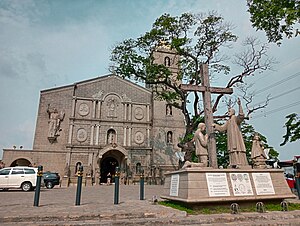
Cainta Church
Roman Catholic church in Rizal, Philippines
Distance: Approx. 1847 meters
Latitude and longitude: 14.578,121.1155
The Diocesan Shrine and Parish of Our Lady of Light, commonly known as Cainta Church, is a Roman Catholic parish church located along Andres Bonifacio Avenue in Barangay San Andres, Cainta, Rizal, in the Philippines. The church also operates a neighboring school, Cainta Catholic College. From its time of erection as a parish in 1760 until 1983, it belonged to the Archdiocese of Manila.
Taytay Church
Roman Catholic church in Rizal, Philippines
Distance: Approx. 529 meters
Latitude and longitude: 14.57125,121.13258
The Minor Basilica and Parish of Saint John the Baptist, commonly known as Taytay Church, is a Roman Catholic church located in Taytay, Rizal, Philippines. It is under the jurisdiction of the Diocese of Antipolo.
Manuel I. Santos Memorial National High School
Public high school in Rizal, Philippines
Distance: Approx. 2383 meters
Latitude and longitude: 14.54684,121.12513
Manuel I. Santos Memorial National High School (MISMNHS) is a public secondary school in Sitio Lambak, San Juan, Taytay, Rizal, Philippines. It was formerly an annex building of Taytay National High School and now an independent public secondary school. The school is named after Manuel Ignacio Santos who was then served as Municipal Mayor of Taytay (1946-1947), (1952-1960) and (1980-1981).

Taytay National High School
Public high school in Rizal, Philippines
Distance: Approx. 2417 meters
Latitude and longitude: 14.55554,121.14754
Taytay National High School is a public high school in Taytay, Rizal, Philippines. The school situated at Zloty St., Meralco Village of Barangay San Juan, was established in 1994.
Sierra Valley Gardens
Mixed-use development in Cainta, Rizal, Philippines
Distance: Approx. 1783 meters
Latitude and longitude: 14.583585,121.132438
Sierra Valley Gardens is a mixed-use development in Barangay San Juan, Cainta, Rizal, Philippines. It is a redevelopment of the former Mitsubishi Motors Philippines Inc. plant located on the boundary of Cainta and Taytay which is adjacent to the villages of Jansenville Subdivision, Saint Anthony, and Valley Golf.
Weather in this IP's area
overcast clouds
30 Celsius
37 Celsius
29 Celsius
30 Celsius
1008 hPa
79 %
1008 hPa
1007 hPa
10000 meters
3.68 m/s
5.24 m/s
266 degree
93 %
05:44:01
18:02:43