103.164.188.93 - IP Lookup: Free IP Address Lookup, Postal Code Lookup, IP Location Lookup, IP ASN, Public IP
Country:
Region:
City:
Location:
Time Zone:
Postal Code:
ISP:
ASN:
language:
User-Agent:
Proxy IP:
Blacklist:
IP information under different IP Channel
ip-api
Country
Region
City
ASN
Time Zone
ISP
Blacklist
Proxy
Latitude
Longitude
Postal
Route
db-ip
Country
Region
City
ASN
Time Zone
ISP
Blacklist
Proxy
Latitude
Longitude
Postal
Route
IPinfo
Country
Region
City
ASN
Time Zone
ISP
Blacklist
Proxy
Latitude
Longitude
Postal
Route
IP2Location
103.164.188.93Country
Region
uttar pradesh
City
kanpur
Time Zone
Asia/Kolkata
ISP
Language
User-Agent
Latitude
Longitude
Postal
ipdata
Country
Region
City
ASN
Time Zone
ISP
Blacklist
Proxy
Latitude
Longitude
Postal
Route
Popular places and events near this IP address
Jajmau
Sub-metropolis in Uttar Pradesh, India
Distance: Approx. 746 meters
Latitude and longitude: 26.46,80.35
Jajmau also known as Jajesmow during British Era, is a suburb of Kanpur, India. It is situated on the banks of the Ganges River. Jajmau is an industrial suburb.
British India Corporation
Central Public Sector Undertaking
Distance: Approx. 1495 meters
Latitude and longitude: 26.476393,80.339617
British India Corporation Limited (BIC) is a central public sector undertaking under the ownership of the Ministry of Textiles, Government of India. The CPSU produces textiles for use by civilians and the Indian armed forces. It manufactures the popular "Lal-imli" and "Dhariwal" brands of woollen products.

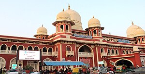
Kanpur Central railway station
Rail station in Uttar Pradesh, India
Distance: Approx. 1430 meters
Latitude and longitude: 26.4539,80.3512
Kanpur Central (formerly known as Cawnpore North Barracks, station code: CNB) is a central and junction railway station in the city of Kanpur and is one of the five central Indian railway stations. It is third busiest in country after Howrah Jn and New Delhi railway station. It is a major railway station between Howrah Jn and New Delhi.
Kanpur Sangrahalaya
Museum in Kanpur, India
Distance: Approx. 1216 meters
Latitude and longitude: 26.4668,80.3622
Kanpur Sangrahalaya (Hindi: कानपुर पुरातत्व संग्रहालय), also known as Kanpur Museum, is the official museum in Kanpur, the industrial hub of Uttar Pradesh, India. It was built by the British as King Edward Memorial Hall in honour of Edward VII. It is a storehouse of artifacts and exhibits that tell the story of the events and people who have influenced the making of Kanpur city, and tell many interesting details about the historical past of the city.
Nana Rao Park
Public city park in Kanpur, Uttar Pradesh, India
Distance: Approx. 1192 meters
Latitude and longitude: 26.471044,80.360935
Nana Rao Park / Company Bagh (Hindi: नाना राव पार्क / कम्पनी बाग़, कानपुर ) is a public city park in Kanpur, the industrial hub of Uttar Pradesh, India, built after Indian independence in honor of Nana Sahib. Prior to Indian Independence the location was known as Memorial Well and commemorated the massacre of British women and children during the Indian Rebellion of 1857.
Phool Bagh
Urban city park in North India
Distance: Approx. 1023 meters
Latitude and longitude: 26.467308,80.360248
Ganesh Shankar Vidyarthi Udyan / Phool Bagh (Hindi: गणेश शंकर विद्यार्थी उद्यान / फूल बाग़, कानपुर ), earlier Queen's Park, is an urban city park in Kanpur, the industrial hub of Uttar Pradesh in North India. It has been the location for many public meetings and political rallies in Kanpur from the early twentieth century.
Christ Church College, Kanpur
Distance: Approx. 691 meters
Latitude and longitude: 26.472542,80.352352
Christ Church College, Kanpur is a college established in 1866, affiliated with Kanpur University, in Kanpur, Uttar Pradesh, India. Earlier in 1840, SPG Mission School was established to educated Christian students. Later its name turned to present one.
Som Dutt Plaza
Distance: Approx. 843 meters
Latitude and longitude: 26.47404,80.347899
Som Dutt Plaza is a Non-AC Mall (marketing complex) situated adjacent to Naveen Market along the famous Mall Road in the city of Kanpur nagar, Uttar Pradesh. It shares the same complex with Hotel Landmark.
Generalganj Assembly constituency
Former constituency of the Uttar Pradesh legislative assembly in India
Distance: Approx. 367 meters
Latitude and longitude: 26.47,80.35
Generalganj (Assembly constituency) was a legislative assembly of Uttar Pradesh. As a consequence of the orders of the Delimitation Commission, Generalganj (Assembly constituency) ceased to exist in 2012.
Juhari Devi Girls' P.G. College
Distance: Approx. 1418 meters
Latitude and longitude: 26.46552,80.36417
Juhari Devi Girls' P.G. College is a college for girls in Kanpur, Uttar Pradesh, India. It is government aided and affiliated to CSJM University Kanpur.

Z Square Mall, Kanpur
Shopping mall in MG Marg, Kanpur
Distance: Approx. 780 meters
Latitude and longitude: 26.473239,80.352802
Z Square Mall is a shopping mall cum entertainment complex in the Indian city of Kanpur. The mall is spread on an area of five acres in the middle of Kanpur city with 900,000 sqft. of built-up area and the presence of more than 150 National & International brands.
Halim Muslim PG College
Distance: Approx. 1499 meters
Latitude and longitude: 26.4643,80.3352
Halim Muslim PG College is an educational institution in Kanpur of Uttar Pradesh state in India. The college was established in 1959 by the Muslim Association in Kanpur. by Hafiz Mohammad Haleem (1856–1939), who was inspired by the noble ideas of Syed Ahmad Khan, the founder of Aligarh Muslim University.
Weather in this IP's area
clear sky
17 Celsius
16 Celsius
17 Celsius
17 Celsius
1014 hPa
50 %
1014 hPa
1000 hPa
10000 meters
2.56 m/s
2.57 m/s
287 degree

