103.163.0.109 - IP Lookup: Free IP Address Lookup, Postal Code Lookup, IP Location Lookup, IP ASN, Public IP
Country:
Region:
City:
Location:
Time Zone:
Postal Code:
ISP:
ASN:
language:
User-Agent:
Proxy IP:
Blacklist:
IP information under different IP Channel
ip-api
Country
Region
City
ASN
Time Zone
ISP
Blacklist
Proxy
Latitude
Longitude
Postal
Route
db-ip
Country
Region
City
ASN
Time Zone
ISP
Blacklist
Proxy
Latitude
Longitude
Postal
Route
IPinfo
Country
Region
City
ASN
Time Zone
ISP
Blacklist
Proxy
Latitude
Longitude
Postal
Route
IP2Location
103.163.0.109Country
Region
yamaguchi
City
yanai
Time Zone
Asia/Tokyo
ISP
Language
User-Agent
Latitude
Longitude
Postal
ipdata
Country
Region
City
ASN
Time Zone
ISP
Blacklist
Proxy
Latitude
Longitude
Postal
Route
Popular places and events near this IP address
Yanai, Yamaguchi
City in Chūgoku, Japan
Distance: Approx. 377 meters
Latitude and longitude: 33.96388889,132.11861111
Yanai (柳井市, Yanai-shi) is a city located in Yamaguchi Prefecture, Japan. As of 31 May 2023, the city had an estimated population of 29,821 in 15298 households and a population density of 210 persons per km². The total area of the city is 140.05 square kilometres (54.07 sq mi).
Hirao
Town in Japan
Distance: Approx. 5161 meters
Latitude and longitude: 33.93805556,132.07333333
Hirao (平生町, Hirao-chō) is a town located in Kumage District, Yamaguchi Prefecture, Japan. As of 31 May 2023, the town had an estimated population of 11,064 in 5394 households and a population density of 320 persons per km2. The total area of the town is 34.59 square kilometres (13.36 sq mi).

Kumage District, Yamaguchi
Distance: Approx. 5828 meters
Latitude and longitude: 33.934,132.068
Kumage (熊毛郡, Kumage-gun) is a district located in Yamaguchi Prefecture, Japan. As of 2003, the district has an estimated population of 42,778 and a density of 282.12 persons per km2. The total area is 151.63 km2.

Tabuse Station
Railway station in Yanai, Yamaguchi Prefecture, Japan
Distance: Approx. 6787 meters
Latitude and longitude: 33.95868306,132.04417306
Tabuse Station (田布施駅, Tabuse-eki) is a passenger railway station located in the town of Tabuse, Kumage District, Yamaguchi, Japan. It is operated by the West Japan Railway Company (JR West).

Ōbatake Station
Railway station in Yanai, Yamaguchi Prefecture, Japan
Distance: Approx. 6074 meters
Latitude and longitude: 33.96272222,132.18258333
Ōbatake Station (大畠駅, Ōbatake-eki) is a passenger railway station located in the city of Yanai, Yamaguchi Prefecture, Japan. It is operated by the West Japan Railway Company (JR West).

Yanaiminato Station
Railway station in Yanai, Yamaguchi Prefecture, Japan
Distance: Approx. 1842 meters
Latitude and longitude: 33.9582,132.1339
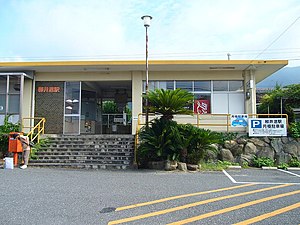
Yanaiminato Station (柳井港駅, Yanaiminato-eki) is a passenger railway station located in the city of Yanai, Yamaguchi Prefecture, Japan. It is operated by the West Japan Railway Company (JR West).
Yanai Station
Railway station in Yanai, Yamaguchi Prefecture, Japan
Distance: Approx. 1007 meters
Latitude and longitude: 33.9659,132.10616944
Yanai Station (柳井駅, Yanai-eki) is a passenger railway station located in the city of Yanai, Yamaguchi Prefecture, Japan. It is operated by the West Japan Railway Company (JR West).
Hatano-ike Dam
Dam in Yamaguchi Prefecture, Japan
Distance: Approx. 5033 meters
Latitude and longitude: 34.00083333,132.08083333
Hatano-ike Dam is an earthfill dam located in Yamaguchi prefecture in Japan. The dam is used for irrigation. The catchment area of the dam is 1.1 km2.
Ishii Dam
Dam in Yamaguchi Prefecture, Japan
Distance: Approx. 3141 meters
Latitude and longitude: 33.995,132.11277778
Ishii Dam is an earthfill dam located in Yamaguchi prefecture in Japan. The dam is used for irrigation and water supply. The catchment area of the dam is 2.3 km2.
Kurokui Dam
Dam in Yamaguchi Prefecture, Japan
Distance: Approx. 5405 meters
Latitude and longitude: 34.00444444,132.07972222
Kurokui Dam is an earthfill dam located in Yamaguchi prefecture in Japan. The dam is used for water supply. The catchment area of the dam is 3.2 km2.

Kurokuigawajoryu Dam
Dam in Yamaguchi Prefecture, Japan
Distance: Approx. 4297 meters
Latitude and longitude: 33.99666667,132.08722222
Kurokuigawajoryu Dam is a gravity dam located in Yamaguchi prefecture in Japan. The dam is used for flood control. The catchment area of the dam is 7.7 km2.

Yanai Chausuyama Kofun
Distance: Approx. 1105 meters
Latitude and longitude: 33.96583333,132.12888889
Yanai Chausuyama Kofun (柳井茶臼山古墳) is a Kofun period keyhole-shaped burial mound, located in the Yanai neighborhood of the city of Yanai, Yamaguchi in the San'yo region of Japan. The tumulus was designated a National Historic Site of Japan in 1948.
Weather in this IP's area
few clouds
11 Celsius
10 Celsius
11 Celsius
11 Celsius
1013 hPa
49 %
1013 hPa
1001 hPa
10000 meters
5.24 m/s
6.67 m/s
259 degree
14 %


